AGM Documents – Sat 23 November

RAMBLERS’ EAST CHESHIRE GROUP

2019 ANNUAL GENERAL MEETING

Saturday 23rd November 2019 at 2.00 p.m.

To be held at Macclesfield Tennis Club, Learning Zone Campus,

Park Lane, Macclesfield, SK11 8LF

Agenda

  1. Apologies for absence
  2. Minutes of the AGM held on 24th November 2018 for approval
  3. Matters arising from the minutes
  4. Annual Reports from officers

Chair: Jane Gay

Treasurer: Colin Finlayson

Membership secretary: Sue Munslow

Social & Events Secretary: Maggie Swindells
Footpaths Committee Chair: David Barraclough

Publicity Officer: Colin Park

  1. Election of Officers and Committee

Chair (Jane Gay)

Secretary (Vacancy)

Treasurer (Colin Finlayson)

Membership Secretary (Sue Munslow)

Social & Events Secretary (Maggie Swindells)

Footpaths Committee Secretary (Dave Barraclough)

Publicity Officer (Colin Park)

Committee Member (Keith Anderson)

Note. Kathryn Carty has put forward her name for election as Secretary (duly proposed and seconded). No other nominations were received by the cut off date.

  1. Motions Received – None
  2. Appointment of Independent Examiner (Auditor of Accounts)
  3. Any other business

Adrian Flinn – Secretary

9th November 2019

Coffee, tea and cakes will be served after the AGM

Ramblers East Cheshire Group Minutes of the Annual General Meeting held on Saturday 24 tht November 2018 at Macclesfield Tennis Club ( subject to approval at the

AGM 2019 )

There were 45 members that signed the attendance register (with guests 50 people were in attendance).

Welcome

The chair welcomed members to the AGM and thanked them for attending.

Apologies for absence

The following members sent their apologies: Dave & Jane Collorick, Brian Griffiths, Keith Anderson, John & Pauline Handley, Benita Kassas, Claire Sependa, John & Jenny Irwin and Graham Walker.

Minutes of the AGM held on 11 th November 2017

The minutes were accepted unanimously as a true and fair record of this meeting (proposed by Helen Richardson and seconded by Ruth Harrison)

Matters arising from the AGM held on 11 th November 2017

None

Annual Reports from Officers ( posted in the website for reference)

    1. Chair

During her address to the meeting the Chair highlighted:

  1. The systems that ECR are using to safeguard data are in compliance with the new Data Protection regulations that came into force early this year. Also, each member had to update their personal details in the Ramblers Association database to comply with these regulations and to continue to receive notices of events by email from ECR – this caused a situation where some members had not been receiving emails but most have been resolved. To help we are now putting the notices about trips and activities in our website under the heading “Information for members”
  2. A “Plea for help “ questionnaire was sent to the membership. Although not many people replied we had offers from volunteers to join the Committee, lead walks including stroller walks, organize different types of social events and to become footpath inspectors
  3. Congratulated the Footpath Committee, our FP Inspectors and the Database manager for the unprecedented achievement of 100% completion in the Inspection of our paths.
  4. The use of the permissive path at Charles Head has been extended for a further 5 years.
  5. The number of walks that ECR put on each week is amazing. The Committee are looking at putting on some sort of training and developing a “buddy” system to encourage new walk leaders to volunteer. The Ramblers Association are planning to set up a walk leaders training events (free of charge) to be rolled out across the country.
  6. The National and ECR websites get very positive feedback especially from new walkers when looking for walks in our area. Also, Committee members are placing leaflets in GP’s surgeries, libraries , etc. in our area so that new walkers can access our programme and decide which one they would like to join – for this

reason we encourage that walk details are posted in the ECR website 2 weeks prior to the walk to allow posting in the national website. However this is not compulsory and is up to each individual leader to enter the walk details onto the ECR website as and when they see fit.

  1. Committee members have been handing out new Medical Emergency Cards on walks to encourage walkers to carry medical information with them.
  2. The Cheshire East Area AGM was held on 16th November 2018 and two representatives from Ramblers Association were in attendance. The meeting was hosted by South Cheshire (minutes are awaited). The concerns on Lost Ways expressed by our Footpath Committee were discussed and supported by all three groups and a meeting will be set up with the Central Office coordinator on this matter early in the New Year.
  3. Thanked all the Committee Officers and all volunteers for their dedicated hard work, time and effort in organising all our varied activities.

A question from the floor relating to the coverage of third party liability insurance provided by the Ramblers Association asked whether any person in a walk is covered in case of an accident. The view is that the leader and back marker only are covered by this insurance provided that both are current members of the Ramblers Association.

Treasurer

Key points made during the address were: a) Overall we had a very small deficit of £381.67 although the bank balance at year end stands at £4801 (down from £5182 in the previous year). b) Only a minor amount of routine footpath maintenance have been carried out this past year amounting to £700. c) ECR budget application

for next year totaled £1200 and has been approved by Central Office. d) Members were encouraged to use the internet bank payment facilities for our self funded events to minimize the cost to ECR of the bank charge of 30p per cheque paid into our Unity Trust Bank when using a clearing bank (including the Post Office).

There were no questions from the floor.

Membership Secretary

Over this year membership has remained stable throughout with 593 members showing high retention and a steady supply of new members. The national membership continues to decline at a rate of about 2% each year.

There have been concerns reported by Walk Leaders that in a few instances there might have been a person joining a walk and not being a member of the Ramblers Association (this is being followed up with Central Office). This example raised the question as to how many persons are walking in our group who are not members. The Committee will look into this matter further and consider using the newly available Walk Register App from the Ramblers Association (with this app Walk Leaders can register members and non members on walks either by scanning the code in the cards or inputting details manually). The Publicity Officer and the Webmaster were thanked in particular plus all others for helping to publicise and encourage our activities. Walk Leaders and members on walks were encouraged to welcome new members and make them feel confortable on walks.

The following members that had passed away in the past year were remembered with a minute silence: Michael Bull, Margaret Atherton, Len Wakefield, and J. Cook

There were no questions from the floor

Social & Events Secretary

There has been a great variety of events over the last 12 months and a massive “thank you” goes to everyone involved in the organization and running of events for ECR and the two volunteers involved for the last 3 years in the Walking for Health initiative.

The Committee decided to put on a trial stroller walks programme which run on alternative Fridays and dovetailed into the Walking for Health programme. This has been very successful and, therefore, this programme will run next year – a volunteer has come forward to act as coordinator. There were 3 coach trips organized in 2018 (cf. 2015 and 2016 when there was one trip in each year). We already have two dates on next year programme for coach trips. Also, we have 2 weekends away planned which are open to all and 2 weekends for long walkers. Two evening meals were organized in 2018. The social calendar for the first half of 2019 will be out soon with all the dates.

There is a vacancy for Social Secretary or Social Coordinator – it is not necessary to sit on the Committee to fulfill this role.

Anybody interested please contact the Chair. There were no questions from the floor.

Footpath Committee Chairman

The following were highlighted: a) the Committee is completing its 33rd year of operation b) for the second consecutive year managed to inspect all 1,276 paths in our group area of 33 parishes c) consulted on 11 proposed diversions in the year to end September 2018 d) a new member has been coopted into the Footpath Committee e) one of the two Officers in Cheshire East Rights of Way team has handed his notice – the Footpath Committee will lobby the Council to appoint a replacement asap.

There were no questions from the floor.

Publicity Officer and Lost Ways project Manager

This year articles have been published in the Macclesfield Express every single week – walk leaders are asked to keep up the supply of articles for next year. A suggestion was made to post these articles in the website – will be explored further by the Committee.

There are 19 “lost ways” in our area that are worth pursuing for various reasons. The next step is to research documents held at the local Council Offices to provide legal support of the existence of the right of way in the19 paths then the process of making an application can start. Three volunteers have offered their services to work on this project together with the Project Leader. The concerns from the Footpath Committee were raised at the recent Cheshire East Area AGM – see 4.1 (h) above.

There were no questions from the floor.

Other Reports

    1. Footpath Maintenance Projects Team

The Coordinator provided a review of the work conducted since the last AGM. Because of the Coordinator personal commitments some work was conducted in December 2017 but no projects were undertaken this year. However, the Coordinator proposes to re- commence project activities in 2019.

There were no questions from the floor.

ECR Walk Statistics (posted in the website for reference)

The group continuous to run over 300 walks per year. The statistics show that the group depends too much on Walk leaders that volunteer to lead multiple walks in the year in order to maintain this large number of walks provided to the membership. It was

noted that the Weekend Medium Walk Coordinator needs more volunteers to lead walks.

Ralph Atherton was thank for the 20 years that he has been compiling these figures and producing annual reports for AGM’s. This task will be taken over by Andy Davies.

There were no questions from the floor.

. Election of Officers and Committee

The following stood for reelection and were elected unopposed (proposed by Ann Thompson and Ian Mabon):

Jane Gay (Chair), Adrian Flinn (Secretary), Colin Finlayson (Treasurer)), Sue Munslow (Membership Secretary), Kathryn Carty (Committee Member), Dave Barraclough (Footpath Committee representative), Colin Park (Publicity Officer and Lost Ways Project Manager), Maggie Swindells (Committee Member) and Keith Anderson (Committee Member).

We need a volunteer to take up the vacant Social & Events Secretary position.

. Appointment of Independent Examiner ( Auditor of Accounts)

Ken Hobbs was reappointed unanimously (proposed by Mike Harding and Mike Murphy)

  1. . Motions None.

Commendation Awards

Two awards from the Ramblers Association were presented in recognition of outstanding contributions over a long period of time serving as volunteer in ECR to:

  • Alan Catherall joined 33 years ago leading walks, as a member of the Committee and a valuable member of the Footpath Committee (retired from this Committee after 25 years). Also, Alan was involved in negotiating and securing many rights of way in our area.
  • Peter Cummins has been an active member of ECR since 1981 (37 years ago) and was a founding member of the Footpath Committee in 1986 until retirement in 2016.
  1. Any other Business None.

The meeting closed at 4 pm

Adrian Flinn – ECR Committee Secretary 13th December 2018

Dates of Meetings to be held in 2019 (venues to be confirmed in late summer):

  • ECR 2019 AGM – date to be confirmed later
  • The Area AGM date to be confirmed later

2019 AGM – CHAIR REPORT


This is my second report and how quickly the last two years have gone. I am writing this while in Australia so apologies for anything which I miss out. I had intended to complete it before leaving home in mid September but time caught up on me and hence I’m writing it late October. 

Since we are a walking group, I will start with our walks programme. Many thanks to everybody who contributes to this as it is an amazing programme with varied walks in length and grade. This year has seen the strollers programme, which is on a Friday, become embedded in the system. It seems to be very popular and a massive thank you to Tony W for coordinating it all. The other programmes have run with radical variations in the numbers of walkers. There has been much discussion about this at committee level and also amongst members. We feel that this is due to a number of factors, one being the weather, another the distance from home and the third being the fact that the age profile of the group is not getting any younger. We have decided to leave things as they are for the moment as there was such a great diversity of opinion that no clear way forward evolved.

The committee has also discussed the cost of membership compared to other walking groups and have contacted Central Office about our concerns. 

I must thank the footpath committee for all the work that they do. As you will realise from other reports we have made a donation to save the Harrop Brook Bridge. This is a “lovely little bridge which we didn’t want spoilt by a wooden structure“ A lot of the work of the footpath committee goes completely unnoticed by the vast majority of the Ramblers. It is essential work in keeping all the footpaths open and accessible for us to walk. This committee has a wealth of knowledge and for that and all they do I thank them as I’m sure do all the members. 

I thank Neil Collie who attended national conference, initially as an observer, but when we realised the Area was not going to be represented he attended as a delegate. He has put a report onto the website. He came to a committee meeting and reported back to us. He said that it was a highly organised and slick event. The first priority was to discuss the slow decline in membership over the last 15 years, they recognise that only 40% of members go on organised walks so I’d be interested in any ideas on how to retain the non walkers. Neil suggested that we have an Area Chair which we actually do have. The Chairs of the 3 groups carrying out this role on a yearly rotation. Obviously this needs to be made clear to the membership, so now you know, as they say!! 

While talking about the Area AGM this has now been moved until after group AGM’s as suggested by Head Office.

Cheshire East Area volunteered to trial the national First Aid training and we were selected eventually the date of the 20th of March was agreed and ECR filled 11 of the 22 places available. I think everybody who went learnt something and came away feeling more confident about dealing with a serious emergency; this I think could become part of our annual programme. 

The walks programme is now a standing agenda item on every committee meeting so if you have any observations to make please forward to the secretary or myself. 

I have met with Roger on a couple of occasions to discuss the website. As a result of these meetings Frank took over circulating emails while I posted information on the website. This was just a short term solution and now Steve H is circulating emails and Maggie posting information on the website. Frank and I are the backups! 

We are looking for people with Facebook, WhatsApp and instagram knowledge so that we can make this part and parcel of our means of communication. If you feel you can help in any way then please just contact me. We have to try and attract younger members and I am assured that this is one of the best ways of doing so.

We ran a walk leader introductory course on July 4. Gillian Kay was the lead on this and prepared the whole course and had meetings with the trainers some of whom were a little bit nervous about what exactly we were being asked to do. I have to say the course was amazing and brilliantly run and organised. Every single candidate said that they had enjoyed the course and also that they had got a tremendous amount from it and now felt more confident about leading walks. The morning session was theory with the afternoon session being a practical session around Gawsworth which was at exactly the right level for the candidates. A massive thank you to Gillian and also the other instructors, Susan M who led the session on 6 figure references and showed us a fail-safe way of always getting it right! David G, Michael M, Frank and myself were the other trainers and we also enjoyed it. Depending on demand we may well put this on annually. 

I have absolutely no intention of listing a large number of people that I would like to thank for their support and help because I am bound to miss somebody out. Is the person who leads one walk every six months less important than anybody else since we are a walking group and without them we would not survive?  It would be great if everybody felt confident enough to try and lead at least one walk in each six month programme .If there is anything you need to help you in doing this then please just email me. I feel this is one of the most important tasks for all of the membership to encourage new people to lead. I totally acknowledge that some people don’t wish to lead, for what ever reason, and please don’t feel under any pressure to do so.

The one group of people I do feel I need to thank is the committee. They have kept me on the straight and narrow and been extremely supportive in all that I have tried to do. 
I’m delighted to say that the vast majority are willing to stand again next year. 

Adrian, the secretary is leaving after he has served on the committee for three years. Two of these years with me and one with John Edwards. I thank him for the commitment that he has made to this role and for his very precise minuting of the meetings. This has made following up on issues very easy. Kathryn Carty is prepared to take on this role. 

A massive thank you to Colin P who  is resigning from his role of Lost Ways Coordinator. Colin I know has spent many hours on this, using his expertise to improve the quality of data in this Cheshire wide exercise and identifying about 500 possible Lost Ways. We need somebody else to take this role on and I am sure that Colin would be very happy to explain all the work that he has done so far. He is remaining as Publicity Officer.

Maggie took over the Social Secretary job earlier this year which was amazing as far as I was concerned. It shows really that a change of role produces new ideas as she has brought in several talks which have been well supported. Thanks Maggie, I now only have to write one report!

The committee desperately needs a couple of new members. We meet four times a year, in the afternoon but this is not set in stone, so it is not an onerous task and one that I hope several of you will consider. Coffee, tea and cakes are served at the meetings!

This report seems rather short but since the minutes of all our meetings are posted on the website those of you who want to know the details of our discussions will have read the minutes and so this is a brief summary of the year. 

Looking forward to seeing you all at the AGM.

Jane Gay 


2019 AGM – ECR Membership Report November 2019

Since the last AGM our numbers have gone down from 593 to 566. This is inline with national figures and other groups. Later retirement and growth of other walking groups partly explain these numbers

Each month only three to four walkers join us and this year some figures have shown a 1/3 of new members not re-joining after a year. Again, there may be many reasons for this, but welcoming new members on their first walks is very important.

One way in which we can help recruit new members is by leaving our advertising leaflets in local leisure centres, medical centre and libraries. Recent new members have said they have chosen ECR rather than another group because we have numerous walks to choose from including regular long walks. We also have a huge range of social activities during the year that are very popular and often booked up.

Central Office are concerned over numbers and keeping new members. They have suggested:

– send them a personalised email

– send them a welcome ‘shout-out’ on your group’s Facebook page

– let them know they can bring a friend or family member to their first group walk.

– highlight any ‘introductory walks’ we do for new walkers – ideally shorter walks at an easier pace.

– let them know about any social events you’ve got coming up.

– make sure your walks include an easy-to find starting point. With a postcode and clear description.

– the leader should ask at the beginning of a walk are there any new walkers and others should make a point of talking with them as you walk.

– say you hope to see them again soon.

– give a clear run-through of what to expect on the walk, including the next refreshment point and loo break.

– make sure there is a back marker to help keep an eye on everyone

– finish the walk at a pub or café to give new people a chance to socialise with the group.

– at the end of the walk, ask them how they found it and if they have any feedback on how it could be better.

You will probably agree that as a group we are giving our new members a good welcome.

Sue Munslow

2019 AGM – Publicity Report

This year has seen walk articles appearing in the Macclesfield Express on all but one week despite an article being submitted.

I am always on the lookout for new articles from anyone willing to write a short piece on a recent walk they have led. Please don’t hesitate to contact me with anything which might be worth publishing not only in the local newspaper but also on the ‘Recent Posts’ section of our website.

For anyone who doesn’t get sight of the Macclesfield Express, walk articles now appear on the ‘Recent Posts’ section of our website and usually have more than one photograph.

I would welcome walk articles from anyone leading walks in the future especially if it’s a new or unfamiliar area to the group. Articles should be between 250-350 words in length and can include a bit of history about the area you are walking through and not a series of directions. I can edit the information if required so that it can be published in the Macclesfield Express. Your article should be accompanied with a photograph(s) in a JPEG format if possible.

If you would like to write an article but are not sure how to go about it then I am more than willing to talk it through with you or you can refer to past articles published on our website to see the stile.

Colin Park

FOOTPATH COMMITTEE REPORT TO THE ECR 2019 AGM – Nov 23rd 2019

2019 has been an active but fairly routine year of the Footpath Committee activities. Below is a summary of the key points of our work.

The Footpath Committee now has a complement of six, with the addition of Nick Brearley who is assuming a role to identify potential maintenance work from the results of the footpath inspections. The Committee members are Tony Battilana, Nick Brearley, Neil Collie, Colin Finlayson, Graham Walker and Dave Barraclough. We generally hold 4 meetings each year and operate with a high degree of independence from the Main ECR Committee. All members are continuing in these roles for 2020 but we would always welcome new volunteers to assist with our work. One particularly role would be someone to review and analyse the footpath inspection results for trends and produce the reports that we send to Cheshire East PROW Officers. This task need not involve attending our meetings.

A notable piece of maintenance work organised by Nick Brearley in collaboration with the Projects Group was to organise to remove vegetation that has made the Over Alderley FP2, within the National Trust Alderley Edge land. We plan to continue cooperation with the Projects Group.

We are now getting accustomed to reporting a 100% inspection of the footpaths in our area, now the third occasion. This is currently 1282 paths over 36 parish area carried out by 38 volunteer inspectors. Thanks are due to Tony Battilana for his thorough organising of this task. The results now extend over 10 years and there has been a steady and notable reduction in the number of paths with significant problems (our C and D paths). The average level in the first 5 years from 2009 was 11.6%, then reducing to 8.9% in the next 5 years – and in 2019 it has reduced to just 6.2% – a commendably low level. As usual, we should recognise the efforts of Cheshire East PROW Department and its Footpath Enforcement Officers in achieving this result. We are more fortunate than many other areas.

We have also been routinely consulted by Cheshire East over 9 Diversion applications and commenting on major road developments. We generally involve our footpath inspectors in formulating our responses.

There are two noteworthy examples. Firstly the new A6 to Manchester Airport Relief road was opened in October 2018 and includes extensive footpaths and cycleways throughout it’s length. It provides some valuable additions to the footpath network and is welcomed. However, Stockport Council’s management of the contract was inadequate and the contractor failed to provide gates in the boundary fence where existing footpaths joined or crossed the new road. It has taken 12 months of pressure by members of the Committee to get these faults corrected. There are still two footpaths which remain obstructed and unusable.  We are also pressing for pedestrian gates to be provided in a number of locations where only heavy field gates have been fitted in contravention of Cheshire East Council’s policy of ‘least restrictive access’ on new diversions.

Secondly, special attention has been a path between Rainow and Kettleshulme that has been obstructed for all the years East Cheshire Ramblers has existed. It is now the subject of an appeal to the Planning Inspectorate by the landowner who wants to delete the path from the Definitive Map.  With the help of Central Office we have prepared a rebuttal to his appeal and await the Planning Inspector’s report.

Two further events are worthy of special note. Firstly, ECR agreed to donate £500 towards the reinstatement of a partially collapsed old packhorse bridge over Harrop Brook at Pott Shrigley. The actual work is still to be completed during 2020.

Secondly, we should acknowledge the significant work of Colin Park in developing the listing of potential Lost Ways across Cheshire. Colin is standing down from leading the ECR work (to concentrate on both extensive walking and leading publicity for the ECR website and local newspapers). We should recognise that his considerable professional expertise in cartography assisted the Cheshire exercise over several years to draw up the list of about 500 potential Lost Ways. The Cheshire Footpath Secretaries are currently lobbying the national ‘Don’t Lose Your Way’ campaign to pay greater attention to the need to prioritise and quantify the cost of the numbers of claims that are made. We believe that excessive numbers of claims could detract from the existing PROW resources.

We hope that the efforts of the Footpath Committee contribute to your enjoyable and safe walking across East Cheshire. Any offers of help would be appreciated in such tasks as future Footpath Inspectors or assisting the Committee in analysing the inspection results trends. Please e mail me on dave@thebarracloughs.co.uk

Dave Barraclough

Chairman – ECR Footpath Committee – November 2019

AGM 2019 – Social & Events Report

It was with some trepidation that I took on the role of East Cheshire Rambler’s Social Secretary in November 2018. I was stepping into the shoes of a social secretary legend! Needless to say I’ve had a huge amount of support and encouragement from Jane plus lots and lots of help from my fellow ramblers who have continued, over the course of the year, to give up their time to provide a rich and varied social programme for our group.

Three excellent Christmas lunches, preceded by walks were organised by Teresa, Andy, Peter, Jane, Frank, Georgie and David. Last year we also enjoyed two other walks with a Christmas theme. In December a walk from Chelford was organised to allow us to enjoy the Barnaby Choir singing carols at St Mary’s Church at Nether Alderley. Unfortunately, the timings were slightly off and we got there at the end of the first performance! This year we’re repeating the event and we’re hoping for better walk timings and hopefully a mince pie!

Rosie Forth, who has led many walks for the short walkers, has quietly, and traditionally, led a mid-week short walk in December. Her walks traditionally include a Roses Chocolate or two at coffee time and lunch at the Admiral Rodney with Christmas Crackers. I’d like to thank her for leading so many walks for the Ramblers over the years. We will miss her ‘Christmas’ walk this year.

‘Keith’s Sherry Walk’ continues to provide an excellent start to the New Year and our thanks go to Lorraine and Melanie for continuing the tradition and leading and organising the first walk of the year.

In February Duncan Leamond provided an excellent talk for members about the Macclesfield canal. Duncan’s talk was informative and entertaining and I’m sure many walkers will walk our local canal with a different perspective on the time and effort which goes in to maintaining the “watery pathways” we enjoy each year as part of our walking programme.

Over the course of the year walkers have been able to access several weekends away organised by our members. The amount of time and effort which goes into preparing these opportunities is enormous and I’d like to thank, on behalf of us all, Georgie and Peter Everson, Steve Hull, Melanie Davy and Ann Thompson for all the time and effort they have put into organising successful weekends away for members. Colin Park and Steve Hull have already provided dates for the long walkers weekend in the next programme and I’d be delighted to hear from anyone interested in organising other weekend away opportunities in 2020.

Over the course of the year we’ve also had the opportunity to enjoy a number of special walking social events. Brian Griffiths, Colin Park and Tony Litter led short walks which culminated in a picnic and talk at Toad Hall, the home of the Blackden Trust and Alan Garner the author of The Weirdstone of Brisingamen and many other novels based in Cheshire. They were a great addition to the programme and greatly enjoyed by those who were able to attend! Brian also organised a tour of the Air Raid Shelters in Stockport.

In the summer Jane Gay offered a walk with Martin James, the ranger at Teggs Nose.

This year the ramblers participated in two coach tours which took us to Arnside, organised by Steve Hull, and to Conwy, organised by Gina Thompson, Annette Hurst and Maggie Swindells. Thanks to to Colin Park, Ruth Harrison and Rob Stevenson for leading walks for the coach tours.

In August we offered walkers the opportunity to join Rodney Hughes on a History Walk from Wincle followed by a meal at the Wincle Brewery. This proved to be so successful Rodney has agreed to do another one next summer.

Meals out in the summer continue to be popular and thanks go to Ann Thompson for organising a walk followed by a meal at Monyash and to Nick Wild for kindly offered to end the summer evening programme of walks with a meal at Rosie Lee at Hayfield.

To end the year, in October, we had excellent attendance for Judith Wilshaw’s talk about local history in our locality. She’s offered to lead a walk for us next year in Castleton or Stockport as a follow up to her talk.

I’m sure I’ve not mentioned everyone who contributes to the social programme and apologies if I’ve left anyone out. Our social programme depends so much on the generosity of members who are prepared to give up their time to provide events for all of us and I’d like to thank them all, on behalf of all the members, for their time, enthusiasm, imagination and continued support.

Maggie Swindells

Walking the Peatlands Way in three days


One area I have never explored on foot is the countryside covering the vast peat lands which occupy the area between Doncaster and Scunthorpe and include the Isle of Axholme. This would make a walk of three days covering the permissive paths that cross the Thorne and Hatfield Moors and a sparely populated area. During the summer of 2019 I set out along this trail on an adventure which didn’t quite go to plan. The latest Ordnance Survey maps show the route plotted and from my research I was expecting the trail to be well signposted but as it turned out, way marking was virtually nonexistent.

The trail can be found on the following website www.bing.com/maps

Following the Peatlands Way across the Isle of Axholme. Good paths under big skies.

Day 1 – When the number 87 bus saves the day

The Peatlands Way, is a relatively new recreational path around an area not normally associated with walking. I had planned this trek out carefully by using buses and trains and so on this first day it was merely a case of catching the train from Crowle Railway Station where I had parked the car, to Hatfield and Stainforth Railway Station and then walking back. The train was on time and I nearly had a free journey as the conductor only reached me as we pulled into Hatfield and Stainforth Station.

To reach the Peatlands Way it was a walk through this ex mining community which today has little appeal but there has been a settlement here since Anglo Saxon times.

On the northern edge of the community I looked for way markers for the Peatlands Way but there were none. I crossed the narrow and busy road bridge over the River Don and struck out north eastwards along a good riverside embankment with little to note in the flat countryside. I later left the embankment to enter the far more attractive village of Fishlake. People were out tending public gardens and a host of women were cleaning the church. This as I soon found out was the ‘Monday Club’ a group of retired residents who looked after the village. What a good idea I thought. I had a wander around the church and entered via the fine Norman south door. Much of this fine church dates from the 14th and 15th centuries. According to Wikipedia there is a local myth called “The Cockatrice of Church Street”. The story goes that the mythical beast resides near the Churchyard, and those unlucky enough to hear it’s call are said to never sleep again. Let’s say that after a good day walk I always get a good night sleep and I never heard anything untoward.

Entering the attractive village of Fishlake.
The fine Norman south door at St Cuthbert’s Church in Fishlake.

I returned to the embankment and shortly took a path to the left through trees then over a road before following a series of enclosed tracks which gradually became overgrown but improved again later. Reaching the next road I found the road bridge over the River Don closed due to refurbishment and my negotiations with the workmen to cross the bridge failed. This was a major blow and after studying the map, my only option was to return to Stainforth which was almost back to where I started out. I was fuming as I headed back but this time I followed the embankment the whole way despite it not being a right of way. Nearing Stainforth I walked closer to the River Don as this was the true right of way but a route few used. I had however at the start of my walk today noted the bus timetables when I set out from Stainforth earlier and knew that there were buses every twenty minutes towards Thorne. It was the only sensible thing to do was to catch a bus to Thorne and pick up the trail again there. From the bus stop timetable, a bus was due anyway and the number 87 whisked me through to Thorne. If I had walked the whole way to Thorne it would have been around twenty three miles of walking today.

Alighting in Thorne I calculated that I was only around an hour behind schedule but I felt a bit like Julia Bradbury or Tony Robinson who set out on a walk when they are presenting a television programme only to ‘cheat’ by hitching a ride part way through the walk.

I now headed through the town along Finkle Street, lined with small shops, and today quite a bustling place. Beyond, it was a case of following residential streets before following a path across wasteland full of bramble bushes and tethered gipsy horses on any grassy areas. A further downside was the amount of fly tipping in this area. It was lunch time as I reached another ex mining community of Moorends entering via Bloomhill Road and leaving via Grange Road. This community was quite an unattractive place with many shops boarded up and even vandal bars at places of worship. There were youths hanging around and I really just wanted to get out of the place as soon as possible. Leaving the community I did find a recreation ground with a vandal prove seat which was adjacent to the Thorne Colliery Football Club. It wasn’t the best of places to stop for lunch with youths riding mopeds around with no helmets.

I was keen to set off and soon rounded the abandoned area in which was once Thorne Colliery. Still I had no way markers to follow but at least I had marked up the route of the Peatlands Way on my Explorer Maps. A reasonable track led out onto Thorne Waste or Moors which formed part of the massive Humberhead Peatlands National Nature Reserve. This area forms the largest lowland peat bog in Britain and I was about to cross it. Now route finding wasn’t going to be too clever but I reached the point where there were several information boards. Crikey! This place is full of snakes I thought as I read the details and warnings on the information boards. Adders and grass snakes were in abundance in this part of the world and there were several signs to remind you. Out came the walking pole so that I could prod the ground in front of me if required.

I thankfully came across the first of several way markers for the Peatlands Way – a symbol of the nightjar and these moorlands is one of the best areas in Britain where they can be found not that I saw any.

Information boards on Thorne Waste. Beware of the snakes was not an under estimationas I was soon to find out.
I nearly stood on this fellow as it blended in with the ground. Backing off I got my camera out to get this photograph before it slithered into the undergrowth.

With eyes peeled to the ground I set off along a series of paths looking for any movement in the grass. The only trouble was that the grass hadn’t been cut for some time and so it was more than ankle deep. Way-markers were often hidden in wayside vegetation and so I stopped several times and estimated how many minutes it was to where I had to look for a turn. In places I was walking between tall reeds and half expected to meet Doctor David Livingstone coming the other way. After several twists and turns I eventually came to an straight track which I would follow east southeast for around one and quarter miles and I estimated that this would take me around twenty five minutes before looking for a path on my right. The countryside was very flat and full of lakes and bogs and the only sign of the modern day world was a distant chimney of a power station and the top of distant wind turbines. Time to get moving I thought so I upped my pace and less scanning the ground ahead of me as I was now on a clear track. After a quarter of a mile I stopped dead in my tracks as I was about to tread on a fully grown adder. I carefully backed off and got my camera from my rucksack before creeping up on the reptile to get some close up photographs before it slithered away into the undergrowth.

For the next few miles I paid more attention on what was on the path ahead of me as again the path made several turns. Timing the points to look for a turning was paramount as missing a turning on this sort of terrain would have been time consuming. I was always glad when I found a way marker. I was still on the correct route when I came across an information board which routed the Peatlands Way a completely different way to how I had marked it up. I decided to ignore it as the path looked more overgrown. It was almost late afternoon as I emerged from the ‘jungle’ and somehow relieved to be walking on a surfaced lane towards Crowle. Reaching the village, I didn’t really have the appetite to explore the place. My feet were beginning to get tired and this part of the village didn’t have much appeal. The area does lie on slightly higher ground being at the northern end of the Isle of Axholme with Crowle Hill rising to a staggering twenty metres. By Violet Hill Farm I took a track south crossing mildly undulating countryside and reaching the next village of Ealand, I joined the village street to get back to the car.

So I had completed the first day and thankfully the bus number 87 had saved an otherwise very long walk. As for the Peatlands Way, the way marking had been virtually nonexistent and it had run through some very unattractive areas. Crossing the Thorne Waste had it own interest and would have suited someone far more who had a keen interest in ornithology.

Day 2 Crossing the Isle of Axholme

A fine morning for my second walk starting out from the village of Haxey and heading first towards the fine village church.

For this second walk along the Peatland’s Way I wanted a nice day as it crossed slightly higher ground over the Isle of Axholme and passed through more interesting villages. I drove into Scunthorpe then walked to the bus station and with plenty of time to spare I had time to walk around the shops before catching bus 399 to Haxey. There were very few passengers for the journey and I alighted in the village centre.

Haxey is quite a fascinating place and I made my way towards the village church pausing on the way to study an information board. A great fire in the village on the 28th-29th February 1744 which started in a flax manufactory destroyed sixty two houses. Further up the village I stopped to look at the fine St Nicholas’s Church which is a Grade I listed building dating from the 12th and 13th centuries. The building has been described as ‘The Cathedral of the Isle’.

Turning right I now followed a minor lane to the edge of Upperthorpe and here turned right on a path running north. Sadly deliberate attempts had been made to block this path with garden rubbish and dog waste. It was most unpleasant and a little beyond, a maize crop had been planted at right angles to the path and there was simply no way through. I forced my way around two sides of a field to reach the Peatland’s Way. This was certainly a poor start.

I was now on the Peatland’s Way and despite it now being a good path, there were no ‘Peatland Way’ signs again. I crossed a road at Coney Garth and skirted around to the northern edge of Haxey before joining the road east to reach the A161.

A glorious day for the walk across the Isle of Axholme with good paths and big skies. This photograph was taken near High Burnham.

What now followed was some fine walking on good field paths with wide views all the way to Epworth. The countryside here was marginally higher than the surrounding area and it made for some very pleasant walking in the warm sunshine but shower clouds were around. One such shower was well to the southwest but heading my way and was developing. In excellent light for photography I stopped several times for photographs as I neared Epworth and passed the remains of Thompson’s Flour Mill as I entered the village. From my map the route of the Peatland’s Way avoided the village centre which was a pity as Epworth in my opinion is the most interesting village on the whole trail. I therefore opted to divert and turned left passing the Old Rectory which is now a museum. This was the home of Samuel Wesley who with his wife had nineteen children one of which – John Wesley was one of the founders of the Methodist Church. I continued through the village then up to the St Andrew’s Parish Church which unfortunately was locked. The churchyard contains the grave of Samuel Wesley. On the north side of the church I found a suitable place to sit for lunch but rain clouds were bearing down and through the trees that surrounded the churchyard, the countryside to the north had misted away under a veil of rain.

Threatening clouds as I near Epworth on the Peatlands Way.
The Armada Beacon north of Epworth and the view towards Brooks Mill. For now, gone were the sunny skies of earlier.

After lunch, and keeping an eye on the heavy clouds around I decided to continue north but the next part of the walk was very much through open countryside with no shelter should the heavens open. After following an open field track, I crossed the A161 by Brooks Mill which dates from 1812 and made my way to Maw’s Mill, which dates from 1783. Both mills had been restored but are minus their sails. To rejoin my route I skirted around the edge of a wheat field then descended to join the track bed of an old railway which had been converted into a path cum cycleway. This was once the Axholme Joint Railway which ran between Goole and Haxey. I stayed with the railway path up to and through Belton which passed a visitor centre on the way. The visitor centre was merely a cafe with information boards and nothing in the way of local literature to pick up.

I did have thoughts of visiting the church at Belton but the link path from the railway was full of nettles and impassable.

With a bit of a push I would time it just right for the 15.07pm train from Crowle to

Scunthorpe and as the service was hourly, I didn’t fancy spending an hour on Crowle Station even if it was a fine afternoon.

A good track ran northeast from Belton and later I continued via an accommodation bridge

over the M180 motorway then doubled back along the northern side of the motorway.  Heading north on a grassy track I got caught on the tail end of a shower and by Temple Drain I opted to shelter under some trees rather than donning waterproofs. I continued alongside Folly Drain before passing beneath an old railway viaduct then west along a wide track between two drainage channels. The rain suddenly came on again but with limited time I just pressed on. Reaching the A161 I had no choice but to follow this busy road north. It was a very unpleasant half mile and having to leap up onto grassy banks every time a vehicle sped past. This road was also frequented with much heavy traffic and I was glad to get over the A18. At least on the far side there was a path which was initially well away from the road. I next crossed Crowle Bridge which spanned the Sheffield and South Yorkshire Navigation and the railway before turning right on the road leading around to Crowle Station. If I had done my research, I could have caught a Scunthorpe bound bus here as one came by as I neared the station.

At the station I still had a few minutes to spare and anyway, the train was running a few minutes late. I was the only person to board and the conductor never even bothered to come and take my fare.

So summing up day two I felt that this part of the Peatland’s Way which crosses the Isle of Axholme is in many respects the most interesting part of the trail but the bit at the end on the A161 is very unpleasant. The weather had given some good opportunities for photography.

Day 3 Filling the gap

This was my third and last walk along the Peatland’s Way and today I set off to drive to Haxey. As it was school holiday time, I parked the car in the primary school lay-by and walked down through the village to the bus stop by the Co-op. I was in good time and the number 291 bus arrived on schedule. En route to Doncaster we picked up many passengers so that the bus was almost full. At the large underground bus station in the Frenchgate Shopping Centre in Doncaster, I just missed my bus connection by seconds but the number 87A would be along in ten minutes. Catching this, I alighted in Stainforth and set out east along Thorne Road and Kirton Lane. From my observations a couple of days earlier from the bus, I noted a signed path leading off over an old spoil heap. The Peatland’s Way however was marked on the map detouring  around this area and would have added an unpleasant mile of road walking then along a muddy track.

East of Stainforth I decided to leave the road and take the path south which climbed steeply over disused mine spoil workings. First of all I had to cross a ditch which had been made to stop scrambler bikes from accessing the area. A steep but short ascent followed onto a level area of rough grazing but no sign of any path. Thankfully I came down about the right spot as there was a bridge over the railway ahead of me. The walk south was along enclosed tracks through an area of dereliction and rough grazing. Fly tipping was everywhere and indeed this seemed to be an area where fridge freezers came to die. A new development known as the Hatfield Link Road was in the early stages of construction which will bring much needed investment into the area. Overall I was glad to leave this part of the world and cross the M18 motorway via a farm accommodation bridge. I now had to follow the A1146 for a short distance before setting off on a field path east then south to cross the A18 to reach the village of Hatfield Woodhouse. It had been spitting with rain for some time and it was turning out a very grey day. I turned left in the village along the A614 before turning right on Remple Lane then Hollin Bridge Road and later continued with Moor Dike Road which I expected from my map to be a track but this as it turned out was a surfaced lane. Prior to White Bridge Farm I stopped at some concrete blocks under a tree for lunch. The weather was closing in with driving fine rain and before I set off I donned full waterproof gear as the weather forecast indicated a wet afternoon.

A typical view across the Hatfield Moors with a combination of bog, heath and scrublands.

There was very little of interest in this flat and rather drab landscape on a day like today. The surfaced road continued but where it went onto towards Lindholme Hall, I turned off along a good path running between ponds and woodlands. I now was skirting the western then southern edges of Hatfield Moors and unlike my walk across the Thorne Moors two days earlier, the paths and tracks here were well defined. In the meantime the rain hadn’t materialised and so I found a seat to remove my waterproofs. There wasn’t a great deal of interest with a high security fence and the H.M. Prison Lindholme dominant on my right and thick woodland on my left. I continued south passing a semi empty car park before veering left along the southern edge of Hatfield Moors. There was the occasional Peatlands Way marker but they were a bit patchy on the ground. At least I had the route marked on my map and followed it around to the north of Ellerholme Farm and afterwards I carefully looked for the path going south to reach Moor Lane. After what seemed like hours of walking through the tree canopy I emerged into open countryside. What a gloomy afternoon it was with bad light and little of interest. Reaching the East Ring Drain I met a local dog walker and so I asked if it was feasible to walk east along the river embankment rather following the long road route around via Wroot. She told me that I could cross the footbridge north of Common Lane and then follow the southern bank of the

channel to Tunnel Pits Bridge even though it wasn’t shown as a right of way. From what I could see, it was a far better route even though it was along straight riverside embankments. Furthermore it would save me walking along two and a half miles of straight roads. I thanked her and set out along this route hoping that I wouldn’t need to back track. Ironically the footbridge over East Ring Drain even had a Peatland’s Way sign on it.

I was glad I found this footbridge over East Ring Drain.

I reached Tunnel Pits Bridge without any problems then continued east on a straight and low level road with little interest but at least it was quiet. Later I turned right along a private drive which later continued as a track beside Greenholme Lane Drain. About a mile and a half along here I turned left onto a pleasant wooded path through Haxey Turbary Nature Reserve. By now the rain had returned but it was only very light and not enough to warrant donning waterproofs. I pressed on and later turned right to join the path soon passing Haslams Farm. Beyond here, the ground started to rise and I later turned left with the track. In another quarter of a mile I had completed the circuit of the Peatland’s Way.

The attractive path through the nature reserve at Haxey Turbary.

I now turned right uphill and continued over to Cross Hill and turned left along this lane. The weather was closing in with rain to the south misting away distant power stations along the Trent Valley into the afternoon gloom. I set a good pace towards Haxey, taking a track to the north of the village before turning left again along the road called The Nooking. The rain was getting heavier and yet I was so close to the car. If I had caught the bus I had just missed in Doncaster earlier in the day I would have been back to the car by now. It was raining steadily as I reached the car and hurriedly changed out of walking boots as the rain turned quite heavy.

Summing up the Peatlands Way, my impression is that overall I was disappointed with the lack of signage along the trail. It will appeal to the ornithologist and naturalist as the trail passes through several nature reserves but in some places I questioned the reason why the trail had been routed via a less interesting route using roads when a suitable nearby path was available.

There are however a few areas where the walking is interesting especially crossing the Isle of Axholme where ‘big skies’ are the order of the day. On the other hand there are some grubby areas the trail also visits.

Along the Dart Valley Trail

One of many good direction signs along the Dart Valley Trail.

Having just completed a walk of 54 miles in three strenuous days along the South Devon coast between Kingswear and Exeter which included more ascents and descents than I can remember it was time to turn my sights inland with a walk along the Dart Valley Trail between Dartmouth and Totnes.

Walking to Paignton Bus Station with the threat of a bit of moisture to come.

It’s mid October and the weather forecast for the day isn’t good and indicates a plethora of heavy showers especially in Southwest England. I don’t need to get away early as it is just a short drive into Paignton where I park not far from the Paignton Bus Station. Already there are showers around with a vivid rainbow to the west. From the car it is just a ten minute march to Paignton Bus Station and I just make it before the heavens open for a few minutes. The bus number 120 is on time and I take a seat upstairs at the front for the scenic ride down to Kingswear where it is just a short walk to catch the Lower Ferry over to Dartmouth by which time it had turned fine and sunny.

Dartmouth on a fine sunny morning at the start of my walk.

Today my intention is to follow the Dart Valley Trail to Totnes, a distance of around thirteen miles along an undulating route. To start with, it is a delightful walk through Dartmouth in the bright morning sunshine. It’s already 10.30am so I take an early break on a seat overlooking the River Dart before setting off in search of the start of the Dart Valley Trail. With so many narrow lanes and alleyways to chose from I set off by heading too low and have to take a right turn steeply uphill to join my intended route. It is quite a stiff ascent up through the town passing St Clement’s Church as I reached the top. I cross over the A379 and my walk continues now via a long descent down Old Mill Lane back to sea level again but this narrow lane is surprisingly busy and I often have to press myself into the hedge to allow traffic to pass. The head of the well wooded Old Mill Creek is the site of a couple of well hidden boatyards. On the far side of the creek I follow a minor lane then track which soon runs through woodlands. Little streams are still in spate after the recent rains as I head east and I stop at one point to photograph Hermitage Castle on the southern and opposite bank of the creek. The castle was built really as a folly in the 19th century in what were once landscape gardens. I continue with a delightful permissive path ascending alongside field boundaries to reach Fire Beacon Hill where I briefly joined an exceptionally muddy lane if you can call it a lane. I soon turn right onto field path and the descent towards Dittisham is a delight to walk with lovely views over The River Farm to the River Dart beyond.

One of the hidden boatyards on Old Mill Creek.

Hermitage Castle on Old Mill Creek and once a feature in extensive landscape gardens.

In Dittisham I follow the narrow road through the village passing many picturesque cottages and make for the churchyard for my lunch stop. It is a lovely spot in the bright autumn sunshine under deep blue skies, and for now, no signs of any showers. St George’s Church has a fine tower and there has been a church on the site since the 14th century but there have been many alterations over the centuries. I don’t venture inside as there is some building work going on.

A most delightful walk on the descent into Dittisham with views to the River Dart.

Time for a spot of lunch and I find a pleasant seat just inside the churchyard at Dittisham.

From the village I head west on the lane and later take a pleasant field path to the hamlet of East Cornworthy passing the attractive Brambletorre Mill en route. Narrow lanes are again followed to Barberry Farm and here I continue with a watery track crossing the swollen stream at the mossy and shady Poor Bridge. I now have a long ascent via an enclosed track which is almost a watercourse. Reaching Longland Cross I pause where I have a good view west towards Dartmoor where the weather isn’t looking quite so bright. From this spot, I have a good view towards Cornworthy Church with its fine tower. A lane is followed into the village and passing the fine St Peter’s Church en route which dates mostly from the 14th century. In the village I decide on a detour to visit the remains of the Priory Gatehouse. It was founded in the early thirteenth century, for Augustinian nuns, and existed until 1536 but was destroyed during the Dissolution of the Monasteries leaving only the gatehouse. My diversion is a waste of time as the ruin lies the other side of a thick and high hedge with no access or close up view whatsoever. I therefore return to the Dart Valley Trail and follow the path down through Charleycombe Wood. The woodland and an area beyond is owned by the Woodland Trust. I soon reach Tuckenhay on the muddy Bow Creek. The tide is out but the streams entering the creek are very much in spate. In the hamlet I join a lane and pass two riverside pubs. The stepping stones across the upper part of the creek is the right of way for the Dart Valley Trail but are well under water due to the swollen stream so I carry on with the lane and make the ascent to the attractive village of Ashprington. I head for the interesting church of St David’s with its slender and tall tower. The church dates from the 13th century and I opt to take a quick look inside. The font dates from Norman times and I am impressed by the richly decorated wooden pulpit.

St Peter’s Church at Cornworthy and a typical Devon church tower.

St David’s Church at Ashprington.The finely carved wooden pulpit in St David’s Church, Ashprington.

Shower clouds building up as I near Totnes towards the end of my walk.

My route north now lies through the Sharpham Estate which is now run as many ventures including a vineyard and meditation centre. The path cum cycleway towards Totnes is initially surfaced but the cycleway heads off later at a higher level and my path descends towards the marshlands of the upper end of the estuary. It is a pleasant walk along this peaceful section of the valley in the late afternoon sunshine but towering shower clouds are now not that far away. The town of Totnes is soon in view and I soon divert on a very new path to enter the town. My timing is fairly good for the return bus journey to Paignton and I don’t really have the time to explore the town. The bus is on time and I am glad that I am on it as the weather to the west has taken on an inky look with heavy rain not far away. The bad weather ‘chases’ us all the way to Paignton where I smartly head back to the car just making it before it turning quite wet for the next half hour but I am rewarded afterwards with a fine rainbow as viewed from the cafe in Morrisons.

Overall I was quite impressed by the Dart Valley Trail and signposting was excellent the whole way which can’t be said for the coast path where many wooden signs had rotted or were missing altogether.

Weekend away Pickering 18th – 20th October 2019

The ‘Long walkers’ at Simon Howe.

Overview by Ann Thompson

Nearly 40 members of the group participated in this weekend on the southern edge of the North York Moors. Staying in various locations but centred on the Forest and Vale Hotel in Pickering, there were group meals as well as three different walks each day. It was agreed that the hotel provided excellent service and food and for those staying there were a goodly number of radiators for drying clothing. The weather of early October meant the area had had 136% of its October rainfall already and mud was the order of the day.
The Saturday walks were all linear in the Pickering area. The short walkers enjoyed a steam train ride to Levisham Station which brought back childhood memories of steam travel to many of us. The group then ascended out of Newtondale, a splendid glacial overflow channel, up to Levisham village with its wide verges and stone farms in a linear format. The Three Horseshoes pub had opened early so coffee could be bought or the break could be enjoyed outside in the benches. The walk then continued via Levisham old ruined church to cross the railway three times as well as Pickering Beck to arrive back in Pickering via a mixture of woods, field paths and tracks. The medium walkers caught a bus to the Hole of Horcum which is a magnificent semi-circular hollow formed by spring sapping at the end of the ice age. They traversed this feature to arrive in Levisham to eat lunch with the possibility of a drink at the pub, and then followed the short walkers on a similar route into Pickering. The weather was reasonably kind to these groups with only one prolonged shower around midday. The long walkers used car sharing to reach Goathland and walked back to Levisham. Their walk was a varied trek with views of the Fylingdales early warning station and glimpses and sounds of the railway. Refreshments were enjoyed at Levisham Station at the end but the weather however was not so kind with further heavy rain in the later afternoon.
Sunday saw the short and medium walkers start from Sinnington, another delightful village with extensive green areas and a fast flowing river. The short walkers left the village passing an interesting old barn and proceeded to Cropton for a coffee break under a conveniently large horse chestnut tree as it was raining. The group then descended into the Seven valley and up to the village of Appleton-le-Moor where the church said ‘church open’. Here we found a wonderful shelter from the rain for lunch amidst harvest festival decorations and tea and coffee on offer on a ‘help yourself’ basis. The nearby pub offered toilets in return for a donation to the air ambulance, so a very welcoming village. Our return to Sinnington even had a little sunshine. The medium walk headed up the valley to Lastingham where the church service had ended and we could visit the crypt church. The church is Norman with alterations but the crypt church has not changed since 1078 and is said to the oldest Norman crypt in the world. After eating our picnic in the sunshine the rain returned as we headed to Appleton with its splendid Victorian church and school buildings before continuing heading back to Sinnington where we enjoyed a pot of tea in the Fox and Hounds pub using their residents lounge. The long walkers started from the village of Hutton le Hole heading over the moors to Rosedale Chimney and Rosedale and returning along the valley. Overall, some lovely walks but rather too much rain and mud.
Due to the newspaper proforma restrictions, a shorter version of this write up will appear in the Macclesfield Express on Wednesday 6th Novermber.

Goathland to Levisham linear walk – (LONG WALK) Saturday 19th October (by Brian Richardson)

Ten walkers started out from Pickering in cars, and managed the logistics preparation by leaving a car at the walk’s end, at Levisham, and drove to Goathland to start the walk.

Under light clouds, we ascended southwards onto Two Howes Rigg, passing Simon Howe Cross (at 260metres), following Simon Howe Rigg down to Blawarth Beck. This open country overlooked distant moorland and forested horizons and to RAF Fylingdales.  We climbed over forested Wardle Rigg and followed a pleasant path down through a wood, in a heavy shower, to the North York Moors Railway station at Newtondale Halt. After a rather slippery walk beside Pickering Beck below the raised rail track, we turned south to ascend steep wooden steps in bracken in a very picturesque water-cut clough between gritstone cliffs to reach Hudson’s Cross (in name only) and Yewtree Scar.  We could hear, but not see, steam trains occasionally, hooting in the narrow valley cut in the moor below and beyond the wooded escarpment we had climbed.

We crossed the scar and climbed in bracken to Gallows Dyke and emerged to a spectacular view at the head of Hole of Horcum at 270 metres. Here, a half-kilometre wide gouge in the high moorland is created by softer ground eroding and undermining the tougher moorland surface crust for two kilometres southwards. The widened valley then reverts downstream to a narrow V-shaped cleft typical in this moorland.

After picnic lunch in a light but cold northerly breeze we headed west across Levisham Moor to Dundale Rigg and turned northwest, to seek the ruinous stone shell of Skelton Tower on Levisham Bottoms – a moorland mid-height ‘shelf’.  We were welcomed there by a herd of Highland Aberdeen Angus cattle (wide sharp-pointed horns in evidence, borne by the meekest and mildest animals you could imagine).  We took photos of course with them framed in stone doorways and windows of the tower, and sipped hot drinks before heading south, down the steep valley side to seek out Levisham Station.  Descending to the track crossing point, we were rewarded by a spectacle of a noisy steam train, engine belching steam, as it accelerated from the station to climb the valley towards Goathland.

At Levisham Station and level crossing, several of our group ate ice-creams or cakes at the station shop. Our final two kilometres took us up a long, grassed incline path to fields and across to Levisham and the Horseshoe Inn. Most of the group relaxed with teas there whilst drivers were driven back to Goathland to collect cars. We were blessed with very little mud under foot for this walk, despite the recent days of heavy rains, and some showers during the day. Overall 12.6 Miles were covered with 1690 ft ascent.

Hutton-le-Hole – Rosedale Circular Walk (LONG WALK) – Sunday 20 October 2019 (by John Gilligan)

On day two of the Pickering weekend a group of 16 assembled at Hutton-le-Hole car park for a day’s walking across Spaunton Moor towards Rosedale. The weather was supposed to be mostly fine with some rain in the afternoon, though there was some light mist as we set off. The route took us along part of the North York Moors Inn way towards Lastingham along first a wooded trail and then skirting the edge of Spaunton Moor to near Lastingham. Heavy rain over the previous week made what had been just a hop over Hole Beck a tricky crossing over a swollen stream. It was to be the first of several such crossings. Climbing up from the beck we reached the main path from Lastingham and a crossing of tracks.

We then turned north following a well-defined stone and gravel track along Lastingham Ridge to Ana Cross. Looking ahead we could see a huge rainbow in the sky with the left end little more than a few hundred yards away. Further along the track we could see the right end of the rainbow again a few hundred yards away. By now the rain was starting to get heavier, necessitating full waterproofs when we stopped for our morning break at Ana Cross.

Resuming our walk we followed the track to the top of chimney bank, a steep 1 in 3 road up from Rosedale Abbey known by cyclists as the chain-breaker.

Rosedale Abbey (which doesn’t have an abbey) is a former industrial area where ironstone was quarried at the end of the 19th and early 20th Century. A mineral railway had been built to carry the stone towards Teesside and it was the former track bed that we continued along, past Thorgill Head before  turning west across the moor to the Blakey Road.

This now took us to the return half of the walk, starting with a descent into the Dove River valley. The descent involved navigating a notional path across the heather to find a navigable gully to take us down from the open access area. At the bottom of the gully, there was a sheltered flat area, protected by the hillside from the biting wind and with the rain stopping for a brief interlude as we stopped for lunch. The spot afforded us a lovely view down the valley before the mist closed in again.

After lunch we continued downhill through a farm to Rawson Syke where a bridleway along the river valley would take us back towards Hutton. There was probably more water under foot than falling as rain, though the rain continued.  The bridleway took us for 2-3 miles along a tree-lined route to Lowna Bridge, before we followed the road for a mile or so back to the car park and our drive back to Pickering.


Sinnington (SHORT WALK) Sunday 20th October (by Melanie Davy)

The short Sunday walk took us through the pretty village of Sinnington past the church and through a variety of deciduous woodland to the village of Cropton.  We sheltered under a stunning Horse Chestnut tree for our coffee stop and then set off south down Low Lane through the woods. We crossed the River Seven at Appleton Mill Farm.  After a stiff climb up the farm drive we arrived in Appleton-le-Moors.  This has to be one of the most welcoming villages in Yorkshire. The plan had been to use the benches outside the village hall for our lunch break, but the heavens opened as we arrived in the village.  We spotted a large sign outside Christ Church saying “Church Open” and ventured inside where we found a church beautifully decorated for the Harvest Festival and tables laid up with tea and coffee and a sign saying “Help Yourself”.  We had a welcome break inside the very pretty church.  As we left, we called into the Moors Inn to enquire if there were any public toilets in the village and they said we could use theirs for a contribution to the Air Ambulance fund! Happily the sun came out again as we walked across fields to Bishop Hagg Wood and then followed the river back to Sinnington.

Autumn colours on the ‘Medium walk’.

The ‘Medium walkers’ enjoying morning coffee near the Hole of Horcum.
The North York Moors Railway as seen from near Skelton Tower on the ‘Long Walk’.
Highland cattle at the ruins of Skelton Tower ‘Long Walk’.
Crossing the moors on a wet day ‘Medium walk’.
One or many awkward stream crossings on the ‘Long walk’.
The ‘Medium walkers’ entering a rather wet Levisham village.
An afternoon rainbow on the moors ‘Medium walk’.
Medium walkers enjoying afternoon tea at the end of the walk in Pickering.
Medium walkers on footbridge at Farwath, north of Pickering.

If any of the photographs have the wrong caption or can be elaborated on please E-mail Colin Park and I will amend text.

A winter Munro

On the summit of Beinn Tulaichean with a view towards Cruach Ardrain.

On my many winter visits to Scotland over the years I have always stayed low and not really ventured onto the higher tops but sometimes the weather is so good that it is worth the extra effort to bag an easier Munro.
On this occasion Beinn Tulaichean (946 metres) which is located at the western end of the Braes of Balquidder seemed a feasible walk to undertake. Climbing a Munro in winter throws up another problem is that it gets dark early and for this walk I really left it a bit late to set out as this was an afternoon walk.
Time would play a major factor for this walk and furthermore, there was snow above 600 metres and I didn’t know what under foot conditions would be like. Beinn Tulaichean was the main objective but I was just hoping to bag the mightier Cruach Ardrain if time permitted.

A winter afternoon at Inverlochlarig close to the start of my walk.

I left the car in the empty car park near to Inverlocharig. The notice board said that walkers were welcomed here which was pleasing. A half mile walk in fine afternoon sunshine led me to the few farm buildings at Inverlochlarig where I crossed gates and rounded muddy fields to gain the open moorland. A good track led up Inverlochlarig Glen but I soon left this and started to climb to the left up across rough ground. The going wasn’t exactly easy as the grass was long and there were, several crags to avoid. Slowly I gained height and the views began to open out. Now and again I picked up a sheep track only to lose it again. Time was indeed pressing and I didn’t want to find myself out at night time. At around 600 metres I encountered the first snow which didn’t present any problems but as I climbed it was getting deeper. The views were, excellent with the snow clad summits around me with low sunlight and dark clouds. As I reached the southern end of the ridge the snow was much deeper with drifts.

Nearing the summit of Beinn Tulaichean.

Ahead I could see the summit and I followed some footprints ahead. It was colder up here but the views were unbelievable and I took several photographs. I finally reached the 946 metre summit and paused awhile. After taking more photographs I decided that with time pressing on and Cruach Ardrain being up in the clouds I would leave that peak for another day.

Sunlight on Stob Binnein from the summit of Beinn Tulaichean.

The view towards Ben Vorlich from the summit of Beinn Tulaichean.

Footprints in the snow on Beinn Tulaichean.

The decision now I had to make was to return the same way or to press on to the col to the north of me then down the eastern flank of the mountain. I chose the latter. The snow was partially frozen at the surface and crampons might have been useful. For one thing, my walking pole was coming in handy as I descended the easy slope to the col. I was concerned about the rocky eastern side of the mountain as I didn’t want to slide over one of the many crags. As I descended the steepening slope I used my walking pole to steady me and it came in very useful. The snow was softer here and I was able to make steady progress and chose an easy way down. The snow seemed to go a long way down the eastern slope but soon I was on barren hill side making my way down over tussocky grass to a lonely empty valley. From the col to the track took just a half hour. The valley was in deep shadow as the sunshine lit up the hill side high above on my left. It was a good track back towards Inverlochlarig and I was pleased with myself that I had bagged another Munro. As I neared Inverlochlarig I was back in sunshine briefly as it shone down the valley from the west. At Inverlochlarig I returned along the drive back to the car to complete a very satisfying walk.

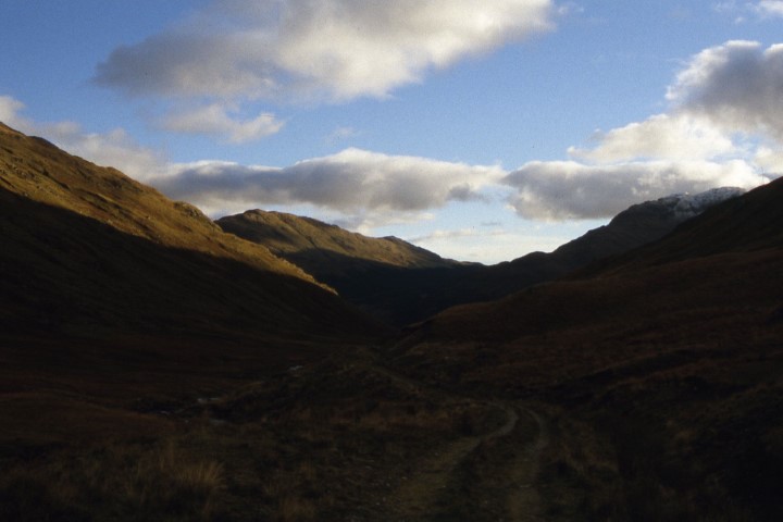
Heading back along the lonely Inverlochlarig Glen at the end of the day.

Group walk report 9th October from Darley Dale

The group on Oaker Hill towards the end of the walk.

For once it was a fine day but showers were forecast although as it turned out we appeared to be in a favoured location and missed all but one shower. From the car park at Darley Dale fourteen of us set out at 10am towards Churchtown in the bright sunshine. After walking across some squelchy fields we were soon at St Helen’s Church. Here I pointed out some features of interest. The churchyard is dominated by the Darley Yew, a 2000 year old yew tree with a massive girth. The church porch contains some fine Saxon coffin lids and further out in the churchyard we diverted to visit the grave of Sir Joshua Whitworth, inventor of the Whitworth Screw and rifle. The Whitworth thread was the world’s first national screw thread standard, devised and specified by Joseph Whitworth in 1841. Until then, the only standardization was what little had been done by individual people and companies, with some companies’ in-house standards spreading a bit within their industries.
Our walk continued beside the preserved Peak Railway which now runs between Matlock and Rowsley Stations. This railway line was once the mainline between London and Manchester. A field walk next led across the busy A6 and up to Two Dales. The village was once known as Toad Hole but a squeamish rector of Darley in the late 19th century insisted that the name should be changed to Two Dales.
The village is dominated by the former flax mill buildings. In the late 18th century, Daniel Dakeyne harnessed the stream that runs through Sydnope Dale to power his new flax mill. Daniel’s sons, Edward and James Dakeyne, designed a machine called the ‘Equilinium’ to prepare the flax for spinning and they went on to develop a hydraulic disc engine designed to make better use of the high-pressure water available at the mill. Given its tendency to groan and roar, the device was christened the ‘Romping Lion’ by local people. The large former flax factory, known as Ladygrove Mill, now provides accommodation for various businesses.
The deep wooded valley of Sydnope Dale was next followed with a morning break part way up. We later doubled back on a higher path before ascending to reach a road and soon entering the wooded summit of Matlock Moor. The walk over the top was easy to follow and on the descent we stopped within the woodlands for lunch.
Soon after lunch we emerged onto a track which we followed to the A632 and we continued along this road towards Matlock before branching off along Wellington Street to view the Old Tram Depot which is now a garage. The tramway was built to the Hydro Spa Hotels, bringing customers from the railway station near the River Derwent. One of the tramway’s directors, Job Smith got the idea for a steep-gradient tram for Matlock while in San Francisco in 1862. The original plan for the tramway was to run between Matlock Railway station and the Hydro Spa Hotels of Smedley’s and Rockside. The risk of flooding forced the terminus to be set up on Crown Square. Tram services started on 28 March 1893. It was the steepest tramway in the world on public roads, featuring a 1 in 5½ gradient. The tramcars had no independent power but were pulled by a cable situated below and between the tracks. The depot was situated on Rutland Street and contained a boiler and a stationary steam engine which pulled the cable and lifted the trams 300 feet up Bank Road. Fares used to be ‘Tuppence up, Penny Down’. Bank Road was not wide enough for two tracks, so a single track was used, with a passing place where the trams met. The up and down cables had to run in the same tube between the rails. The trams averaged 5½ mph, and had the advantage of the down-tram balancing the up-tram, and saving power in the Depot steam engine. A spare tram was kept in the Depot. In the 1920’s the tramway started to lose money and by 1927 the council decided to replace the tramway with motor bus operation, and tramway services ended on 30 September 1927. The Council agreed in February 1928 to put the tramway up for sale.
Rather than follow the road down through Matlock, we took a series of enclosed cobbled paths and later emerged in Hall Leys Park. At the northern end is located the restored tram shelter which has been relocated from Crown Square.
A brief but sharp shower came and went and we were soon ascending the Limestone Way on a steady slope across fields and later this was followed by a long descent to the village of Snitterton. I was keen to fine Magpie Cottage which was the place where William Wordsworth stayed and wrote his sonnet to Will Shore’s Tree. Ironically as we reached the road, the cottage was on our right. The road was followed through the village before taking another field path. We were soon ascending again and this time Oaker hill was our objective. Near the summit we stopped for an afternoon break before walking along the summit ridge which is dominated by the large sycamore tree. This lone tree tells the tale of two local brothers, Will and Tom Shore, who each planted a Sycamore tree atop the hill. The brothers quarrelled and went their separate ways; Will who stayed, flourished and prospered, whilst Tom who left, fell into penury and perished, and appropriately his tree withered and died. Hence for almost two hundred years, there has been a single Sycamore tree standing proud and alone on the summit of Oaker Hill. After visiting the trig point which included a group photograph we descended steeply down the grassy slope before following the village road through Darley dale back to the cars.

A shorter version of this walk will appear in the Macclesfield Express.

The following photographs were taken on the reconnoitre. (December 2018)

The waterfall above Potter Dam in Sydnope Dale.
The view towards Darley Dale from Farley Lane above Tax Farm.
One of the many forest rides on Farley Moor above Matlock.
One of the paths we walked crossing Matlock Moor.
On the summit of Oaker Hill. This photograph was taken just after sunsrise on a perfect winter’s morning with hardly a breath of air.

Conwy Coach Walk 28th September report

The strenuous walking group at Aber Falls.

Thirty eight, East Cheshire Ramblers recently went on a coach trip to Snowdonia where three walks were offered. The short and medium walks started in the picturesque and historic town of Conwy and ventured up onto Conwy Mountain to reach the Sychnant Pass to the west of the town. The groups were rewarded with fine views out over the Great Orme’s Head and beyond. Meanwhile a more strenuous walk of 12.5 miles was undertaken and started further west from the village of Abergwyngregyn and led by Rob Stevenson. In his capable hands we were on a steep ascent within minutes powering up on the C’aer Mynydd grassy path towards our key land mark; the Aber Falls (Rhaeadr-fawr) which proudly gush at the foothill of the Carneddau range. With much recent heavy rain the falls were an awesome sight.
Views of the whole area gradually opened up to us the higher we climbed. Across Conwy Bay we could see Puffin Island which still has the remains of a 12th Century Monastery, hence the island was formerly known as Priestholm Hermitage established around the 6th Century. The Island is now privately owned by the Baron Hill estate. The island of Anglesey and the Menai Strait was also visible even as a rain soaked mist blew over.
We had our morning break at the Aber Falls which plunges thunderously down 120 feet or so over a ledge of rock into the Afon Rhaeadr-fawr. We descended near the stream on the North Wales Path towards the Bont-Newydd Car Park passing many ancient ‘incisor’ standing stones including the remains of the Iron Age Coed Aber Roundhouse, a reminder of  the wealth enjoying the magical splendour of nature in shading times gone by.
Our second ascent brought us to our lunch stop high above the trees in peace and tranquility. Descending then ascending once more amid the heather and gorse we could see below us the town of Penmaenmawr. Our drop down into the town was past hedge rows heavy with sweet blackberries and too tempting not to try a few. Dry and thoroughly walked, we reached this well kept town where our challenging walk ended.

One of the many way-markers along the route.

Continue reading

Taking on The Gobbins

The entry to The Gobbins cliff path means squeezing through Wise’s Hole to start the adventure.

The website describes this walk as ‘The most dramatic walk in Europe’ and so here I was on a miserable July morning ready to take on the challenge. You can’t drive to the place and you are directed to the Visitor Centre some two miles away before kitting up with waterproof gear, sturdy boots and a hard hat. So on this miserable morning we started off with a safety briefing then taken by minibus to a cliff top road where the adventure began.
So where am I? Well this is one of Northern Ireland’s newest tourist attractions and is located on the Antrim coast some fifteen miles north of Belfast. The Gobbins is a path which literately clings to the cliff face along a scenic section of the Antrim coast and was created by the Irish railway engineer Berkeley Deane Wise and built as a tourist attraction and first opened to the public in 1902. Plans were quite ambitious with the original aim was to make it 3.25miles long but dogged with rock falls meant that the length of the walk had to be shortened and his bigger plan never came to fruition. In the early part of the 20th century it was a popular tourist attraction with many visitors from England and Scotland coming across to Larne on the steamer for the day but the railway company who operated the venture eventually ran into financial difficulties by the 1930’s and was eventually closed just prior to World War II. It reopened briefly after the war but again closed in 1954, that is until 2015 when funding from the local council and the EU carried out extensive work to reopen the path as a new tourist attraction with a difference. A series of walkways and bridges were built just above the high water line to provide the visitor with a safe route to explore this dramatic coastline.
Our group consisting of around fifteen of us plus a guide descended from the road via a steep driveway to the coast but today it is raining and not even Scotland could be seen. It might have been June but a bitter north easterly was blowing and it felt more like January. The Gobbins was entered via a hole cut in the rock face called Wise’s Eye. This was where fares were once collected. Over the next mile and a quarter we edged our way along the cliff face on a series of rock cut steps, bridges and walkways with the guide giving a potted history of the surroundings including flora and fauna and the interesting geology of the area which included places where we could see the rare Gobbinsite mineral which occurs only in a few places in the world. At one point the path disappeared into a sea cave and descended then ascended via a series of steps which took us down below sea level. In places the route of the old path could be seen and all of the original bridges had either been removed or had been washed away. The walk went a little further than a suspension bridge which spanned a watery chasm but today this is where our walk ended as there had been a recent rock fall a few days earlier and the last little part of the path was closed. It was now time to retrace our steps and squeeze past a couple of other parties on later tours.
Full details of the walk can be found on;- www.thegobbinscliffpath.com

The adventure begins along The Gobbins cliff path.

A typical section of the path.
Part of the original path from 1902.
Clinging to the cliff face on The gobbins cliff path.
Entering the sea cave.
A canopy along this section of the path to protect from rock falls.
The rare Gobbinsite mineral which only occurs a few places in the world.

Group long walk report 31st August

There was a healthy attendance for a recent walk from Monyash despite the weather forecast indicating a wet day.
Led by Graham Bothwell we set off at 10am southeast along the Limestone Way with the last of the sunshine soon disappearing by the time we reached Fern Dale. By now the weather was taking on a threatening look to the west as we continued via One Ash Grange Farm then crossing the wooded and deep Cales Dale. Ascending towards Calling Low, the rain started and so it was a stop to don waterproof gear but the rain didn’t really materialise. North of Calling Low we stopped for our morning break in the shelter of a tree belt.
Following more field paths and quiet lanes we descended to cross the River Lathkill at Coalpit Bridge where we intended to stop for lunch. By now the rain had set in and we retreated to the shelter of nearby woodland.
The first objective of the afternoon was to reach the village of Over Haddon by which time the skies were clearing to the west and at the village with the sun now returning it was time to get out of those waterproofs.
A sunny afternoon followed but the wind had freshened as we crossed fields passing to the north of Bole Hill to reach the Magpie Mine where we stopped for a short break. The final part of the walk was again across fields to reach Monyash where the group rounded off the day with tea and cakes in the Old Smithy Tearooms.

Graham leads the group at Fern Dale with the threat of wet weather just looming.

The cows are sitting down so it must mean rain is not far away.
The sunshine returns as the group heads out of Over Haddon.
Graham leading the group towards Bole Hill.