Discovering hidden gems in our industrial pass

Piccadilly Gardens, Manchester – rush hour near the start of my walk.

When I first had an idea of walk from Manchester to Bolton via the Irwell Valley I was a little bit dubious. Picking the right route which took me through the best bits needed some research and one or two parts didn’t have the best reputation but as we shall see, this turned out to be a really enjoyable walk.

It’s a fine autumn weekday morning with the feel that winter is not too far away and I am leaving early to catch the very overcrowded 8.02am train from Macclesfield to Manchester Piccadilly. How glad I am that I don’t have to commute every day. Twenty five minutes stood crammed into an aisle in a railway carriage pressed up against strangers who are engrossed in ‘The Metro’ or their mobile phone isn’t the way I like to travel.
I am glad to leave Piccadilly Station and march up through the centre of Manchester ‘pushed along’ with the commuters many of which are still glued to their mobile phones and are eager to get to their workplace. I briefly pause at Piccadilly Gardens which has more than its fair share of ‘cardboard box folk’ who are not going anywhere, before continuing my walk via Market Street and St Mary’s Gate then crossing the River Irwell into the much quieter Metropolitan Borough of Salford. I now have the pavements virtually to myself. Manchester had changed since the days of my work with tower cranes everywhere and yet I once felt quite at home in this environment.

The River Irwell by Peel Park, Salford. I walked the left bank on the river as I headed north.

In Salford, I continue on the Blackfriars Road to reach the nearside of Broughton Bridge where I turn left to join the Salford Trail, a 53 mile walking trail around the borough and stay with this along to the Adelphi Footbridge. I cross this and continue through a small housing estate to cross the River Irwell yet again. Heading north, I stay by the river and through the attractive Peel Park. Salford is looking up in my books. I stay with the western bank of the River Irwell up to Wallness Bridge where I have to cross briefly to the eastern bank for a couple of hundred yards before re-crossing at the next footbridge back to the western bank. Later I have to cross the busy Cromwell Road and afterwards I am pleased to see that I can stay by the river bank rather than trek through a housing estate to the west as my map indicates. The River Irwell now makes a big loop and the area has been landscaped into a large parkland with a low lying area forming some ponds and a wildlife haven. This area was once the site of the Manchester Racecourse. Horse racing was first recorded here in 1647 and over the centuries it was intermittently used as a racecourse until 1963.

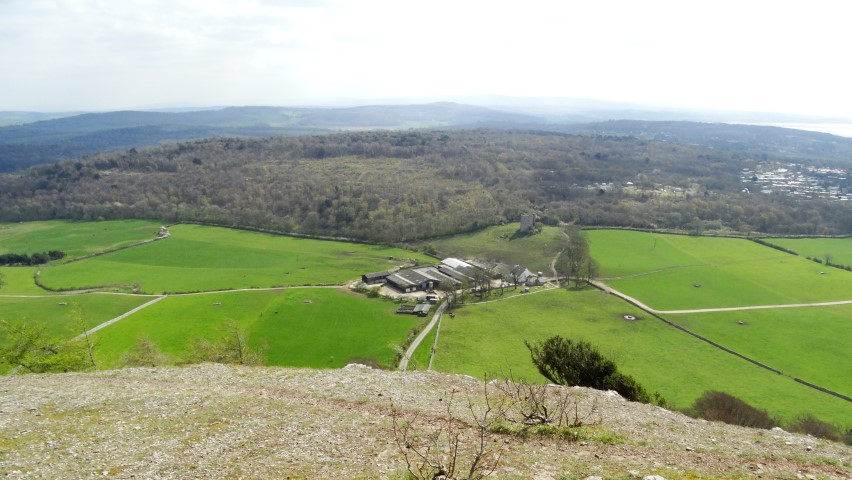
A distance view to Manchester from the site of the former Manchester Racecourse.

This section makes for some pleasant walking with the last of the morning mist over the river now burning off. To the southeast, is the hazy outline of Manchester City Centre with an array of tower cranes and new buildings. I note that Beetham’s Tower is no longer the tallest building in Manchester as the Deansgate Square South Tower had now reached its full height of 201 metres which from my later research means it is 32 metres higher than Beetham’s Tower. I cross the River Irwell yet again via a freshly painted green footbridge and soon skirt through Lower Kersal. I recall visiting this area many years ago to witness several high rise flats being demolished in a controlled explosion. Joining a path I reach a brightly painted red footbridge and again cross the River Irwell and take a path up the western bank. The autumn colours are giving a fine display as I head north through this fairly rural area. Later I walk alongside the large Agecroft Cemetery after which I cross the road by Agecroft Bridge and find a lone picnic bench for my morning break in the pleasant autumn sunshine.

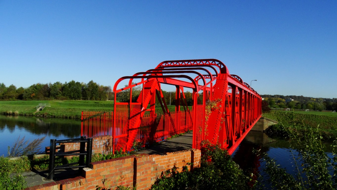
A colourful footbridge over the River Irwell at Charlestown, Salford.

Autumn colours displayed alongside the River Irwell at Agecroft Cemetery.

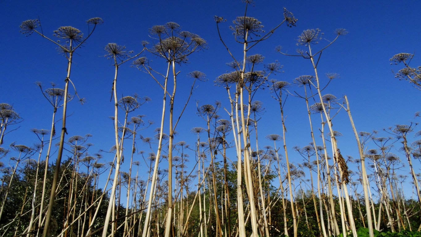
Land of the Giants! Giant hogweed set against a deep blue autumn sky was a common feature along this walk.

The countryside is becoming progressively more wooded as I continue alongside the riverbank but what is notable is the amount of towering giant hogweed which although has died bank makes for some interesting photographs against the deep blue sky. Around Clifton Junction there is some industry to my left mostly hidden among the trees and soon I find that I am following the course of the former Manchester, Bolton and Bury Canal. To start with, little of it is visible but I soon cross the River Irwell on the old Clifton Aqueduct which once carried the canal. North of the River Irwell I follow the course of a long gone railway which lead to a footbridge over the noisy M62 motorway. At this spot was once the site of the Molyneux Brow Railway Station on what was once the Accrington, Clifton and Colne railway line which ceased operations during 1931. I stay with the course of the former railway on the northern side before dropping down to a lower path bordering a long abandoned sewage farm now very overgrown and returning to nature. What surprises me next is that I come alongside a plant nursery tucked away and hemmed in beside the river on a sunny south facing bank. A little beyond I turn right onto a path again and now find evidence again of the former Manchester, Bolton and Bury Canal. Entering Ringley, I pass St Saviour’s Church and made down to take a look at the ancient Ringley Bridge which spans the River Irwell here. The bridge dates from 1677 and was built to replace an older wooden bridge which was swept away in floods in 1673. Nearby is an interesting clock tower which dates from 1625 and is now once more in working order.

The historic Ringley Bridge with the restored clock tower in the back ground.

Crossing the A667 I now follow the canal towpath for the next mile to the Prestolee Aqueduct. This proves to be an interesting section of the canal as it runs along the side of a steep hill side. Directly below is the community of Prestolee complete with church and mill which could pass as a scene one hundred years ago. Along this section, the towpath is in the process of being repaired. I next cross the ancient Prestolee Aqueduct which opened in 1793 and spans the River Irwell and just above it is the Prestolee Canal Staircase. The site has been cleared of vegetation to reveal the extensive stonework. Plans are afoot to restore this flight of locks. What is unusual is what work that has been carried out and several features made out of large scale Meccano have been constructed including a seat, picnic benches and largest of all a Meccano Bridge over the canal. It is a good spot to stop for lunch and a first for me to have lunch sat on a Meccano seat.

The historic Prestonlee Aqueduct, one or two historic aqueducts over the River Irwell in the area.

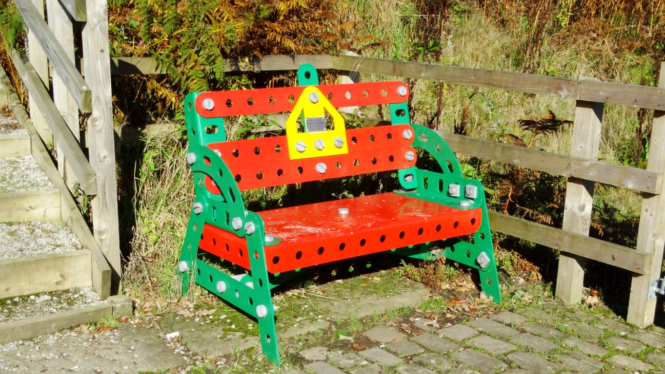
Not your usual lunch stop but this makes you look quite small!

This is the one I made earlier! Meccano Bridge at Nob End.

Autumn colours along the Manchester, Bolton & Bury Canal at Nob End.

My walk towards Bolton for now stays with the canal for the next mile which at first is covered with a thick carpet of green algae. Where the canal opens out, the autumn colours are very picturesque. I continue to cross the A6053 and to enter the Moses Gate Country Park. I want to branch off to see what is left of Darcy Lever Old Hall which was marked as italics on my Ordnance Survey Map. Prior to this site I walk through an area which warns of contaminated soil. Entering a group of farm buildings I can’t find any evidence of Darcy Lever Old Hall which I think had been demolished.
I cut through on some side paths and between houses to reach the path linking the former Liverpool, Bolton and Bury Railway Line. It has now been opened up as a footpath and crosses two railway viaducts, firstly the Darcy Lever Viaduct which spans the River Tonge and the B6209 and then the Burnden Viaduct which spans the River Croal and the busy A666 dual carriageway. Beyond, I join a side road then head up the B6356 to Bolton Station. I am in good time and could have spent an hour looking around the town but my feet are tired and the railway timetable shows a train is due for Manchester Piccadilly. I buy a ticket and am soon on my way back to Manchester for my onward journey home. It has been a good day out and with the sunny skies and the autumn colours has made this a very photographic walk coupled with the copious amounts of industrial archaeology.

Arnside Coach walks (Saturday June 8th) – What to see

Carnforth Station Clock (Long walk)
The long walk kicks off from Carnforth, a small railway town but today tourist flock to the Heritage Centre, situated in the railway station. The station was called ‘Milford Junction Station’ and became famous as the location for the classic 1945 film ‘Brief Encounter’ starring Celia Johnson and Trevor Howard. The famous clock which featured in the film has been restored and we will make a small detour to visit the station and view the clock.

The famous station clock on Carnforth Station.

Warton Old Rectory (Long Walk)
Under the care of English Heritage with free entry, Warton Old Rectory is now in a ruinous state. It was built in the early 14th century as the official residence of the rector for the nearby St Oswald’s Church. The building became ruinous early in the 18th century. It was not affected by the Dissolution of the Monasteries.

Warton Old Rectory

St Oswald’s Church (Long Walk)
This fine church dating from the 12th century dominates the village and is grade II listed. Extensive restoration was carried out on the building during the 15th and 16th centuries and the building has historical connections with the ancestors of George Washington, the first president of the United States. The church is well worth a visit and on my reconnoitre, taped background choral music made the building fell like a place of piece and sanctuary. One of the two village public houses is named ‘The George Washington’.

St Oswald’s Church at Warton.

Warton Crag (Long Walk)
This area is an extensively wooded and is a nature reserve. Our walk will wander among the moss covered limestone crags and will ascend to the summit which is crowned with a beacon and trig point at 163 metres. Nearby there are extensive views across Morecambe Bay and beyond. The crag is the Site of Special Scientific Interest and home to several rare plants and rich in butterflies including the rare pearl bordered fritillary and high brown fritillary. The area is a regular breeding site for peregrine falcons.

A panoramic view from Warton Crag across Morecambe Bay.

Leighton Moss (Long Walk)
We will pass alongside the southern fringe of the RSPB Leighton Moss Nature Reserve. The area has the largest reed beds in northwest England. One of its visitors is the Bittern. To our left the salt marsh provides a habitat for birds such as avocets.

Mine at Crag Foot (Long Walk)
All that is visible today is the chimney of the former haematite mine at Crag Foot. Even now there are rich deposits of iron ore in this area which weren’t mined because of poor prices. Iron ore was originally taken from the site by packhorse and after the coming of the railway age, the iron ore made its journey south from the nearby Silverdale Station. A small tower which we pass on the foreshore was built as a chimney in the 1780’s and its purpose was to smelt locally mined copper but the venture soon failed due to law suits. Today it is grade II listed.

The old chimney on the foreshore and part of a failed attempt to smelt copper in the area.

Warduck’s Wall and Jenny Brown’s Point (Long Walk)
If the tide is out on our visit, we will see the remains of Warduck’s Wall stretching out into Morecambe Bay. This was a venture to reclaim land between this area and Carnforth. Started in 1877, the project was abandoned in 1879.
Who was Jenny Brown? My research has shown that she was the daughter of a local farmer who had a farm at the point in the sixteen hundreds.
Not far from this spot was the scene of a disaster in 1894 when the pleasure yacht ‘Matchless’ capsized in rough weather with the loss of 25 persons. Most of them were on a day out from northern mill towns.

Jack Scout (Long Walk)
We will walk over this rocky limestone headland which has good views across Morecambe Bay. A small diversion off our route is ‘Giant’s Seat’, a large seat made out of limestone blocks. The area is owned by the National Trust.

Lindeth Tower, Silverdale (Long Walk)
Now used as a holiday let and private, we do pass and see this unusual Victorian folly. Built in 1842 by Preston banker Hesketh Fleetwood this is a three storied castellated tower and is grade II listed. In the 1840’s and 1850’s Elizabeth Gaskell stayed in the tower and wrote her novel ‘Ruth’ here.

Lindeth Tower – A Victorian folly is passed as we near Silverdale.

Silverdale Cove (Long Walk)
Our walk takes us along the coast and down to this attractive cove which is surrounded with limestone cliffs and Silverdale Cave.

A lovely stretch of coastline to follow as we descend towards Silverdale Cove.

Arnside Tower (Long, Medium and Short walks)
This substantial ruin is dominant on the skyline for the medium and short walking groups for some time before reaching it. This tall ruin dates from the latter part of the 15th century and is constructed of limestone rubble. The tower was originally five storeys high. Following a severe fire in 1602, the tower was restored and was in use up until the end of the 17th century after which is became ruinous. Around 1900 a large portion of the south wall collapsed and today despite it being grade II listed the tower is in a poor state of repair.
Just beyond the tower, all three groups will stop at Arnside Tower Farm Cafe where afternoon tea, coffee, cakes and locally made ice cream can be bought. (I can recommend the ice cream !)

Arnside Tower – a ruinous pele tower which dominates the skyline.

Arnside Knott (Long, Medium and Short Walks)
It is well worth the effort to ascend to the 159 metre summit. Although most of the hill is covered in woodland, there are excellent views just to the south east of the trig point over Arnside Tower and Morecambe Bay, whilst from the viewpoint on the northwest side of the hill you get a good view over the Kent Estuary and if clear you can pick out most of the main summits in the Lake District. The is a toposcope at this point.

On Arnside Knott and the view over Arnside Tower with Morecambe Bay beyond.

The view over the Kent Estuary from Arnside Knott. If it is clear, we should have a good view towards the Lake District.

Arnside (Long, Medium and Short Walks)
This is the finish point of our walk. The village has several cafe’s overlooking the Kent Estuary. The Kent Railway Viaduct built originally in 1857 and 505 metres long crosses the estuary just upstream from the village. We may be even lucky enough to see the ‘Arnside tidal bore’ which occurs just over an hour before high tide. A siren sounds twelve times to warn people to leave the beach prior to its arrival. In favourable conditions the bore can be up to a foot high and is caused by the tide rushing in over the vast expanse of sands.

Arnside and the view along the front which overlooks the Kent Estuary.

Milnthorpe (Medium walk)
This is the start point for the medium walk. Milnthorpe is a small market town on a busy crossroads and was once a port on the River Bela.

Dallam Tower (Medium Walk)
On the medium walk there is a good view to this grade I listed house. It is not usually open to the public and was built on the early 18th century on the site of an earlier building. Prior to that there was a pele tower on the site.

Dallam Tower and its parkland from the path across the Deer Park.

Dallam Deer Park (Medium walk)
The 190 acre deer park is passed through on the medium walk which gives mile of fine open parkland to walk through. Walkers should see the herd of fallow deer which freely roam the park. The walk passes close to the grade II listed deer shelter.

The grade II listed Deer Shelter and fallow deer in the park south of Milnthorpe.

Fairy Steps (Medium walk)
This is one of the highlights of this walk and a spot where you will need to squeeze through a narrow and polished limestone cleft. You will need to remove your rucksack for this. It is a right of way and old coffin route for burials heading for the church at Beetham as there was once no consecrated ground at Arnside. At one time coffins would need to be hauled up the cliff face. (A easier route has now been created little further south which avoids all difficulties). A local saying is that if you can negotiate Fairy Steps without touching the sides of the chasm then you will see a fairy! This may only be possible for a small child.

The narrow limestone cleft known as Fairy Steps.

Hazelslack Tower (Medium and Short Walks)
This is where both the medium and short walks converge but both will reach this point via different routes. Hazelslack Tower is a ruinous pele tower dating from the 14th century and is now attached to a farm. The building lies on private ground but there are excellent views from the path and lane nearby. Like Arnside Tower, Hazelslack Tower is a fortified tower house and many were built in the borders of northern England and southern Scotland and used as watch towers where signal fires could be lit a the garrison to warn of approaching danger.

The ruinous pele tower known as Hazelslack Tower.

Silverdale Moss (Medium and Short Walks)
Part of the Leighton Moss Nature reserve, both walks will have views to this area between Hazelslack Tower and passing beneath the railway.

As you can see, there is plenty to discover on all of these walks in this outstanding corner of England. There are still spaces on the coach for this walk so don’t miss this great opportunity to walk with friends on what we hope will be an excellent day out. See the E-mail sent out by East Cheshire Ramblers on May 1st giving full details of booking and pick up times from Macclesfield and Wilmslow.

Lincolnshire’s dish of the day.

Abandoned tropospheric scatter dishes at the former RAF Stenigot are a landmark for many miles around.

Lincolnshire is not all flat. Much of the county is gently undulating with the highest ground rising to around 550 feet above sea level on the Lincolnshire Wolds. The Wolds have been designated an area of outstanding natural beauty and this area of Eastern England has the highest land between East Yorkshire and Kent.

For this walk the weather couldn’t have been better with deep blue skies and strong September sunshine greeted my wife and me as we drove from our base in Lincoln across the Wolds to start our walk from the attractive village of Donington on Bain. We found parking in a cul de sac road south of the church and by mid morning we set off passing the small village church to join the Viking Way southwards. The Viking Way is a pleasant way marked 147 mile long trail running from Barton upon Humber to Oakham in Rutland which over the years I have walked in its entirety.

St Andrew’s Church at Donington on Bain dates from the 12th century.

The path south from the village was good and well defined as we followed field boundaries later joining a lane through Fox Covert. A left turn took us onto the aptly name Sandy Lane. At the end we turned right to follow a quiet road to reach the small isolated church at Stenigot, a grade II listed building. It was a left turn here to make a long ascent for Lincolnshire standards up through the hamlet of Stenigot.

The isolated church at Stenigot lies well away from the village.

At the top of the hill I went in search of a trig point which being at a road junction I thought would be an ‘easy bag’. It was anything but as I had to crawl under a hedge, over a fence into a field and back over the same fence to reach the well hidden trig point. With a few scratches to boot I had to return the same way. I had told my wife to wander on which she did and she was well down the lane by the time I emerged from my little adventure.

The 360 foot high former radar tower at RAF Stenigot is one of a few left that formed a vital link in Britains defence during WW2.

We had hoped to cut the corner by walking via the track passing Cold Harbour Farm but this was private and so we had to walk around via the roads to join our intended track leading to the ex RAF Base at Stenigot. The site is dominated by the disused 360 foot tall Stenigot Tower, now a grade two listed structure and was once one of a chain of radar towers used to detect incoming German aircraft during WWII. We stopped for a picnic in a field nearby with a view southwest across Lincolnshire. We spoke briefly to some residents living directly below the tower who surprisingly didn’t really know what the tower was for.

Taking the lane west, we soon turned right on a track north and soon made a diversion to visit some disused tropospheric scatter dishes, dumped in a corner of a field. Again these were a landmark for miles around and I was able to explore the dishes at close quarters. Back on the track north, my wife decided to head back to the car as we were quite close to our start point so I gave her instructions which way to go.

A peaceful September afternoon on the Viking Way at Biscathorpe. This is where the trail crosses the infant River Bain.

I for one wanted to explore Biscathorpe, a medieval deserted village a little further north and in any case it was too early in the afternoon to finish the walk. Going our separate ways I started meeting many other walkers and got chatting with one man when I crossed the next lane. The track ahead was most pleasant with wide views under a deep blue sky and it was just good to be out. Skirting around to the west I joined a lane down to Biscathorpe, a parish which today has only three buildings. A few people were out walking here. The lane ran west across a common area passing through a couple of fords with cows grazing in the area. I didn’t really have time to go to explore the mounds forming the medieval village but instead made a small diversion to visit the little church nearby. There are many deserted villages in the Lincolnshire Wolds but these villages didn’t disappear during the Black Death, but apparently it was due to the changes in agriculture practises as during the fifteen hundreds, sheep farming became more profitable over agriculture and was much less labour intensive resulting in many labourers moving away. My return to Donington on Bain was along the Viking Way which followed fairly closely to the infant River Bain and later along the road back to the car.

St Helen’s Church at Bicscathrope – one of only three buildings in this deserted medieval village

Mighty Nephin

The bulk of Nephin rises above the Plains of Mayo.

Nephin is a mountain few of us have heard of but rising above the Plains of County Mayo in the north west of Ireland, this hulk of a mountain is quite a feature in the surrounding area. With a prominence of 768 metres it is the highest standalone mountain in Ireland and yet it’s not even a ‘county top’ with that claim going to Mwellrea which is just eight metres higher.
Conical Nephin rises from the surrounding plain to 806 metres or 2646 feet in old money and its name translated means either ‘heavenly’ ‘sanctuary’ or ‘Finn’s Heaven’.
If the mountain was ‘plonked’ down in southeast England then it would probably have a cafe on the summit and a chairlift but here in Ireland only a sketchy path leads to the top.

‘A stile’ This looks promising. A sketchy path does go part way up the south western ridge. I had to negotiate getting through the forest below to get to this point.

Nephin has always been a mountain that I wanted to climb and being isolated from any other peak it would be idea for a half day walk. The only feasible way of climbing was to ascend and descend the same way. One big problem is that on most sides the mountain it is surrounded by farmland and so access is limited to a few points. I had done my research and found that the easiest way to climb the mountain was from a forestry track to the southwest.
Arriving fairly early, I parked in the secluded entrance to the forest track and after scaling a gate was soon heading up the easy forest track which abruptly ended at a clearing. I now had the hardest part of the walk by pushing my way through around two hundred yards of forest undergrowth and removing my rucksack to squeeze under tree branches. Having crossed a bard wire fence I was now on uneasy tussocky grass before negotiating a bank covered in bracken to gain the southwest ridge. I soon came across a fence and was pleased to see a stile so at least I was in the right area to climb the long southwest ridge. For now there wasn’t a path and any such sheep path tended to veer off along the southern side of the mountain. I toiled upward but at least the terrain was becoming easier. I did eventually find a path which petered out as I reached stonier ground. Despite no path from here onwards, the ridge was dotted with cairns. The early sunshine was disappearing and patches of cloud occasionally brushed the summit but thankfully this wasn’t an issue. One hour and forty five minutes I was on the 806 metre summit but timed it as cloud obscured the top briefly. I had donned my waterproof coat earlier as it was quite cold at this altitude, and I was even wishing I had brought gloves with me despite it being May.

The fine walk up the south western ridge does have a sketchy path and the views are opening out nicely.

Almost there as the terrain becomes stonier as I near the summit.

Clouds begin to brush the summit as I make the last few steps towards the trig point.

At the trig point I stopped for my morning break and surveyed the view but due to the cloud base being only just above the summit it was a bit limited and furthermore it wasn’t a place to while away the day as it was quite cold. Having taken a few photographs I set off down the way I had come. The weather was improving and cloud base lifting to reveal a most pleasant but cool day. I stayed with the path on the way down which became rather sketchy and decided to enter the forestry at a different point. This was not a wise move and I had to skirt around to my original upward route. I had expected to have seen other walkers on this fine Saturday but I reached the car without meeting anyone. It was still only 11.30am and I had been up and down inside 3 hours.

The view from the top and almost into the cloud.

Group walk report 21st March

The group on the Pilgrimage Trail.

By Paul Simms

The Peak Pilgrimage is a 39 mile long-distance footpath from the Church of the Holy Cross in Ilam to St Lawrence’s Church in the plague village of Eyam taking in ten other churches on the way. East Cheshire Ramblers are undertaking a series of circular walks to trace this pilgrimage route and we did the third of these recently.

A dozen Ramblers set off from Parsley Hay on the High Peak Trail on a fine, dry day. The High Peak Trail follows what was the Cromford & High Peak Railway. Built between 1825 and 1830 to join two important canals, this was one of the first railways in the world and initially used horses to pull the carriages on the flat sections and fixed steam engines to haul them up slopes. The line was finally closed in 1967 but 17 miles of it are now owned by the Peak District National Park.

We walked as far as Sparklow then to the delightful village of Monyash where there is the Bulls Head pub and a popular café in what was the village smithy. The cross on the village green is from 1340 when the village was granted a charter for a weekly market and the holes in the base are where local lead miners tested their drills after being sharpened by the smithy.

We visited St Leonard’s Church, built in 1100. Each church on the Peak Pilgrimage has a stamp and a bible verse that pilgrims can put in their guide book. From Monyash we left the Peak Pilgrimage route to make our way back to Parsley Hay via a short section of the Limestone Way, another long-distance path; this one being 46 miles through some of the most beautiful White Peak countryside.

Soon we entered the parish of Middleton &Smerrill, each entrance to which is marked by a boundary stone erected as a millennium project. We came upon the first of these, a large stone cube alone in a field, engraved “Bright Under Green Limestone Edges. With Queen Ann Lace and Cranesbill in her Hedges”. A little later we left the parish via a second boundary stone inscribed “Time, you old gipsy man / Will you not stay / Put up you caravan / Just for one day?”. And so back to our start point at Parsley Hay where the group visited the cafe.

Group walk report 27th March

‘Come on Graham, tell us where we’re going?’

Despite the promise of a fine week of weather, today didn’t quite live up to the expectations. A keen easterly wind greeted the group at Mam Nick Car Park. Under cloudy skies, our group of seventeen walkers led by Graham Bothwell set off for the short ascent to Mam Tor which today was not a place to linger. The summit which rises to 517 metres is crowned by a late Bronze Age hill fort and it is believed that it was occupied well into the Iron Age.
Heading northeast, our group continued along the good path to Hollins Cross which is the lowest point in the ridge between Mam Tor and Lose Hill. There was once a cross located here but it is believed to have disappeared over one hundred years ago.
The picnic benches at the National Park Centre at Edale was our intended morning break and to get there meant a long descent via field paths. At least at this spot there was more shelter from the wind.
From the village, the Pennine Way was followed west for the next mile before taking a path steeply up towards Grindslow Knoll. Some of the group diverted to take in the rocky summit of this spur on the southern edge of Kinder Scout whilst the rest of the group skirted to the west.
The lunch stop was taken at the sheltered spot at the upper reaches of Crowden Brook. Setting off once more our group now headed towards Swine’s Back via the maze of rocks known as Wool Packs. These curious gritstone rock outcrops litter the area and have been weathered into strange shapes.
To reach the western end of Rushup Edge our route took us over Brown Knoll. A good flag stoned path now aided our way across an area which can be boggy after wet weather. Turning east along Rushup Edge along the last leg of the walk we were now facing into the cold wind once more and along this section we did pass several rare White Park Cattle grazing.

The group gathered at Crowden Brook on Kinder Scout.

The back marker’s view as the group walks over Noe Stool on Kinder Scout.

Off to visit the ‘Bishop’

The Bishop Rock Lighthouse – a feat of Victorian engineering.

My son Stewart and I were half through a cooked breakfast towards the end of a week long holiday exploring almost every corner of the Isles of Scilly on what had been almost an exceptionally warm and sunny week. Staying at a B&B in Old Town on St Mary’s, the main island I was expecting a phone call, and sure enough, half way through my bacon and egg the call came through. I had been chosen to do a radio interview as ‘guest of the week’ on Radio Scilly of which I still have a copy of the recording. The three minute interview to what is probably quite a small audience mostly centred on our experiences during our stay on Scilly and one of the questions asked by the interviewer was ‘Which was my favourite island?’ Now that was a hard one to answer as each island had its own unique character. For example, Tresco was a neat and tidy island and was run as a business like manner and almost like a National Trust property and famed for its gardens whereas other islands were more natural and seemed that it was much harder to eke out a living insomuch that each islander had several jobs. In the end I had to settle for St Agnes as my favorite island as it was not only the most southwesterly but also the wildest and more exposed to those Atlantic gales.

I had planned our week carefully by visiting an island each day as the weather permitted and so St Agnes, Tresco, Bryher and St Martin took up four days which left two days to explore St Mary’s. The plan worked well with the first four days of almost perfect weather conditions of almost wall to wall sunshine before an Atlantic front made inroads in which we saw the other side of Scilly in rough weather. Even our ten mile walk around the coast of St Mary’s had to be curtailed due to driving rain and gales on the fifth day but we had a day in hand to complete this walk and anyway I wanted to explore some of the many archaeological remains in more depth.

So it was off to St Agnes on the first full day of our stay and with the weather perfect, it was an idea chance to combine our visit with a trip out to circumnavigate the
Bishop Rock Lighthouse. The day had dawned sunny and calm and just the weather for such a visit.

The Gilstone – one of the last scraps of land on the south western edge of The Scillies. It was scene of one of the worse naval disasters of the British Navy when in 1707 four ships commanded by Sir Cloudesley Shovell struck the rocks in this area and around 2000 lives were lost.

We had to go for it and set off for the short walk into Hugh Town, the island capitol after breakfast to board the almost full boat going out to the ‘Bishop’. We were away early and soon heading out passing the small uninhabited island of Annet then skirting the Western Rocks with the captain providing a history of the wildlife and ship wrecks. The Bishop Rock Lighthouse was always on the horizon, a sentinel in the bright morning sunshine. Having seen countless seals, puffins and the odd dolphin, we now made for the Bishop. As we drew closer I was impressed by the sheer size of this amazing feat of Victorian engineering. The present lighthouse was completed in 1858 and was built without loss of life and is 161 feet tall. Even today, being calm and sunny, there was a three metre swell around the rock. Having taken many photographs we set course for St Agnes and this would provide us with three hours to explore this small and most south westerly of the inhabited Isles of Scilly.

Heading out to the tiny island of Gugh across the tidal sandbar from St Agnes.

Lunch stop on Gugh. We were amazed by the intense strong sunlight on this day and a very quick way to get a tan.

In very strong sunshine we disembarked on St Agnes prior to lunch time. The neighbouring island of Gugh was still inked by the sand bar to St Agnes but we were told that the tide was coming in and by mid afternoon the sand bar would be covered. Stewart and I decided to head here first, and followed the narrow concrete road passing the popular Turk’s Head Pub to cross the sand bar. We walked around Gugh clockwise and on a rocky outcrop we stopped to have our picnic lunch. It was exceedingly bright with very strong sunlight and I had never known the light to be so strong. It also gave us a good tan by the end of the day. After lunch we continued our exploration of Gugh. There are two houses on the island and little else except for extensive areas of heather, low scrub and some pre-historical remains.

The Nag’s Head. There are many strange rock formations on the island. This is weathered granite which have been exposed to all the elements for thousands of years.

Pebble stacking seems to be a popular pastime on St Agnes. We saw hundreds of examples.

A lazy afternoon by the small lake at Periglis on St Agnes. The historic whitewashed lighthouse dominates the island.

Safely back across the tidal sand bar onto St Agnes we continued clockwise around the island. Paths were good as we headed to Wingletang Down at the southern end of the island. This area was more open with short cropped heather and many weird rock formations with fascinating names. These rocks are weathered granite and over millennium have been weathered into unusual shapes by the elements. The little beaches were good for building pebble towers of which I saw hundreds. A little off the path was a fascinating granite rock formation called the Nag’s Head. I made a short detour to photograph this. The ancient maze a little beyond around the coast was showing heavy signs of wear and tear. It wasn’t long before we reached Troy Town complete with its camp site. I would have imagined a bleak place in rough weather but today it was still and sunny. We ventured inside the island church at Lower Town beyond – a rather plain building with little interest. To the north, we walked beside Periglis, a large inlet before returning back to take the lane up to Middle Town, dominated by its gleaming white lighthouse. The lighthouse was one of the earliest in Britain but was still some five mile distance from Bishop Rock and was often too far away for ships to see before they foundered on the jagged rocks which surround the larger islands. A leisurely walk led us back down to the jetty. With some time to spare we headed to the Turk’s Head, Britain’s most south westerly pub for a cool drink in the beer garden before returning to the ferry to complete what had been a fairly magical day.

Rush hour on St Agnes – just another busy summer afternoon!

A day on Purple Mountain

The high point of the day, the 832 metre summit of Purple Mountain with a view towards the Macgillycuddy’s Reeks – but where is everyone!

Ranking the 21st highest mountain in Ireland, the 832 metre Purple Mountain is very much overshadowed by its more famous neighbour, the Macgillcuddy’s Reeks but an excursion to bag this peak plus it’s satellites is a rewarding day out. The mountain lies between Lough Leane and the deep gash known as The Gap of Dunloe. The mountain takes its name from the shivered slate found on its surface not that I had noticed any purple tinge.

From my base in Glengariff it was a fairly lengthy drive to get to the start point for this walk and I half expected the car park at Kate Kearney’s Cottage to be full. It was a nice surprise to see it far from full on this summer Saturday morning and furthermore there was free parking at this popular beauty spot – now you don’t see that in English Lake District! So who was this Kate Kearney that we have all heard about? My research showed that she was a local beauty who illegally distilled a poitin which was so strong it took seven times the amount of water to make it palatable. Poitin can only be made from cereals, grain, whey, sugar beet, molasses and potatoes.

Poitín was generally produced in remote rural areas, away from the interference of the law. A wash was created and fermented before the distillation began. Stills were often set up on land boundaries so the issue of ownership could be disputed. Prior to the introduction of bottled gas, the fire to heat the wash was provided by turf. Smoke was a giveaway for the Gardaí, so windy, broken weather was chosen to disperse the smoke. The still was heated and attended to for several days to allow the runs to go through. (source Wikipedia)

This path is marked on the Harvey’s Map but I just wondered how far it went. Thankfully it went almost all the way up the mountain.

On Tomies Mountain and the view towards Lough Leane. White fluffy clouds are mirrored off the lake surface on this still day.

It was 11am before I started out and I was pleased that I had done some research on how to gain access onto the mountain as there were houses and fields which bordered the eastern side of the road. With the help of my Harvey’s Map, a track ran east, a short distance north of Kate Kearney’s Cottage before turning south alongside a deer fence before abruptly stopping. Thankfully there was a reasonable path which carried on up the mountain side well beyond the point where it finished on the Harvey’s Map. I made steady progress up over the first spur before tackling Tomies Mountain 735 metres. Nearing its summit, I veered left to skirt around the base of a scree area. On the summit I stopped for lunch and had the place to myself. Lough Leane below me was like a mirror and little white clouds reflected off its surface.

On Tomies Mountain North and the view towards the Macgillycuddys Reeks

My route from Tomies Mountain North towards Purple Mountain. Easy high level walking.

Before heading for Purple Mountain I wanted to visit two satellite summits and first headed over the slightly higher Tomies South 757 metres before heading out and back eastwards to Shehy Mountain 762 metres. Passing Tomies South again I joined the ridge up to the top of Purple Mountain 832 metres. Being a Saturday, I was surprised to see no one around as I expected this to be a popular walk. By now it had clouded up and was turning out quite a dull afternoon but at least the cloud base was well above all the summits.
From the three cairns on the summit of Purple Mountain a stony path led southwest descending over a rocky lower summit then descending steeply down a steep rocky slope to the small Glas Lough. I was glad of the path beyond through this extremely rocky terrain and a further descent took me to the top of the Gap of Dunloe.

The steep way down towards the top of The Gap of Dunloe. Thankfully, I had a path to follow.

The road walk back can be the less interesting part of the walk but not in this case. In many places the road squeezes between house size boulders with towering cliffs above on either side.

I had always thought that the road through the gap was not open to the traffic and only used by jaunting cars but I noted that there were no restrictions to ordinary traffic.
I paused at the top of this impressive pass before heading north on the long winding road which descended through quite spectacular scenery. Often, the road walk back can be a bit mundane but not on this occasion. There were towering cliffs either side with rock falls and house size boulders littering the steep hillsides. Several people were out walking the road and thankfully there was little traffic. I was passed by a few jaunting cars as I headed back to Kate Kearney’s Cottage and reached my car by late afternoon. The convenient Coffee Pot Cafe was still serving hot meals and so I finished up in there for my main meal of the day.

The view up through The Gap of Dunloe from Black Lake. I was now nearing the end of a fantastic walk.

Group walk report 9th March

A happy bunch of slightly damp ramblers at Werneth Low

Despite the promise of dreadful weather, a group of eleven East Cheshire Ramblers set out for a walk from the Broadbottom/Chisworth border. Our route soon reached the Broad Mills Heritage Site and took us along the River Etherow. This was the location of textile mill buildings built and developed from 1802, and by 1824 included three large cotton spinning mills. The mills closed in 1860, re-opening in 1870 under different ownership for textile production and closing again in the late 1920’s. We followed the river in a south-westerly direction, until reaching a footbridge, here we left the river bank, to pick up the Cown Edge Way, eventually reaching Werneth Low Country Park, where we had our coffee break, whilst enjoying the stunning views. After our refreshments, we continued alongside the golf course before descending steadily to Etherow Country Park, where we re-joined the river from which the park gets its name. The park originated in the1820’s then in 1968 it became one of England’s first country parks, and now attracts over a quarter million visitors a year. Passing the weir, our path took us uphill again, through Ernocroft Wood to reach and cross the Glossop Road. We continued in a southerly direction along a path which is often muddy, but today, as hardcore had been laid making it was easier to navigate. Continuing our route via Ernocroft and Gird Lane, we reached a field path which took us to the Cown Edge Way again. This is a 28 mile generally U-shaped path, which starts in Hazel Grove and ends in Gee Cross. It takes in stretches of the Macclesfield and Peak Forest Canals before ascending to Cown Edge, which was our destination. On our way up, we passed some stones, which are known as Robin Hood’s Picking Rods. They are believed to be the bases of double cross shafts dating to the 9th century. They are used as boundary markers. According to tradition Robin Hood bent his bow between the rods. From here, it was an easy climb to the top, where again we were able to enjoy excellent views. Finally, we descended gradually via Hargate Hill, crossing the Glossop Road again and joining the Trans Pennine Trail for a short time to arrive back at our start point. A final de-brief was held over tea and cakes at Lymefield Garden Centre.

Our morning break on Werneth Low moments before the rain and ice pellets started.

Waiting for the rear of the party to catch up in Etherow Country Park.


Weir on the River Etherow in Etherow Country Park.


Robin Hood’s Picking Rods often passed on are walks in the area.


Cown Edge in not the best of weather. We ddin’t time the walk well over the summit as driving rain set in for awhile.

Group walk report 27th February

Pausing on a footbridge in the Goyt Valley during the warm spell of weather in February.

By Ann Thompson

A group of 12 ramblers set off from Pym Chair on a bright sunny morning with a cool breeze which turned into a very warm day. Those in shorts were correctly clad and others soon peeled off gaiters, fleeces etc. Pym chair is so named as there was until 1838 a rock chair at the location. Unfortunately it was broken up and used to mend the road. One explanation for the name is that Pym was a highwayman using the chair to look for packhorses laden with purchases and then send his men to plunder them.
The walk set off along the ridge to Windgather Rocks where we went below the rocks to look for cross bedding and other geological structures. Disappointingly there were no rock climbers so early in the morning. On descending into the Goyt valley, we passed two reservoirs. The first, Fernilee, was built in 1938, and beneath the water near to the dam are remains of a gunpowder store. The nearby mill suppling gunpowder for use against the Spanish Armada. The second reservoir, Errwood, was built in 1967 to supply the developing towns and villages in the area.
Having crossed the dam wall the walk continued south above the reservoir and then over high moor with plenty of shooting butts descending to cross Goyt’s Clough and rise steeply to reach Shining Tor at 559m. It was then a 2 mile ridge walk over Cats Tor back to Pym Chair. A superb day with spectacular views both in the distance and of the reservoirs.