
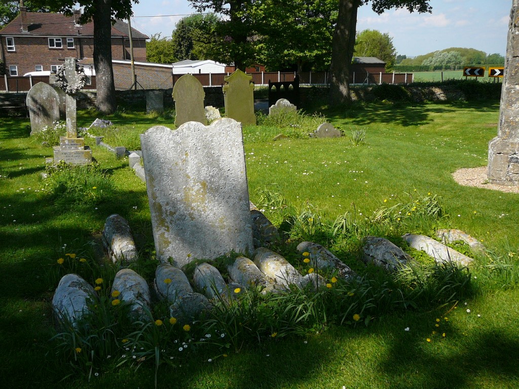
Often referred to as ‘Pip’s Graves’, these small barrel graves are located in Cooling churchyard.
Most of us have never heard of the Hoo Peninsula or even where it is. It’s not a place exactly on the tourist map and yet it is where one of Britain’s most prolific writers took inspiration from one of the best known books ever written.
Lying between the River Thames and the River Medway, the Hoo Peninsula consists of a low line of hills bordered by low lying marshes and terminating at the oil refinery on the Isle of Grain. Only one main road penetrates the area and this heads directly to the Isle of Grain. There are a few villages located above the marshes and many of these communities have seen recent expansion but still retain some old and fascinating churches. The marshes are devoid of any civilisation with several square miles of pastures and a maze of drainage ditches.
Charles Dicken’s took inspiration from this area in writing the novel Great Expectations. The story begins at the isolated village of Cooling in the winter of 1812 with the main character Pip fixated over the barrel graves of his parents, brothers and sisters which he is confronted by the escaped convict Magwitch. The setting of the story is very much on the bleak, cold and foggy Kent marshes in mid winter with prison ships moored in the nearby Thames. The graves can be seen today in Cooling churchyard and are often referred to as ‘Pips Graves’. The line of small barrel graves dating from the period between 1771 and 1779 belong to the young children of the Comport and Baker families who lived nearby with the oldest child dying aged no more than seventeen months. The deaths were probably attributed to malaria. Today, one could imagine this location being cold and bleak but for this visit it is a fine and sunny May morning.
For this family walk we are setting out from the nearby village of High Halstow which unlike Cooling has seen some expansion in recent years. With a picnic lunch at the start this will be a walk down onto the Kent Marshes but our walks gets off to a bad start as we manage to lose the path on the thickly wooded Northward Hill and have to back track. Northward Hill is a nature reserve and despite its modest height there is the odd vantage point which affords views towards London. It feels strange to see the towers of Canary Wharf rising shimmering in the distance above the vast openness of the Kent Marshes on this fine day of early summer. We do eventually pick up the Saxon Shore Way over Northward Hill which is a much better path. A left turn later takes us on a field path down to Decoy Farm and here we joined a lane for awhile to get to Swigshole, the last farm. Beyond we are on the Kent Marshes and beyond, the River Thames so it seems unreal when we see a large ship plying the hidden waters across the marshes as it appears to be sailing across dry land. A good track leads out to Egypt Bay on the Thames Estuary and this little bay has a surprise for us. The upper part forms a fine shell beach making it feel rather out of place but the downside is the amount of flotsam along the high tide mark.

Not exactly the Mediterranean but at least Egypt Bay you will have to yourself even on a fine day.

Walking the sea bank alongside the River Thames.
The origin of the place name Egypt Bay is unclear but one theory was that the area once traded with the eastern Mediterranean around Egypt as Phoenician artefacts have been found in this part of Kent. Further down the beach the shell sand is replaced by typical Thames mud. We take a rest here on the embankment looking across to the Essex side of the Thames including Canvey Island and the hills around Hadleigh. We follow the embankment east now for a mile and a half to reach St Mary’s Bay. It seems strange to be in such a remote area yet within sight of London. Like Egypt Bay, St Mary’s Bay also has a shell beach but again, the down side along this stretch of coast was the amount of flotsam washed up to the high tide mark. Turning inland we now head towards the village of St Mary’s Hoo, initially on a good track across the marshes before gradually ascending across fields. The village stands isolated above the marshes and has some old buildings.

Like Egypt Bay, St Mary’s Bay has shell sands but not the sort of place to go for a paddle.

‘Sailing across the fields’. This large ship is outward bound towards the Thames Estuary.

Time to leave the marshes and head towards the higher ground at St Mary’s Hoo.
For the last leg of the walk we cross higher ground with large arable fields on the return to High Halstow.

The last leg looking back towards St Mary’s Hoo and its historic church.