Harrop Brook Bridge

Historic Footbridge Saved

An iconic stone arch footbridge across Harrop Brook near Bollington has been saved from collapse thanks, in part, to a donation by East Cheshire Ramblers. The bridge was probably built in Victorian times. It is in the Peak District National Park and is on the Gritstone trail, a popular long distance trail stretching from Disley all the way south to Kidsgrove.

Over the years the bridge supports have been eroded by the force of the Harrop Brook and the bridge is in danger of collapse. However, the cost of restoration far exceeded the cost of replacing it with a ‘standard’ timber footbridge. East Cheshire Ramblers considered that it would be tragic to lose this unique little structure and have pledged £500 towards the cost of restoration. CEC obtained similar donations from Pott Shigley, Bollington and Rainow Parish Councils and also from the Peak and Northern Footpaths Society. The repairs are in hand and due for completion by summer 2019.

This is an example of the work of the Footpaths Committee of East Cheshire Ramblers whose members regularly liaise with the Public Rights of Way Unit of Cheshire East Council. The Footpaths Committee monitor an area stretching from Disley and Poynton in the north to Wincle in the south. The Committee strives to ensure that all the public footpaths in this area of East Cheshire are in good order.

Harrop Brook Bridge showing a gap in the stonework at the right hand side of the photograph.

ECR Coach Trip to Arnside

A coach load of ECR members enjoyed a coach trip to the Arnside area on Morecambe Bay on a rainy day in June. Despite a dire forecast the rain never amounted to much more than a heavy drizzle and had almost stopped by the time we set off back home.
The day got off to an unusual start when we stopped to pick up one of our members in Macclesfield and had to repel boarders who had mistaken our coach for theirs and were insistently trying to join us. We shall never know if they would have enjoyed a day walking in Cumbria.
All three of our walks ended by walking over Arnside Knott and down into Arnside village. There were surprisingly good views of the Kent Estuary and the southern Lake District from the top. One disappointment was that the promised stop for ice cream before the ascent was not possible because the tea shop was closed: perhaps the weather was too bad for even hardy Cumbrian farmers.
The short walk was led by Ruth Harrison and started a mile or so along the coast from Arnside at Sandside heading inland through the village streets and over fields to the peel (or pele?) tower at Hazelslack. The route then took us round Silverdale Moss across surprisingly dry fields to a pleasant walk through woodland to the ruin of Arnside Tower and its closed café. This led to the only serious ascent of the day through the woods surrounding the Knott. The Knott has superb views over the estuary, the Lakeland hills and back towards the Tower. The walk finished with a descent to Arnside and its welcoming cafés, most of which were actually open.

Short walkers on Arnside Knott

Hazelslack Tower

Arnside Tower

The medium walk was led by Steve Hull and started near the fire station in Milnthorpe walking across a playing field by the River Bela to avoid the narrow village streets. We made a sharp turn to cross the river near to Dallam Tower (another peel tower) and then walked across the deer park with its many deer calves. After passing a deer shelter and two mills – one for making specialised paper and one an ancient corn mill – we took a path overgrown cow parsley which proved to be the wettest part of the day. The route then went up through woods to the Fairy Steps. None of our party took up the challenge of descending the steps. The descent to Hazelslack was taken slowly across slippery limestone where we joined the route of the short walk. We followed that route until Arnside Knott, from where we descended to walk along the coast for the last half mile into Arnside. On top of the Knott we heard the siren warning of the approaching bore across Morecambe Bay which can be very dangerous for the unwary.

Medium walkers on Arnside Knott with Arnside Tower in the background

Arnside Viaduct from the Knott
The long walk, led by Colin Park,started close to Carnforth station where the 1945 film ‘Brief Encounter’ was filmed and then proceeded via Warton village with its ruined old rectory to Warton Crag which with its wooded limestone country required some complicated navigation. From the crag the walk continued through Leighton Moss Nature Reserve down to the coast at Crag Foot and then along the coast via Jenny Brown’s Point and Jack Scout to the west of Silverdale. After taking the coast route round Arnside Park the party ascended Arnside Knott and so back to the coach at Arnside.

Near Jenny Brown’s Point on the long walk (Warduck’s Wall)

Coastal viewSilverdale Cove

Text: Steve Hull
Photos: Jenny Bordoli, Maggie Swindells, Sylvia Hill

Committee Meeting Minutes April 25th

East Cheshire Ramblers Group Minutes of the Committee meeting held on 25th April 2019

1. Present

Jane Gay – Chair

Sue Munslow – Membership Secretary

Kathryn Carty

Maggie Swindells – Social and Events Secretary

Keith Anderson

Adrian Flinn – Secretary

Neil Collie (for item 1 only)

Apologies: Colin Finlayson (Treasurer) and

Dave Barraclough (Footpath Committee Chairman)

1. RA General Council 2019 held in Manchester on 13/14th April . Feedback was given by Neil Collie who attended this meeting on behalf of the Area since the Congleton Group (whose turn was to represent the 3 groups in

1

our area) were unable to attend (notes prepared by Neil are attached in Appendix 1). Key points relevant to ECR group were:

a) Priority to address the slow decline in membership. The Committee considered different ways that ECR can reach out and attract new members in our area. After considering several options (including publicity) it was agreed to explore links with other walkers (who may walk alone or in small groups) to explain the campaigning work of the Ramblers Association (RA) at a national level and the local work of ECR members inspecting and maintaining the local network of footpaths. This may encourage other walkers to join and support the RA. Action: All Committee members will attempt to make links with other walkers in our area and report back at the next meeting.

b) the work of our Footpath Committee will be explained in an article to be posted in our website for information to the wider membership/audience one of our key activity that benefits everyone walking in our patch

2

whether an RA member or not. Action: Neil Collie

The Committee thanked Neil .

2. Matters arising from last meeting
2.1 Walk Leaders Training: arranged to take

place on 4 July (full with a waiting list).

2.2 Rainow FP28 (Harrop Brook bridge):

ECR contribution was actioned and we are now awaiting notification from Cheshire East Council (Evan Pedley) as to when the installation will commence so that we can take photos for our own publicity (see also 1 (a) above)

2.3 Lost Ways: No progress to report. Action: Colin Finlayson to report at next meeting on current situation and progress.

2.4 RA membership fees: the proposed motion to RA General Council 2019 regarding the freezing of subscriptions which could potentially help to entice more walkers joining the RA was circulated for discussion with the other Cheshire East groups (see also 1(a) above). It gained some support but not

3

unanimous so it was not submitted to Central Office.

2.5 Frequently asked questions for new Walk Leaders: the Q&A is ready be posted in the website asap. (Post meeting note – the Q&A is available in the website now).

3. New Issues

3.1 Walk Register App: to be reviewed when version 2 of the App is released in the Autumn by RA.

3.2 Front cover to Ò6 monthÓ programme:

not an issue as most of the information that was proposed to be incorporated on a front page can be found in the website under the tab ÒAboutÓ.

4. Walks Programme

4.1 Routinely request a short report from Walk Coordinators on any significant points: this proposal was rejected by the Committee (put forward by Dave Barraclough) as it was felt the this would be an unnecessary burden placed on the Coordinators and, in any event, if a Coordinator needs to raise any issue can do so

4

by approaching a Committee member as they do now.

5. Reports from Officers
5. 1 Chair
Report in Appendix 2. Noted.

Several names of experienced Walk Leaders were put forward as they may be willing to help with the training course (see item 2.1 above).

The Social Secretary will be given access to the website for posting information. The Chair and Secretary have access already.

5.2 Treasurer

Report in Appendix 3. Noted

5.3 Membership

Report in Appendix 4. Noted.

The new member Welcome Letter has been updated with the latest feedback from the Committee. This letter contains useful information to access the available resources provided by ECR and RA in their website. It was agreed to attach this letter to the minutes so

5

that existing members have access to this very useful information as well (see Appendix 5)

5.4 Social & Events

Report in Appendix 6. Noted.

5.5 Footpaths

Report in Appendix 7. Noted.

5.6 Publicity

No report. The weekly walk reports are going into the Macclesfield Express on a regular basis.

6. Any other Business

6.1 Area Leadership Day – Crewe – Friday 26th April: this meeting was organized by the RA Northern Area Support Officer (Diane Simcoe) to give volunteers in the ECR and the other two groups in our area involved in Committee and other lead activities to meet area support staff and a Ramblers director and have an opportunity to network and learn about new staff and developments at Central Office. Unfortunately the Committee received notice of this meeting less than 24 hrs. of the date and no

6

one in the Committee could attend as they had other commitments. Unfortunately, in addition, the notice was not sent to all the relevant people in our Committee. Action: Jane Gay will contact Diane Simcoe to ensure that she has all the relevant names/contact details in our Committee and explain the lack of participants from ECR.

6.2 Countryside Access Forum: John Handley has resigned and we recognize his contribution and thank him for all the work he has done on ECR behalf. Morris Palin is still a member of this forum.

6.3 Safeguarding information : will be added as an item for the agenda of our next meeting. Action: Adrian Flinn and Maggie Swindells will provide background information before the next meeting

Date of next meeting

Monday 24th June 2019 at 1.30 pm at Chair house

Adrian Flinn – Secretary (29.4.2019) 7

APPENDIX 1 Reflections on General Council, Manchester 2019

A highly organised and slick event. The staff, Trustees and the volunteers for the event were all wearing the same T shirts emphasising the One -Team-Approach. All the staff and Trustees sat along the front row of the auditorium. Senior staff members were called upon in turn to give their part of the presentation supported by the Trustee who had been involved with that topic.

‘Van’ (Vanessa) Griffiths the new Chief Executive appointed 2 years ago, emphasised we are all One Team, no more divisions, but embracing change and moving forward together. We were reminded that we didn’t belong to a walking club but to a movement. The Ramblers organisation is aspiring to become the ‘Go-To’ place for walking. Central office is listening and new methods would be modified in light of feedback. Local successes need to be shared with the Trustees and Central Office (CO).

First priority was to address the slow decline in membership over the last 15 years and there was a promise to achieve membership growth ‘within 3 years’. We needed to be a welcoming organisation reaching out to new members, and recognising that the majority of members do not go on organised walks.

The new IT Director spoke lucidly about the ‘Digital and Data Transformation’ going on and spoke about her priority to make it easier for everyone, The vision included new phone apps that would enhance your walking experience. The ambition was to build a system as good as Trip Adviser that would advise you about the local area –even tell you which path to take to avoid a muddy section? 5 databases have been combined into one and the new digital dashboard is there to be used. Walk leaders would zapp members cards at the start of walks so that CO could collect all sorts of lovely data about what we were doing. This data is useful to justify support from funders. In answer to a question, the director said that if ‘someone really didn’t want to be zapped it would not be compulsory’. More on the General Data Protection Regulations (GDPR) later…

The finances are in good order. £3.9 million surplus this year. But legacies contributed £1.6m and are notoriously unreliable. £250,000 is earmarked annually for legal fees opposing footpath changes – is this sufficient?

I didn’t stay for the dinner, apparently there was a quiz all about Manchester…. and guess which table won…… Greater Manchester & High Peak Area!

On the second day, there was the election of three new Trustees. All the candidates were passionate about walking….all embraced change and most were experienced in change management and knew it was difficult……

8

Next was the consideration of the motions that had been put forward. Only seven this year including one to rename the Agenda Committee to be the Motions Review Committee. Did it need to be debated?……. Yes it did!
Next up was GDPR and a motion asking the Trustees to acknowledge that locally held databases were OK. Apparently not, and a Trustee threatened us with a one million euro (or was it ten million euro?) fine. CO have it in hand with a dashboard app where areas and groups will be able to access the information they need? No doubt our membership secretary has all this in hand.

Third was a motion asking for an increase in publicity for the work ‘we do in improving the quality of the Public Rights of Way and in campaigning for increased access’ We were told that two new posts have been created for two years: Local Advocacy Advisors, one in the south and one in the north, who would help with this. Fourth motion was asking for school packs to help recruit young people (and their parents) ‘who then stay with us for all their lives’.
Fifth motion was bemoaning the change of Policy by the Environment Agency (EA) towards maintenance of river banks where they impinge on rights of way. Apparently CO had been re-assured by the EA chief exec there was no change in policy with respect to river banks ‘on their land’. But most problems occurr not on EA land …….?
Sixth motion was on national planning guidance on green spaces and rights of way. Laudable stuff to press for strengthened guidance….
Seventh motion was an entertaining speaker on a motion to create a diverse and representative General Council (GC). She argued very persuasively that diverse organisations make better decisions and asked that Areas examine how they select there representatives to GC. Were there actual or perceived barriers that made participation by women more difficult? The Trustees to report back to 2020 GC which is to be held in Avon.
I can’t remember which motions were carried or defeated (except the first which, thankfully, was passed unanimously) but all the details of the motions and much more is on the Ramblers website.

Overall impression? For me it was exhausting (even without the evening dinner) but there is no doubt we are on the move and led by an impressive team – none of whom seemed to have been in post for more than one or possibly two years. Will the same team be there in five years time when it will be possible to assess the effectiveness of the changes which we are being asked to embrace? It was inspiring, almost evangelical at times. It is more than about led walks……. we are all One Team working together, and don’t forget the main message…. more members, more members, more members.

One final thought, are we missing out on conversations and consultations with CO as we have no area representatives? Are other areas better informed than we are? Maybe, just maybe, it is time to consider having an Area Chair – even if a ‘virtual’ one?

NSC 16.04.19

9

APPENDIX 2

Well, itÕs been a busy time and IÕve done little walking!!

I have met with Maggie a couple of times re the Social SecretaryÕs role and feel very confident that she is going to do an excellent job.

I have attended a meeting at MelanieÕs house about walk leading for the Ilkly weekend away. I have attended the meal at the Gurkha restaurant in Macclesfield. I also attended the talk given by Duncan which was brilliantly supported and was MaggieÕs first event.

Cheshire East area volunteered to trial the national first aid training and we were selected. Eventually the date of the 20th of March was agreed. There were 11 places available in the morning and the same number in the afternoon. I advertised the course and had no problem filling our allotted 7 places. Eventually we had seven people who attended in the morning and three in the afternoon. We also have a waiting list of
2/3 people who would like to attend the next course we run. The course was excellent and I think everybody who went learnt something and came away feeling more confident about dealing with a serious emergency. This, I think, could become part of our annual program. John Kummer from North and Mid Cheshire wanted to send 2 participants so maybe we could turn to them if we were short of attendees.

I have met with Gillian Kay and Sue Munslow to organise the walk leader training. Much communication has gone on via email and we eventually have a program which is going to run on the 4th of July. I have two volunteers prepared to help at the moment. They are Michael Murphy and David Gylee. Frank and I are also prepared to help but we do need at least two more people so please rack your brainÔs and ask around amongst experienced leaders. I advertised the course on the 29th of March at about 5 pm and by the end of the evening I had 11 candidates with 6 reserves! Many of whom are new to me and hopefully also reasonably new to the Ramblers.

I have met with Roger on a couple of occasions to discuss the website. As a result of these meetings Frank is taking over circulating emails and I am posting information on the website. This is a short term solution and once we are both comfortable with the roles we will be looking for other people to take over. This must have happened by the time we go to Australia in September as the website does peculiar things due to the time difference!! Roger would like the committee to be able to post information onto the website. I feel that Maggie should certainly have access and anybody else who would like to. The more the merrier!

I will make it clear to members, if necessary, that information should not go out via the mid week coordinators as this causes confusion and results in some people receiving large number of emails about the same event.

It was brilliant that Neil Collie offered to attend conference, initially as an observer but when we realised that the area was not going to be represented he went as a delegate. He is attending our next meeting and I have circulated his report. Can I just say a massive massive thank you to Neil for attending.

We are still making a massive effort to ensure that everybody is carrying an ICE card. I think we probably need to circulate details of how to have your medical information on your phone.

I have been looking at the ramblers app for registering attendees at walks. I think one of the issues is that if the walk Is not on the national website then it doesnÕt appear on your phone. Perhaps a few of us could have a crack at this and see what we think.

I will handout a sheet at the meeting about contact numbers for Ramblers and also about grading walks. I think basically we are okay but maybe we need to re-circulate the information about our walks, the length and the grade perhaps need explaining on each 6 month program.

See you on Thursday Jane

10

APPENDIX 3

11

Membership report. April Total membership is steady Jan 576
Feb 577
March 575
April. 575

APPENDIX 4

Changes to ÔWelcome LetterÕ (already circulated) to encourage ICE details to be recorded on phone and 100 more ICE cards arrived to be given out by walk leaders.

Feedback already received ……also to include information on stroller walks and for new members to send emails addresses to walk leaders .

APPENDIX 5

Dear updated welcome letter

The Ramblers Central Office has recently sent me details of your new membership and I welcome you to our East Cheshire group. I hope you will enjoy walking with us in the future.
We offer a full programme of walks throughout the year, both at weekends (mainly Saturdays) and during the week on Tuesdays, Wednesday, Thursdays and Friday strollers. Walks are categorised as long, medium, short and stroller. The majority take place in Cheshire, Derbyshire and the Peak District, with some in Staffordshire.

Details of the walks for the week ahead can be found on the front news and information page of the East Cheshire Ramblers website- www.ramblerseastcheshire.org.uk . The walks are usually posted on the website from a week to a few days before they are due to take place. If bad weather is forecast it is advisable to check the website in case the walk has been cancelled or there is a new route and starting point. By clicking on the Full Programme above the Current Programme information and dates for weekend walks over the next six months will be displayed. Also, to be found on the website is information about the groupÕs social events, coach trips and walking weekends away.

Information about mid-week walks can be sent directly to your email address if you so require. If you would like to receive this information then please contact me on the walks you are interested in.

Long walks are 11 miles and over, but only very rarely go beyond 15 miles. Medium walks are between 8 and 10 miles, while short walks are between 4 and 7 miles, but usually averaging between 5 and 6.5 miles. All the walks are graded for their difficulty. These grades are easy, moderate, moderate/strenuous and, very occasionally, strenuous. An easy walk would be short in length with only minimal gradients. Moderate walks are of medium length involving some hill climbing. A moderate / strenuous walk would cover a longer distance combined with a number of steep ascents and descents.

Nearly every walk starts at 10am. We are disciplined at starting walks promptly at this time. It is necessary, therefore, to reach the starting point with enough time to park and

12

put your boots on before the walk departs. We would recommend at least 15 minutes is necessary to get kitted out before the walk starts.

When going on your first walks please make yourself known to the walk leader so that he or she can introduce you to the other people on the walk. Your health and safety are very important to us so we would strongly encourage you to carry an ICE card at the top of your rucksack. You may ask the walk leader if they have a spare one available for you or/and an ICE card can be downloaded from here. https://www.ramblers.org.uk/~/media/Resources/Volunteer%20resources/Walk %20Leader%20toolkit/In%20Case%20of%20Emergency%20Card.pdf
As well as an ICE card an ICE app can be downloaded from google play onto an android phone. Information will appear on your locked screen.
On an Apple Phone the health app is on the phone when purchased. You just need to put your details into the app.

Please feel able to contact me if you have any queries about walking with our group and I will try to answer them.
I hope you will find us a welcoming, sociable group in which we all share an interest in exploring through walking our varied and beautiful area.

Yours sincerely

Sue Munslow
Membership Secretary – East Cheshire Group suemunslow@icloud.com


13

APPENDIX 6

Social Secretary Report

As this is my first report IÕd like to thank Jane for her time, help and support in my new role. IÕm still getting to grips with how everything works and her help has been invaluable. IÕve also had support from other members too and IÕd like to thank them for their emails, positive suggestions and support. In addition like to thank all the East Cheshire Ramblers who have kindly offered their time to organise events. Their willingness to do so provides us all with an interesting and diverse programme which is much appreciated and enjoyed by us all.

We held a very successful talk in February, given by Duncan Learmond, about the Macclesfield Canal, its history and how it is currently managed, maintained and improved through the work of the Macclesfield Canal Society. Fifty five members attended and from the surplus we took from ticket sales we made a donation to the Macclesfield Canal Society of £50. The remaining surplus will be used to support future activities over the next twelve months. The Ôlight supperÕ was enjoyed by all! The Stroller Walks programme, organised by Tony Walker began on the 12th April and from all accounts has got off to a very good start.

I am currently building up a list of possible speakers for future events which could include:

The Clink

Walking through our industrial heritage

Alderley Edge

TeggÕs Nose
The Salt Beneath our Feet

A talk about the restaurant run by female inmates of Styal Prison

A talk about the industrial heritage of the Whaley Bridge, an area we use a lot for ECR walks

A history of the National Trust site at Alderley Edge

A talk by the CE Ranger at TeggÕs Nose

A talk about of the history and current work of Cheshire Salt Mines

Any other ideas or suggestions would be warmly welcomed!
Since the last meeting additional events have been added to the programme which is attached below.
Maggie Swindells
22nd April 2019

14

East Cheshire Ramblers Social Calendar 2018-

2019

Thanks to all those involved in organising these events. Any ideas for the next programme please contact me as soon as possible. Maggie Swindells maggieswindells@gmail.com 07729327940 /01625 829671

UPDATES IN BLUE


Friday 8th March

Talk by Duncan Learmond ÒCanals our watery footpathsÓ at Macclesfield Tennis Club


20th March

RA National First Aid Training

St JohnÕs Centre, High Street,


Macclesfield


Friday 12Th April

Start of fortnightly StrollersÕ walking programme


Saturday/Sunday 13/14

April General Council in Manchester


26/28 April

Long Walkers Weekend away Thirsk. Organised by Colin Park


Thursday 2nd May

Start of evening walks organised by Steve Hull


Friday May 10th 2pm

Tour of the Air Raid Shelters, Stockport organised by Brian Griffiths


Saturday 8th June

Coach trip to Arnside area organised by Steve Hull


Thursday 20th June

Walk and meal in Monyash organised by Ann Thompson


15/16 June

Weekend away Ilkley organised by Melanie Davy


17th July

Visit to Blackden Trust


A six mile circular walk from Goostrey with 4/5 miles to

Blackden Trust and 1/2 miles back. Organised by Brian Griffiths


Saturday 29 June

Ramble with a Ranger organised by Jane Gay


4th July

Walk Leader Training (full with a waiting list)


2nd – 4th August

Long walkers weekend Kirby Stephen organised by Georgie and Peter Everson and Steve Hull
(may be an optional walk on the 2nd)


21st August

Visit to Blackden Trust organised by Colin Park


24th August

Visit to Blackden Trust organised by Colin Park


21st – 29th September


Saturday 28th September

Bollington Walking Festival


Coach trip to Conway organised by Annette Hurst, Gina Thompson and Maggie Swindells


18/20th October

Weekend away to Pickering organised by Ann Thompson


Saturday 23rd November

ECR AGM 2pm at Macclesfield Tennis Club
Please contact maggieswindells@gmail.com for more details


Saturday 14th December

Week End Christmas Lunch at The Windmill organised by Teresa Marshall preceded by a walk organised by Jane and Frank Gay.


Saturday 21st December

Christmas walk and meal organised by Georgie and Peter Everson

15

APPENDIX 7

FOOTPATH COMMITTEE REPORT
TO THE MAIN COMMITTEE MEETING ON APRIL 25th 2019

There have been two meetings of note since the last ECR Committee Meeting – one Footpath Committee Meeting and the other the bi annual Cheshire East ROW Consultative Committee. In addition, we had held an informal meeting with Roger Fielding to discuss ideas for the continued improvement of the Footpath Database.

One important part of the Footpath Committee meeting was to receive details from Tony Battilana of the plans for the 2019 Footpath Inspections by our team of Footpath Inspectors. This is now well established and the guidance to all Footpath Inspectors has now been circulated. We are fortunate to have a full complement of Inspectors, with a few new ones. A letter of thanks will be sent to Norman Ridley, who retired after many years as an Inspector.

Other business included routine items of footpath problems and PROW diversions etc. There has been no communication with the Project Group (Brian Richardson) but Nick Brearley is identifying some potential paths for a Ôvegetation clearanceÕ working party. One footpath (Alderley FP2) in the Alderley Edge National Trust is being considered.

Neil Collie and Dave Barraclough attended the ROW Consultative Committee at Crewe. This is chaired by a Councillor member of the ROW Committee and is attended by the various Ôinterest groupsÕ (walkers, riders, cyclists) across Cheshire East. Points of note included:-

1.            Funding has been obtained for improved access to the new A6 MARR road. ECR requested to have input to the details of this. 


2.            The contract for the repair of the Harrop Brook bridge is in progress. Work may start soon and we have requested to be notified in order to take photographs for publicity purposes. 


3.            We in formed the meeting of our new Stroller Walk programme. PROW is helping us to promote this via the East Cheshire Rangers, although this is proving rather bureaucratic. 


4.            We met the two PROW Enforcement Officers to discuss the details and progress on our list of ÔProblem PathsÕ. 


Dave Barraclough 21st April 2019

16


THE WORK OF THE EAST CHESHIRE RAMBLERS FOOTPATHS COMMITTEE

East Cheshire Ramblers ensure their footpaths are in good orderThe East Cheshire Group of the Ramblers is active in checking and inspecting the network of Public Rights of Way which exist across the splendid countryside in East Cheshire. There is a legal duty on the highway authority and on landowners to ensure that public footpaths are maintained in a walkable condition.

If you find a path in East Cheshire that is obstructed or want to report a fault to the Council go to the public rights of way page of the Cheshire East council web site – https://www.cheshireeast.gov.uk/leisure,_culture_and_tourism/public_rights_of_way/public_rights_of_way.aspx – where you will find a link to an online problem report form.

If, after submitting this form, you do not get a satisfactory response, please report the problem to us using the link at the end of this article and we will follow it up.

East Cheshire Ramblers cover an area of 33 parishes from Poynton in the north to Wincle in the south and, east to west, from Chelford to Rainow.  There are over 1270 paths which criss-cross the area and every path is surveyed annually by our volunteer inspectors. By far the majority of paths  are in good order, thanks to the co-operation of the landowners and the tireless work of Cheshire East Council Public Rights of Way (PROW) Unit.  Sometimes a path can be obstructed by a fallen tree, a newly erected fence or sometimes a stile or gate is damaged. Our inspectors report these faults to the PROW Unit who ensure the fault is rectified promptly.  Some inspectors also fix yellow waymarking signs to ensure walkers can keep to the correct line of the path. To cover such a large area, over 40 of our members are inspectors and we are always on the lookout for more volunteers.

In addition, we have a group of volunteers who undertake more practical tasks such as cutting back vegetation, repairing stiles and improving the path surfaces.

How is all this co-ordinated? Well, since 1986 East Cheshire Ramblers have organised a Footpaths Committee who meet regularly to discuss the latest problems and the progress with the annual path inspections. At this forum proposals for the legal diversion of the rights of way are debated and comments made to Cheshire East Council. We look after the interests of all walkers and we will not agree to any proposal that significantly reduces the enjoyment of the path.  If necessary, but rarely, we will make a formal objection and argue our case at a Public Inquiry. In such cases we are able to draw on the legal expertise of the Ramblers Central Office in London. If you enjoy walking, please join the Ramblers organisation and help to support this vital work.

Here are some photographs to illustrate the group’s work


The footpath goes under the bridge. This obstruction was reported by our footpaths inspector and Cheshire East Council ensured it was removed.

The footpath goes under the bridge. This obstruction was reported by our footpaths inspector and Cheshire East Council ensured it was removed.
A memorial bench was installed some years ago by the East Cheshire Ramblers Group on the Ladybrook Valley Interest Trail in Poynton. Rest a While!

A memorial bench was installed some years ago by the East Cheshire Ramblers Group on the Ladybrook Valley Interest Trail in Poynton. Rest a While!
The path has been eroded by the stream over a number of years. A temporary diversion of the footpath has been implemented.

The path has been eroded by the stream over a number of years. A temporary diversion of the footpath has been implemented.
A fallen tree is blocking the footpath beyond the kissing gate. It is the responsibility of the landowner to remove the obstruction, but if they do not act then Cheshire East Council can remove the obstruction and charge the cost to the landowner.

A fallen tree is blocking the footpath beyond the kissing gate. It is the responsibility of the landowner to remove the obstruction, but if they do not act then Cheshire East Council can remove the obstruction and charge the cost to the landowner.
This has now been replaced by a kissing gate.

This has now been replaced by a kissing gate.
Our footpaths inspector reported this problem and it was dealt with promptly by Cheshire East Council.

Our footpaths inspector reported this problem and it was dealt with promptly by Cheshire East Council.

Here are some links which will be useful to obtain further information on footpaths and rambling in our area

Neil Collie


Four days on the Black Cuillin

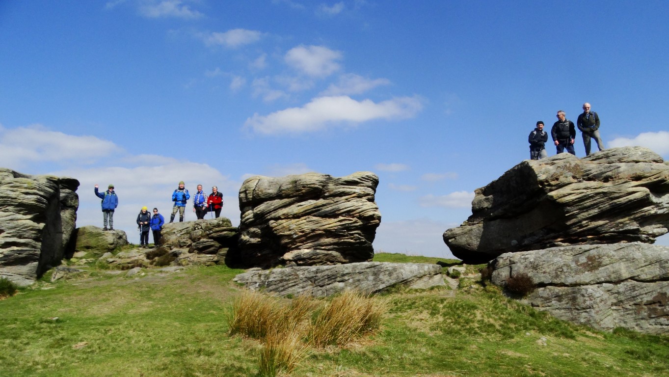
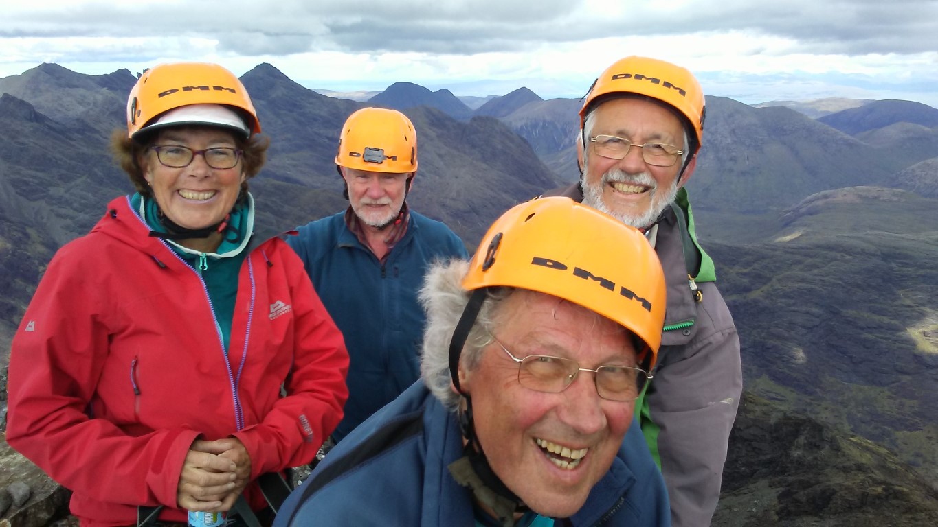
Meet the gang – mountaineers Monica, Nick, Rob and Colin

So what is the Black Cuillin? It might be only seven miles long but this formidable chain of jagged peaks on the Isle of Skye is like no other in the British Isles and contains eleven Munro summits. The rocky summits tower skywards above sheer rock faces and consist of a complicated mix of the volcanic rock known as gabbro intruded with basalt dykes and several other rarer rocks including the very metallic peridotite which play havoc with your compass bearing. Knocking two pieces of peridotite together gives very much a metallic chink. The gabbro is very coarse and gives a good grip but the basalt becomes slippery when wet so it is idea to distinguish what you are walking on.
So here we are, four members of the East Cheshire Ramblers about to embark on quite an adventure. Due to the nature of the Cuillin’s we have hired a guide not only lead us up and down through the maze of crags but also to lead us roped up through trickier areas and to oversee and help us down anything we need to abseil.
For myself, I had only been up one of the Munro’s on Skye and that was the outlier of Blaven many years ago but for all of us, this was a new area to us all.
It’s a Saturday in May and the fine weather of the past week is at an end. Gathering at The Sligachan Hotel which everyone calls ‘The Slig’ we meet our guide for the next four days Tom who works for West Coast Mountain Guides. Like every day, it’s going to be an early start.
The weather forecast which as we find out is not always that accurate suggests that today will be the worst day of the next four so we opt to do the easiest walk of the four days to ease our way in and get a feel to the area. With Tom on board, we travel in one car to the start and today’s walk will be to scale two Munro’s – Sgurr a’ Ghreadaidh 973 metres then Sgurr a’ Mhadaidh 918 metres.
Setting off from Glen Brittle Youth Hostel our rucksacks are filled of not the usual items. This time we have to stuff in a hard hat, and harness together with an array of carabiners. Out goes my heavy camera – I will have to make do with my phone camera and hence the quality of my photographs won’t be quite as good. I don’t even need a map. For myself, it feels a bit strange going into a mountainous area without a map but we have full confidence in Tom.
At a steady pace we trek uphill beside the Allt a’ Choire Ghreadaidh with Tom leading our little group and after a good hour and a half we are well up into Coire An Dorus. Ahead lies a narrowing stone shoot leading up to the narrow gully leading to the An Dorus Gap which will ultimately lead up to both Munro’s. After a brief break it’s time to put on our yellow hard hat and get kitted up with our harnesses. Tom produces a rope and links us all up to give us practice of walking with a rope as a group. The rope needs to be kept taut. For now the yellow hard hat will give us some protection from any loose rock from falling from above. As we gain height so the stone shoot narrows and we have some easy scrambling up over some bigger rock steps. The crest of the ridge comes very suddenly with a steep drop going down the far side over rocky crags towards Loch Coruisk. It’s here that we are going to leave our rucksacks to tackle Sgurr a’ Ghreadaidh.

Tom, our guide leads out on the ascent of our first Skye Munro – Sgurr a’ Ghreadaidh.

Nick, Rob, Monica or our guide Tom on our first Black Cuillin summit Sgurr a’ Ghreadaidh.

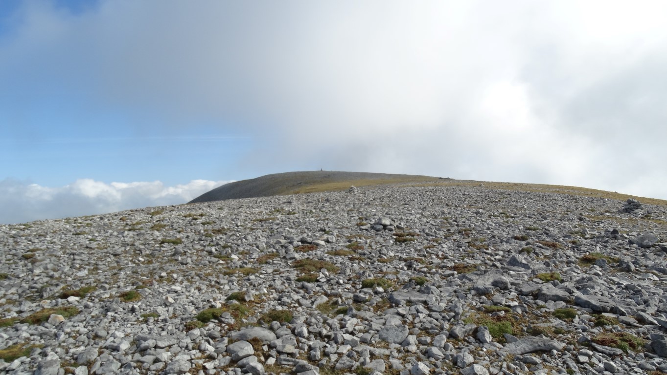
From An Dorus Gap there is a rock wall on either side. Tom leads out to belay some fifty feet about and shouts down for us to start climbing. Roped together means progress is slow. The key is remembering how Tom tackled this first bit and where do you put your feet. One by one we work our way up this first bit of somewhat awkward rock face. Beyond, the steep ascent continues but for much of the way is just a scramble except for a couple of awkward steps. It’s our first experience of being somewhere with a big drop below. A large rocky tower, known locally as ‘The Wart’ is skirted around on the western side to gain the tiny summit. It’s one summit down and ten to go. And yes we have got a view despite the grey overcast day.

The route taken up and down Sgurr a’ Ghreadaidh. Note the party making the ascent as we did a hour or so earlier.

Our route back is as our upward route except this will involve what is known as ‘down climbing’. With me roped up at the rear of the group on the way up it now my turn to lead and remember our upward route on the way down. It’s not as easy as you think as you are often climbing down semi blind feeling for good rock steps to ease your way down. It helps to lean out and to look down to get an idea where you are going. For everyone else you can guide them down, sometimes by catching hold of an ankle above you and guiding a foot onto a rock step. Meanwhile Tom at the top has secured the rope before climbing down himself.
Climbing out of the gap on the other side, this time with rucksacks also involves a short climb but we are soon on  ‘easier’ ground if you can call it easier where we stop for a short lunch break. Coming to lunch breaks – stops were always very short and time only to grab a sandwich and a quick drink before we are off again.
Sgurr a’ Mhadaidh, our second Munro of the day proves more of a straightforward ascent. We were no longer roped up which made progress is much quicker. Dumping our rucksacks once more we scrambled up among the crags and were soon on this second airy summit. Again we are fortunate enough to get good views. The promised rain is nowhere to be seen.
Retracing our steps we were soon reunited with our rucksacks and time for another quick snack. Tom now searches out a easier route down to the An Dorus Stone Shoot where we descend as per our outward route.
We reached Glen Brittle Youth Hostel by mid afternoon and Tom has been pleased at our progress.
It’s day two and after the first successful day on the Black Cuillin, the weather has taken a turn for the worst. The weather forecast suggests that it will improve as the day goes on and fingers crossed the low cloud will lift off the mountains. As usual it’s a early start and we meet up with Tom at ‘The Slig’. Putting off the infamous ‘In Pinn’ for a better day we opt to do the three northernmost Munro’s – Bruach na Frithe, 958 metres, Am Basteir 935 metres and Sgurr nan Gillean 965 metres.
From the word go, the weather doesn’t look good with steady fine rain and the mist and murk well down on the mountains. It’s a case of donning wet weather gear even when we start.
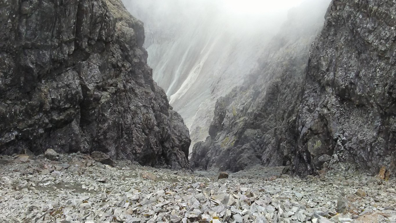
It’s a long walk in but it’s a good path to follow and it seems that we are the only ones setting out this morning. It’s such a pity that we have no views as the landscape ahead is quite spectacular with the pinnacle ridge of Sgurr nan Gillean towering ahead and to our left. As we gain height so that landscape gradually mists away. Reaching the western side of the Bhasteir Gorge we now need to clamber up to our right. There are several rock terraces and it’s very easy to take the wrong one. Tom scouts on to check that the route ahead the correct one. Once over this area we enter the hanging valley of Coire a Bhasteir but little can be seen. The whole place is choked withthick mist. Tom leads us up among scree slopes and crags towards the northern precipitous face of Am Basteir with a brief stop to put on hard hats. Conditions are certainly not improving and the fine rain at the foot of the mountain has turned to steady rain.
The decision is made to get to the top of Bruach na Frithe first which is the easiest of the three Munro’s planned for today. Dumping rucksacks, we toil up the steep scree slope below the overhanging northern face of Am Basteir and the cliffs are giving some shelter. The Bhasteir Tooth rises skyward into the mist but we do get an misty outline of this in the thick mist. Beyond, we round a craggy top before scrambling along to the summit of Bruach na Frithe. Crowned with a trig point it is the only summit with a trig point in this group of eleven Munro’s. It’s just unfortunate that the view is simply nil today.

The summit of Bruach na Frithe. The only summit in the Black Cuillin with a trig point but today there was simply no view.

We pick our way back along the ridge and down to our rucksacks for our lunch stop in the rain. The rocks are all running with water and in a discussion over lunch we opt to abandon any attempt on scaling anymore Munro’s today. It does mean now that we will not achieve our target of doing all eleven Munro’s on this trip but having said that, few groups are successful in completing all these Munro’s on one trip. The weather needs to be on your side and secondly the party needs to be very fit.
Disappointed we head back downhill crossing a stream that has swollen in the past three hours. We are all quite damp and glad to get back for a decent shower and freshen up. So we are half way through our course but only three Munro’s climbed.
It’s the penultimate day and despite not a very promising start weather wise we opt for the longest walk of the four days. It’s just three of us today plus our guide as Monica has been attracted to the bright lights of Portree. Again we collect Tom from ‘The Slig’ and travel down to the camp side above Glen Brittle Beach.
It’s a early start with three Munro’s ahead of us with Sgurr nan Eag 924 metres on the cards first, followed by Sgurr Dubh Mor 944 metres and a ascent of Sgurr Alasdair 993 metres to finish with.
It’s a long walk in over relatively easy ground and slowly ascending with increasingly good views out to sea to Rum, Eigg and Tiree with the Outer Hebrides on the far horizon. To the west it is quite sunny but showers are building up already with a few shafts of rain falling here and there. After a good two miles we start to head up into Coire Ghrunnda and the terrain soon becomes steep with a jumble of house size boulders to negotiate. Tom has a good balance and is able to walk from boulder to boulder with confidence but the rest of us take on this part a bit more caution. A further steep rocky ascent which requires a bit of knowhow on way finding climbs up to a second hanging corrie and Loch Coir a Ghrunnda. It’s time for a short morning break before skirting the loch and pressing up the scree and crag slope over increasingly difficult ground. Nearing the crest of the ridge it’s time to dump rucksacks before picking our way along the airy ridge to Sgurr nan Eag where we get a excellent view. The hill cloud of earlier is lifting off the tops. It’s now a case of returning to our rucksacks.

A easy scramble at the start of the ascent to Sgurr nan Eag.

With a quick bite to eat we are off again bound for Sgurr Dubh Mor and this section of the walk proves quite tricky. Although we do manage to bypass the rock stack called Caisteal a Garbh-choire. The route chosen is called the ‘Runners traverse’ which skirts along the eastern side of several crags and this proves a little used route and involved a fair bit of scrambling.

Setting out across the ‘Runners Traverse’ which cuts out climbing over some rock stacks.

The view back along the ‘Runners Traverse’

On the ridge west of Sgurr Dubh Mor the rucksacks are left again before making quite a difficult ascent to this summit which involves a few awkward moves and working your way up a chimney. This summit lies off the main Cuillin ridge and it proves time consuming to reach. Roped up, Rob leads us down towards our rucksacks but takes us out onto an airy ledge which we decide to call Rob’s Traverse – an airy little walk with a big drop but good hand holds. It is like standing on the window sill of a three story building!
Re-united with our rucksacks, it is time to bag the last summit of the day and the highest in the Cuillins. To get to the summit of Sgurr Alasdair meant skirting along the southern flank below sheer cliffs on a steep scree covered slope to gain the south western ridge via a ‘chimney’ not far from the summit. The chimney proves a hard climb and in places we have to use our feet on one side and our back on the other to work your way up. As usual Tom was always above with the rope secured. The last little bit is an airy scramble to the tiny summit with the ground falling away either side into the abyss.

The summit ridge of Sgurr Alasdair with a view towards Sgurr Thearlaich.

For a few minutes we were the highest people in the Hebrides. Now for the descent which means working our way along a narrow rocky ridge down to the top of the Great Stone Shoot where we stopped for a break. Hemmed in by the rock walls of Sgurr Alasdair on one side and Sgurr Thearlaich on the other, The Great Stone Shoot is the longest scree slope in Britain but the angular stones come in all shapes and sizes, with the stones at the bottom generally smaller. The descent is incredibly steep and once in motion it is difficult to stop. This is where our builder gloves come in handy as virtually no one descends this steep slope without sliding down on their backside.

So we are going down there are we? The top of the Great Stone Shoot.

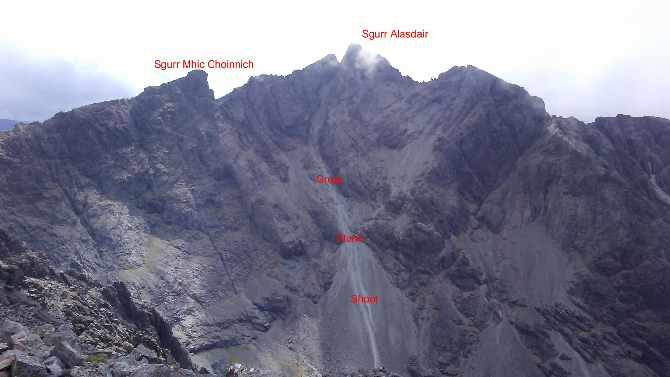
The view of the Great Stone Shoot taken on the following day. We descended this route from Sgurr Alasdair. At nearly 2000 feet it is the longest scree slope in Britain as is incredibly steep.

The foot of the Great Stone Shoot below Sgurr Alasdair.

Some of us were quicker than others and others (not in our party) spent more time on their rear coming down. The hard hats are essential and it was well advised to keep well apart from anyone else due to the amount of loose stone. Safely at the bottom we are reunited for the walk back to the car and a later than usual finish and our tally on the Cuillin Munro’s now totalled six.
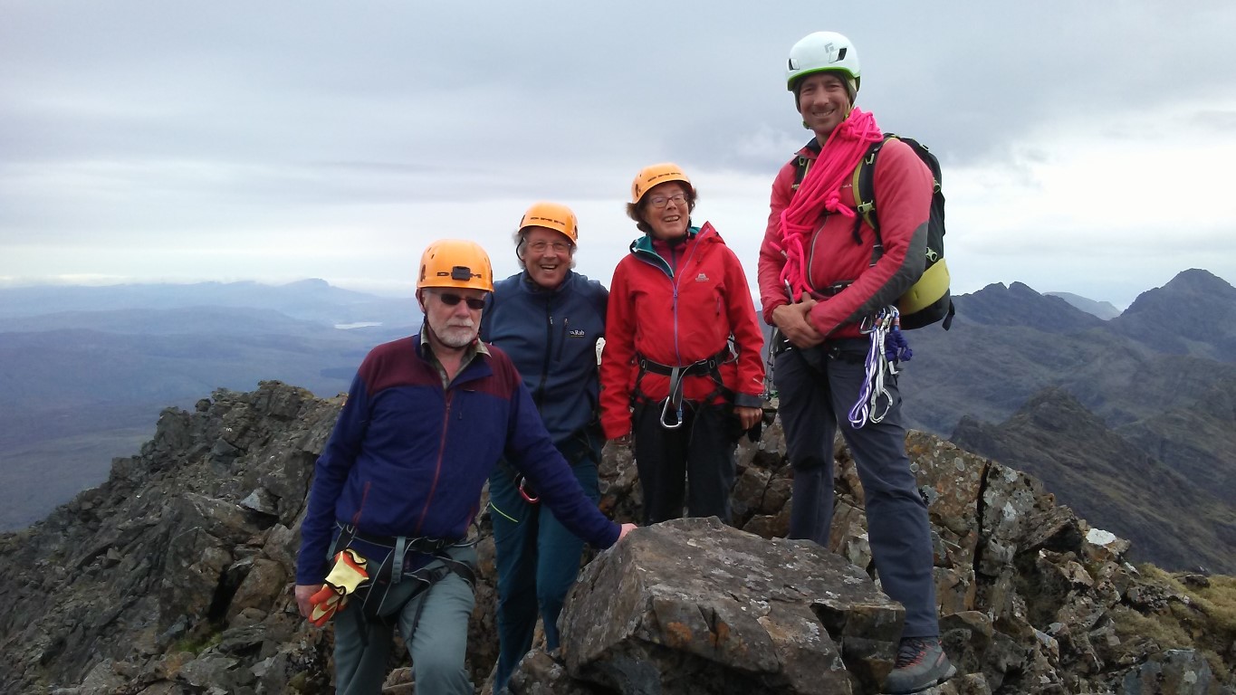
Monica has rejoined us for the last day and we are now faced with our greatest challenge. The ascent of the Inaccessible Pinnacle 986 metres and Sgurr Mhic Choinnich 948 metres rated as first and second hardest Munro’s to climb.
From the start we have ruled out climbing Sgurr na Banachdich, – a Munro but a much easier one which can be reached without a guide. The decision is taken to climb directly from the Glen Brittle Memorial Hut up the western ridge of Sgurr Dearg and going via this route we gain height quickly. The ascent is fairly straightforward with just a little easy scrambling among the crags higher up. Other groups have set out before us and so are expecting a queue to climb the In Pinn. At least today, the visibility is excellent and away from the mountainous areas it is quite sunny.
We reach the top of Sgurr Dearg before noon and made the down climb of steep sloping rock with loose scree to the base of the In Pinn. In the silence of the late morning some thousand feet below us comes the sound of crashing rock and as we find out later, several hundred tonnes of rock had come away from the mountain side and has scattered down the steep slope. The biggest pieces are the size of a bus so we were just glad we were not in that area at the time. With Monica and myself reaching the point where we have to make the climb of the In Pinn first, Tom decides to lead us first as there is no queue. Meanwhile Nick and Rob will have lunch and await for our return. The Matterhorn and most Alpine peaks were conquered before the In Pinn and it wasn’t until 1880 that the In Pinn was finally climbed by Charles and Lawrence Pilkington. They were guided to the foot of the climb from Sligachan via Coruisk and Bealach Coire na Banachdich by a local shepherd called John Mackenzie.

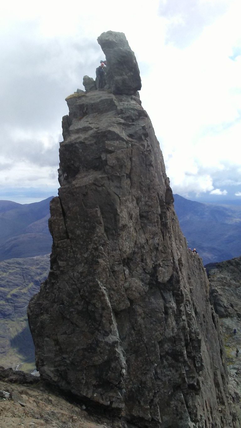
Our first view of the ‘In Pinn’. Note the climber on top. We will abseil off this side later. We will ascend via the ‘easier’ far side.

The side we ascended The ‘In Pinn’. monica can be seen in the stone shelter, bottom left. the ascent is very exposed on either side so best not attempted in wet and or windy weather.

Nick followed by Rob on the first pitch of the ‘In Pinn’. The guide only takes two of us up at any one time. Tom our guide is out of sight just over the pinnacle.

The view on top of the ‘In Pinn’ looking southeast. Being roped up and constantly on the move there are few precious moments to get photographs.

Tom sets off up the knife edge ridge to secure the rope for the first pitch and we watch carefully where Tom is placing his feet. Monica and I are attached on the rope at the bottom with Monica taking the lead. I follow on behind at the end of the rope. The first thirty feet is fairly straightforward but then you have to get onto the knife edge ridge with hand and footholds quite smooth over time. Re-united briefly with Tom he then climbs the second pitch whilst Monica and I cling on the narrow ledge above the abyss. Tom shouts down to start climbing. It is getting airy with an overhanging and infinite drop on one side, and a drop on the other side even steeper and longer. Now concentrating on what I am doing and planning each step is paramount. Now I know that climbing shoes are better than walking boots in this type of terrain. The footholds are so small that below the soles of my boots are hundreds of feet of air! I cling on trusting that my hands will hold as the knife edge steepens and daring not to look down. Thankfully the ridge eases but at the same time gets much narrower as we make our way to the airy summit with much relief.
It is now time to abseil down the steep side, an eighteen metre sheer rock face. Tom is going to do a stacked abseil meaning we would all go down the same rope. The massive rock on the summit has a fixed chain around it with carabiners which you can attach the rope. Now I am thankful that I had abseiled before and I am more confident for the descent. Tom descends first with me following and remembering what I had learnt on Tegg’s Nose a few weeks earlier. Lean well back, feet apart and let the rope feed through your hands as you walk backward down the rock face. It is all over in a moment with feet firmly on terra firma. Monica follows confidently and at speed and the three of us make our way back to Nick and Rob.
It is now their turn and again Tom leads on up the rock face before Nick and Rob start out on their ascent. Meanwhile Monica and I settle down to lunch in the shelter of a dry stone wall but it seems a long time before the three of them return and we are beginning to get cold.
We are glad to set off and made our way slowly down to the col above An Stac screes. On the way we pass the massive rock fall from a couple of hours earlier which lay right on our path and it seems that more rock is ready to fall, hence we don’t hang about here.

Dumping rucksacks we will now attempt the climb of Sgurr Mhic Choinnich which is said to be the second hardest Munro in the Black Cuillin. there are certainly some very airy drops as you work your way along the ridge.

On the summit of Sgurr a’ Ghreadaidh with the view towards Sgurr Thearlaich and Sgurr Alasdair. note the climber at the summit.

The summit ridge of Sgurr Mhic Choinnich. The easiest route is to stay right on the crest.

Near the col we pause awhile and leave the rucksacks weighted down with a few rocks before making the ascent on the complicated Sgurr Mhic Choinnich. The summit is said to be the second hardest Munro to climb in the country and route finding proves not easy. For much of the way we are roped together and Tom opts to keep us right on the crest which in places has an almost sheer drop of several hundred feet on the western side. The summit is narrow with smooth steep slopes on either side almost as if you were on the apex of a rouse with steeply sloping roofs.

The red arrows show the route taken from Sgurr Dearg and The In Pinn to the top of the An Stac screes. there had been a rock fall of several hundred tonnes a couple of hours prior to this photograph being taken.

For the return, I lead the way, picking my way along the crest and all the time we are roped up. I find a ‘chimney’ which seems an easier route and once in it we are committed until we can gain the ridge again. Back with our rucksacks after what seems to be quite a long time we take a break before descending the An Stac screes which although much shorter than the Great Stone Shoot we still end up with us well spaced out. The walk out was from Loch Coire Lagan is noted for its smooth rock gouged out by glaciers.

Smooth rock gouged out by glaciers make these features look a bit out of place. This rock looked like a stranded whale. This photograph was taken in Coire Lagan on our last day in the Black Cuillins. The Cioch is shown up by the shadow it is casting on the rock face.

High to our left we spot two climbers high up on the rock face called The Cioch. This is a massive piece of rock which almost defies gravity and sticks out of the rock face. In 1986 it featured as the setting for a sword-fight in the movie ‘Highlander’. Our pace now quickens as we gain easier ground and in afternoon sunshine make our way back to the Glen Brittle Memorial Hut.
Overall we had bagged eight of the eleven Munro’s we had set out to do and the weather has been kind to us on three of the four days. I understand that you could go to the Cuillins and bag no Munro’s if the weather was bad and so overall we haven’t done too bad. Having said that, we are all very grateful to our guide, Tom Sylvester which without him, this adventure would not have been possible.

Group walk report 10th April

All assembled at Birchen Edge Trig point.

With the promise of a reasonable day it was somewhat of a shock as arriving at Curbar Gap Car Park we were greeted by a biting and raw easterly wind.

We set out by heading north on what was to be a walk along ‘five edges’ and first of all we followed Curbar Edge for nearly a mile before descending and doubling back below the cliff face. At Warren Lodge we took the lane downhill for a short distance then took paths around the southern side of Curbar village passing on the way the converted ‘lock-up’ which dates from 1780 and was used as a local gaol.

After stopping for a morning break we continued via Gorsebank Lane to reach Baslow where we took a path down to cross the busy A619 close to the Cavendish Hotel. We were soon in Chatsworth Park entering via the unusual Cannon Kissing Gate. We ascended across the park entering woodlands at Dobb Edge. At the top we turned sharp left to follow the concessionary path along the ridge and later at a sheltered spot behind a high wall we stopped for our lunch out of the wind.

For the afternoon leg of the walk in which the sun made more of an appearance, we continued on the concessionary path to the A619 and crossed to the Robin Hood Public House before making our way up onto Birchen Edge. We paused briefly by the ‘Three Ships’ – three rock outcrops where the names of ships that Horatio Nelson served on are engraved into the rock face. The three names are Soverin, Defiance and Victory. Nearby is Nelson’s Monument which was originally erected in 1810 by John Brightman, a Baslow man. Reaching the trig point we took a un-defined path to the less known Gardom’s Edge. From here we headed northeast to reach the crossroads of the A621 and Clodhall Lane.

Heading west next we made for the Wellington Monument which was erected by a local man called Doctor Wrench who felt the need to counterbalance the memorial dedicated to Admiral Nelson on nearby Birchen Edge. Heading back towards the cars we took the path north soon passing the gritstone outcrop known as Eagle Stone rather than follow the edge itself. This lone boulder is quite a landmark and historically, an ascent of the stone was a rite of passage for the young men of Baslow who were suppose to climb the stone before proposing marriage to a local maiden. The day finished with a visit to the tea room at the Derbyshire Craft Centre.

‘I see no ships’. Graham conquers one of the Three Ships on Birchen Edge.


‘The crew’ at The three Ships Birchen Edge.


The Eagle Stone on Baslow Edge. a lone monolith and landmark in the area.

Group walk report 2nd April

The group above Kinder Reservoir.

By Sue Thersby

A recent East Cheshire Rambler’s circular walk started from Hayfield in Derbyshire. There were eleven of us, in spite of the rain. The first written record of Hayfield is to be found in the Doomsday Book when it was called ‘Hedfeld’ and was a natural clearing in the vast forest at the foot of the Kinder Scout, the highest point in the Peak District (2088ft) and the southernmost point of the Pennine Chain. It became a mill village from the 17th century onwards and is famous as the birth place and childhood home of Arthur Lowe (Captain Mainwaring in Classic ‘Dad’s Army’) whose home is marked by a blue plaque, which we passed on our way towards Kinder Reservoir.
We climbed up the cobbled path to the west of the reservoir before turning westwards to arrive at the shooting cabin, where we had our morning break. After crossing Middle Moor, our route took us northwards, parallel to the Glossop Road before we crossed it, just before the now closed Grouse Inn. We then passed through a couple of farms before joining the Pennine Bridleway for a short distance. Continuing our way past Higher Plainsteads and Rocks Farms, we climbed gradually up to Cown Edge, from where we had 360-degree views over the surrounding countryside with Glossop to the east and Charlesworth to the north. We walked along the whole of the ridge in a generally southerly direction until we descended to Rowarth, a small village, which is locally famous for the Little Mill Inn, a pub and restaurant in a former candlewick mill, with a waterwheel in the adjacent stream. The Little Mill has a retired Brighton Belle Pullman railway coach which is used as guest accommodation.
Changing our orientation to south-easterly we passed Laneside Farm before climbing up a bridleway which eventually took us to the Pennine Bridleway again and Lantern Pike. Here our party split up and the more energetic climbed up the Pike, which boasts an orientation table and has magnificent views, whilst the others contoured round it. Finally, we gradually descended back into Hayfield via Upper Cliffe Farm. We were lucky enough to find the local chocolatier open at the end of the walk for our usual refreshments.

Group walk report 30th March

In Lathkill Dale

By Roger Jubb

The small former lead mining settlement of Over Haddon was the starting point for an East Cheshire Ramblers walk. On a fine spring morning the group descended to Lathkill Dale passing St Anne’s Church and tea gardens.
In the valley we crossed the river and ascended steeply the other side to Meadow Place Grange Farm. After a brief rest our ascent continued later crossing Back Lane to reach Moor Lane. The morning break was taken at the Moor lane Car Park.
Joining the trail called the Limestone Way we now headed west across fields to reach Low Moor Wood to reach the farm buildings at Calling Low. The Limestone Way is a 46 mile long way marked path running between Castleton in Derbyshire and Rocester in Staffordshire. A little beyond we crossed Cales Dale, a deep wooded secluded valley to reach One Ash Grange farm where there were several newly born lambs.
A little beyond the farm, a field path was taken on the right and a pleasant lunch stop was found overlooking the upper reaches of Lathkill Dale.
The return walk was through Lathkill Date to Over Haddon passing on the way a cave issuing crystal clear water. The sunshine had stayed with us all day and we rounded off the afternoon with a well earned rest at the Old Smithy Tearoom in Monyash.

Descending through Cales Dale.

Sheep with new born lambs at One Ash Grange Farm.

Crystal clear water from a cave in Lathkill Dale.

Rounding off the walk with afternoon tea at The Old Smithy Tearoom at Monyash.

Group walk report 6th April

A narrow section of the riverside path close to the hermit cave at Anchor Church.

The East Cheshire Ramblers recently ventured to a new area for the group on a recent walk from Repton near Derby. The walk had a historical theme and started out with a visit to the historic St Wystan’s Church. The church has a fine Saxon Crypt which was built in the 8th century as a mausoleum for the Mercian royal family and the burial place of three Mercian kings. Repton is well known for its private school which dominates the village.

Heading east the village we set out by taking a good field path over Askew Hill and later along another path to Anchor Church which is the name given to a series of caves in a Keuper Sandstone outcrop. The caves were once home to an Anchorite hermit St Hardulph who lived here in the 6th or 7th century.

Graham tests the water supply at one of the unique ‘Ticknall Taps’.

Continuing via Ingleby we next headed towards Ticknall on field paths. En route we paused briefly at Knowle Hill, site of a former Italian landscape garden, developed in the early seventeen hundreds which later became a pleasure garden in the 19th century before it was semi abandoned.

At Ticknall we came across the first of several ‘Ticknall Taps’ which are identical cast iron water pumps installed around 1914 by Sir Harper Crewe to, what was then, the estate village to nearby Calke Abbey which provided fresh water.

In the grounds of the village hall we stopped for lunch by which time the sun was breaking through. We explored the village afterwards including stopping at the old lock up and visiting Sheffield House, an imposing three-storey house with the top floor being false. It was built in the 1840s by George Sheffield, who was a doctor, and William Sheffield, who was a veterinary surgeon. They emphasized the size and independent status of their property by adding a false third storey that carries the name ‘Sheffield’ prominently on its parapet.

A clever disguise. Sheffield House in the village of Ticknall has a false third floor.

Finally it was a visit to the churchyard to view the parish church and the remains of the medieval church. When the new church was built by the Victorians, they opted to blow up the old church leaving just the few ruins we see today. The return to Repton was initially along part of the National Forest Way and crossed numerous fields. The day was rounded off with a visit to Mrs Bee’s Tearooms in the nearby village of Findern.

The parish church at Ticknall. So what do you do when the medieval church becomes redundant. In this case, the Victorian’s simply blew it up leaving these remains in the churchyard.

Group walk report 3rd April

The ramblers are dwarfed in the chasm at Lud’s Church.

By Ken Hobbs

The sun was breaking through dark clouds as a group of seven walkers, led by Ken Hobbs, set off from Gradbach Car Park on a chilly April morning. We passed by the former Youth Hostel at Gradbach Mill, before crossing Black Brook and walking briefly alongside the Dane, before climbing through Gradbach Woods.
After rounding Castle Rocks, we scrambled through the natural chasm known as Lud’s Church. This was supposedly used by the Lollards, followers of John Wycliffe, for worship in the early 15th century. Another legend is that it is the “Green Chapel” referred to in the medieval poem “Sir Gawain and the Green Knight”.
Eventually we reached the ridge and turned south towards the fantastic rock shapes on the Roaches, at this point made eerie by swirling cloud. The cloud had dispersed by the time we had finished our coffee break, and after we passed the trig point at 505 metres we enjoyed clear views towards Hen Cloud, Tittesworth Reservoir and Leek in the distance. The eastern flank of the Roaches is still scarred by the wildfires from last summer, but there were signs of recovery. A group of schoolchildren sat at the side of the Doxey Pool, undeterred by the story of a mermaid siren that is said to live there! Finally we visited the stone plaque erected to commemorate the visit of the Prince and Princess Teck (the great grandparents of Elizabeth II) in 1872.
After descending the Roaches, we worked our way around the back of the rock formation of Hen Cloud, but there was no sign yet of the peregrine falcons that normally nest here. Our way back was along footpaths running parallel to the Roaches, through a number of fields, interesting stiles and farms with evocative names such as “Windygates”, “Pheasant’s Clough” and “Buxton Brow”, enliven by the sighting of a hare and a shower of hail!
At last we climbed back to cross the ridge at Roach End and descended back through Gradbach Woods to Black Brook, where often Dippers can be seen, but not today. Finally we passed through the Scout Camp and returned to the car park, tired but reflecting on an enjoyable nine mile ramble.

Scrambling out of the chasm as Lud’s Church.