

Slipping out of Kirkwall Harbour early in the morning en route to the Island of Eday.
Poring over maps as I so often do, I conjure up a ‘3 D’ picture in my mind of a certain area and one such area had long been the northern tip of the island of Eday in the Orkney Islands. A prow of land shaped like the bow of a ship culminating at the trig point at Red Head. I have long been intrigued by this location and promise myself that it was high on my visit list.
Eday is just ten square miles and has a population of around 130 inhabitants and is the ninth largest island in the Orkney archipelago. The island lies around fifteen miles north of the Orkney capital Kirkwall.

A distant view towards Red Head at the northern tip of Eday.
Planning a day trip to Eday with my son Stewart back in 2013 during a week long trip to the Orkney Islands meant we were restricted to Wednesday due to the ferry timetable and so I was banking on good weather. My initial plan was not to take the car to the island but with the weather being somewhat doubtful and the island having little if any shelter, it was worth spending the extra few pounds to make a day of it and if needed have the shelter of a car if the weather took a turn for the worse.
The ferry meant an early start as we had to be in Kirkwall by 06.30am for the rather long trip via the island of Stronsay. It was after 9am by the time we were disembarking on Eday and then in a rain squall. We drove north up the island spine road, the empty B9063. This was an area that even Google street level mapping hadn’t reached! Our main aim was to get a good walk in but parking proved a problem as most lane endings finished at a farm entrance. In the end we found a small car park at the bird hide by Mill Loch. It was time for our morning break as another rain squall moved through but the weather looked good after that. The Ranger for the island turned up and we chatted awhile. She was surprised to see ‘tourists’ as she estimated that we were about the eighth tourist this year.
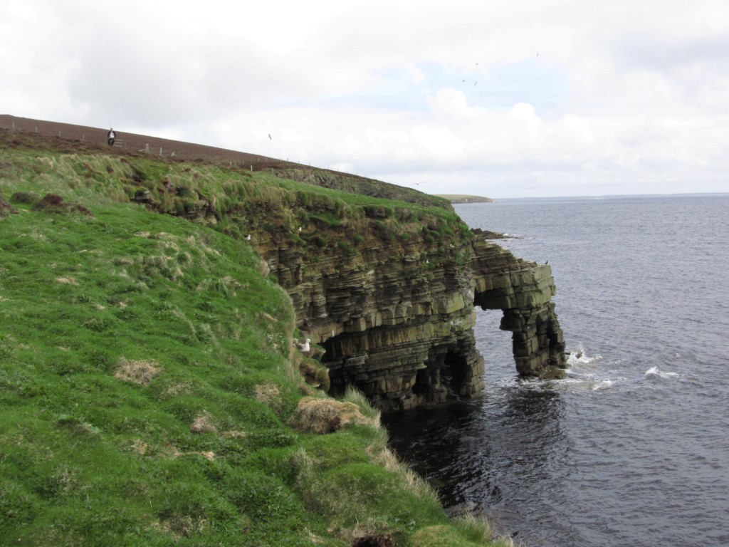
Stephens Gate, a natural arch on the eastern side of Eday was passed early in our walk.
Stewart and I set off on our walk along the lane towards the hamlet of Hammerhill to visit the island shop. I am always interested to see how well stocked these places are and the variety of goods on the shelves. As well as the range of foods these shops are like mini department stores. It was now for some serious walking as we took the track behind the hamlet towards the coast. The track degenerated into a path which later disappeared altogether but at least wooden marker post kept us on the correct route. Turning north we followed the coast passing Stephens Gate, a natural arch on the low cliffs. Further on we passed a couple of sea stacks called The Castles where a stout barbwire fence separated us from the cliff edge and so views were limited. We had to turn away from the coast here before a right turn along a grassy track to the deserted B9063. A left and right turn took us along another lane via Carrick Farm to the historic Carrick House. This was the location where John Gow, the notorious Orkney Pirate luck ran out. His life started as a deck hand on one of the many ships which plied out of Stromness but on one trip, and with bad feelings running high, he and others mutinied and killed the captain and other senior officers before renaming the ship ‘Revenge’ and carrying out piracy on the high seas and so Orkney has its own ‘Mutiny on the Bounty’ story. John Gow took his pickings by raiding prosperous houses on the coast but came unstuck when he chose to take the rich pickings form Carrick House in 1725. His ship ran aground and he was overpowered by staff and islanders. His fate was that he was tried in London for his crimes and along with other accomplishes was hanged. Today Carrick House overlooks Calf Sound in much more peaceful times.

Carrick House overlooks Calf Sound and the location where the notorious pirate John Gow’s luck finally ran out.

The Calf Sound Lighthouse towards the northern end of Eday set on the edge of a aquamarine sea.
Heading north, Stewart and I now followed the shore with a brief stop at the Calf of Eday Lighthouse. The path ahead petered out and so we made our way uphill to follow a better path along the ridge to the trig point at Red Head. Despite its modest 70 metres above sea level, the headland afforded far views to the islands of Westray, Sanday and North Ronaldsay set in a aquamarine sea. Thankfully we had picked a perfect day and we were being blessed with sunshine. The headland as such was surrounded with a new and stout barb wire fence and not easy to cross, but I ventured out to the headland not that you could see much of the sandstone cliffs.

Red Head at the northern end of Eday. It may be only 70 metres above sea level but the views on this day were magnificent.
Setting off once more we followed the coast south westwards before turning towards Vinquoy Hill by which time it was turning into a really fine sunny afternoon. As we followed the hillside along to the summit of Vinquoy Hill the views across Calf Sound were spectacular and we could hardly believe our luck to get such good weather. Along the ridge of Vinquoy Hill we came to Vinquoy Chambered Cairn. We could crawl inside to the main chamber of this perfectly preserved chambered cairn. A short walk took us downhill across one or two areas of boggier ground but thankfully with board walks to reach the Stone of Setter, Orkney’s tallest standing stone at 4.5 metres. Finally it was back along the road to the car then to spend the rest of the day exploring the rest of the island including a shorter walk around War Ness at the southern end of the island and up to Ward Hill, which at a modest 101 metres is the highest point on the island.

Vinquoy Hill Chambered Cairn which you can crawl into.

The Setter Stone which at 4.5 metres tall is the highest standing stone on the Orkney Islands.
Heading back down the spine of the island there was another place worthy of a visit. The tiny airport on the island is just so located at a spot called the Bay of London and hence is named London Airport. So imagine this London Airport with free parking, absolutely deserted, and no aircraft.

I managed to get to the ‘airside’ without being spotted by security. This is the other London Airport.

A wooden direction indicator on Ward Hill near the southern end of Eday.
Returning to the ferry terminal it had been a great day out to a place in the British Isles where few venture.