

The Breamish Valley west of Ingram. Twenty minutes earlier it was raining and the place looked so different.
I want to walk in the hills in the Northumberland National Park and a chance to bag some of those outlying summits close to The Cheviot or so that’s the plan.
It’s September and with several wet Sunday’s in a row, surely it was time to have a decent Sabbath. I’m staying in Berwick upon Tweed and the weather is dawning fine and sunny and so with a forecast of possible showers later in the day I set off south to drive via quiet B-roads and through a sunny Wooler to head to the Breamish Valley. As I near the Cheviots I begin to have some doubts as my plan is to walk over the remote moors to Bloodybush Edge then bag Cushat Law and Shill Moor on the way back. Driving up through the Breamish Valley there is a rainbow ahead of me and the sunny skies of earlier is quickly filling in. I’m expecting to see many cars at the limited parking at Hartside but on my arrival there was no one there. It is blowing a gale and the hills around Cushat Law are now draped in hill cloud and shafts of rain are sweeping across the hillside. The prospects don’t look that good so it is time for a rethink. Walking in these conditions will not be fun, and here I am with yet another hill walk not coming to fruition. At least back at Ingram the weather is fine and that is only a few miles further east. Perhaps I could do a walk from there I think.
Returning to Ingram the car park is now full with a large rambling group assembled and so I have to cross the road bridge and park on common land on the far side.
My plan now is to head generally southwest and see how the day progresses. It is unusual for me not to plan a route in advance. The sunny weather has returned, even on the higher hills and for awhile I think that a day on the higher summits has been missed. On the other hand it is blowing a gale and this interval of fine weather isn’t to last.

Walking at its best. A easy open track climbs into the hills at Turf Knowe west of Ingram.

My route ahead towards the isolated house at Chesters, seen almost in the centre of the photograph. For awhile the weather looks good. My original plan was to walk in the hills on the horizon.
Under sunny skies I’m setting off west from the village of Ingram and soon take a good hill track southwest climbing gradually to higher ground and according to my map passing several areas of medieval Cultivation Terraces although these are mostly lost in the bracken. My plan is to follow the bridleway over to the isolated house at Chesters and for the first part, the track is well defined. Further west as I descend towards Chesters Burn so the path becomes overgrown with bracken and not only that, it appears to veer off further north to what is shown on my map. At first I can’t see any way through the forestry block ahead of me but I eventually find an old wooden gate. At least here is a sheltered spot for my morning break before venturing through the forest. It is by luck that I pick up a path that runs all the way through the forest and despite this being a bridleway, it would have been hard to get a horse through here. The western edge of the forest has a much clearer gate and I now head uphill across open pasture towards Chesters and here the path is not that well defined. Chesters is a large house in good repair but certainly has not been lived in for some time. Beyond, I pick up a good track but now the weather looks to be on the change. There is little shelter in this area and on reaching the crest of the windy ridge I opt to divert to a woodland block to my right to have an early lunch. Climbing a fence I enter the edge of the forest. It gives some shelter as I tuck into my lunch and meanwhile the rain mostly passes to the south of me.

Hart Law (341 metres), the first of two trig points visited on my walk but the weather is beginning to close in.
Back out on the open moorland, a good track runs south and I opt to bag the first of two trig points of my walk. Leaving the track, I divert east over easy grassy ground to reach Hart Law 341 metres. It is blowing a gale on top and more rain is on the way. To the south, the Simonside Hills are already into the cloud base as shafts of rain are sweeping across the area. At least now I will be heading to lower ground but for the time being, I am walking into a headwind. Back on the track, the walking is easy and later I veer off to follow the right of way down passing Pennylaws South Plantation. I had expected this to be easy, but the enclosed path is quite overgrown and squelchy. At the foot stands an old tower house and traces of the medieval village of Alnham. The adjacent church is barricaded off and closed for restoration work but I manage to get into the churchyard for a closer look. St Michael’s Church dates from around 1200AD and stands on the site of a Roman Camp. The adjacent Tower House is very much obscured by trees and dates from around 1405 with a 19th century house attached. It was formally a youth hostel and has also been used as a vicarage.

The ancient medieval church at Alnham and with the weather set to turn wet, its time to get my waterproof gear on.
With showery rain very much around, it is time to put on full waterproof gear although for now the rain isn’t amounting to much. Setting off, I take a bridleway crossing fields over to the small settlement at Hazeltonrigg. It seems that I am the only person out walking today and there is very little life at any of the farms I pass. A short steep descent leads down to the valley through which flows Scrainwood Burn and here I turn left down to reach a lane. En route, I stop to investigate a new sturdy wooden shelter with seats which would have been an excellent place to stop for lunch if I had known. I can only imagine that it is some sort of shooting shelter.
From the hill country, I enter level farmland after passing through the large farm complex at Scrainwood. The wet weather is now sweeping in from the southwest making it a miserable afternoon. I briefly take shelter behind a tall haystack but this weather is moving through so quickly that rain one minute is often replaced by strong sunshine the next.
A left turn takes me onto the homeward leg and here it is easier to follow the field boundaries despite my map showing paths crossing open fields. With a sunny slot in the weather, it is a good opportunity to bag the trig point on Blackchester Hill (214 metres) which is not on a right of way. Passing through a gate, I follow the field boundary on the south side of a well built wall but at the same time keeping an eye on increasingly restless cows and calves to the south of me. I cross a gate at the far end of the field then through another gate to gain the trig point which stands on the edge of a shallow quarry which has been partly in filled with farm rubbish.
With more rain on the way and with the cows and calves up against the route I had just taken, I opt to walk along the edge of the field to the north of the wall which means crossing an electric fence at the end. A right turn at the end takes me down to Alnham and now the driving rain sets in for a short while. I am just glad now that I wasn’t on those higher hills.

A lovely vivid rainbow as I leave the tiny village of Alnham. The sun has come out but it’s still raining hard.

I’m at the hill fort to the northeast of Cochrane Pike and another shower is closing in.
At Alnham, I join the lane towards Prendwick and I am soon rewarded by a most vivid rainbow. Despite the rain still lashing down, I manage a few decent photographs. For now, the sunshine returns as I make my way along quiet lanes to Prendwick and at the end of the hamlet I join a hill track towards Ingram. This is proving a lovely walk and at a gate I opt to remove my waterproofs as it looks as if the showers might be over for the day but I am wrong. In the meantime it is a delightful walk over the shoulder of Cochrane Pike but those ominous shower clouds are again making an appearance. I divert from the track briefly to look at an ancient hilltop settlement northeast of Cochrane Pike and now to the west it looks as if the heavens have opened. I am so glad that I decided not to venture up to Bloodybush Edge and Cushat Law. The end of my walk isn’t far off and with the storm clouds becoming ever closer I follow a most pleasant track down to Ingram. On the way I stop to photograph a rainbow and the heavy shower which is passing just to the north of me. Reaching Ingram, I am in good time before the tea room closes and treat myself to a locally made ice cream. The place is full of ramblers who I find out is a re-union of the Newcastle YHA Group. I sit inside to have my ice cream as the heavens open briefly which means that I have timed it well.

Homeward bound. It’s time like this when walking is most rewarding. – A good track, a rainbow, bright sunshine and I’m not getting wet.
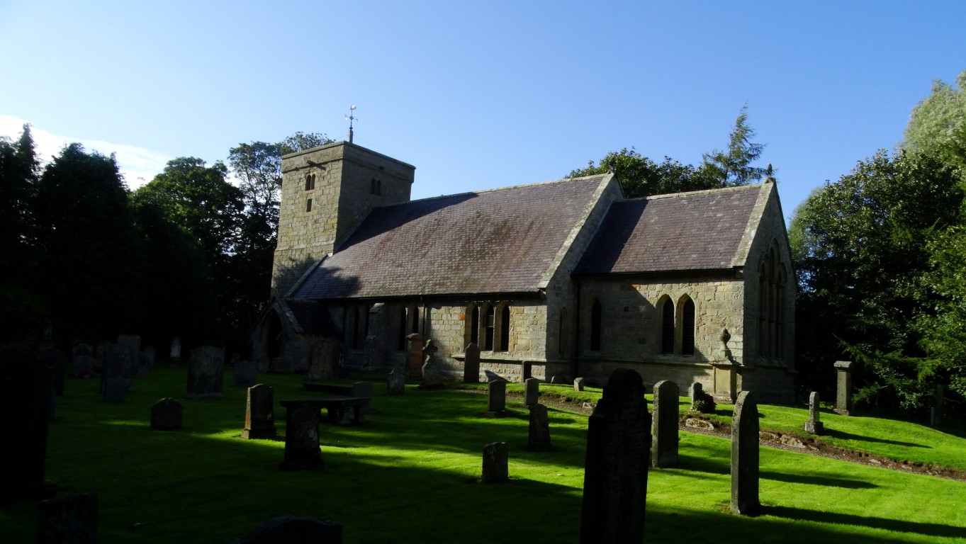
Shadows begin to lengthen at St Michael all Angels Church at Ingram almost at the end of my walk during a visit between two downpours.
Afterwards and back in bright sunshine I briefly take a look at Ingram Church before walking the short distance back to the car and changing out of walking boots moments before it pours with rain again. On my drive back to Berwick I am rewarded by yet another vivid rainbow.
Despite not venturing into the remotest part of the Cheviots I have had an excellent day’s walk skirting around the foothills and dodging the showers. It’s been one of those days that was good to be out in the elements and rewarded by some very contrasting weather.