

One of several information boards along the Tas Valley Way. This one is at Old Buckenham.
I have walked most of the trails in East Anglia and for several years I have headed to that part of the country in the autumn as it is one of the areas of England that hangs on longest to the fine weather. It’s a time of year when the crops have been harvested and the fields are bare or have just been sown and generally the countryside is beginning to close down for the winter. The first signs of autumn are all around.
Walking in this part of the world may be flat but I love the wide open skies, the birdsong, and the attractive villages most of which have a medieval church to visit although more and more of these are now locked due to vandalism. So this year I opted to walk the Tas Valley Way. It’s a relatively unknown trail and winds its way across the Norfolk countryside between Attlebrough and Cringleford , the latter being located on the southern outskirts of Norwich. The trail will take me two days to walk and using the Travelodge at Cringleford as a base the first days walk will involve three bus journeys.
When planning these trips several months in advance I scroll through countless bus timetables on the internet to see if the walk is feasible by using buses. That done, I recheck to see if there are any timetable changes a few days before I set off on my adventure.
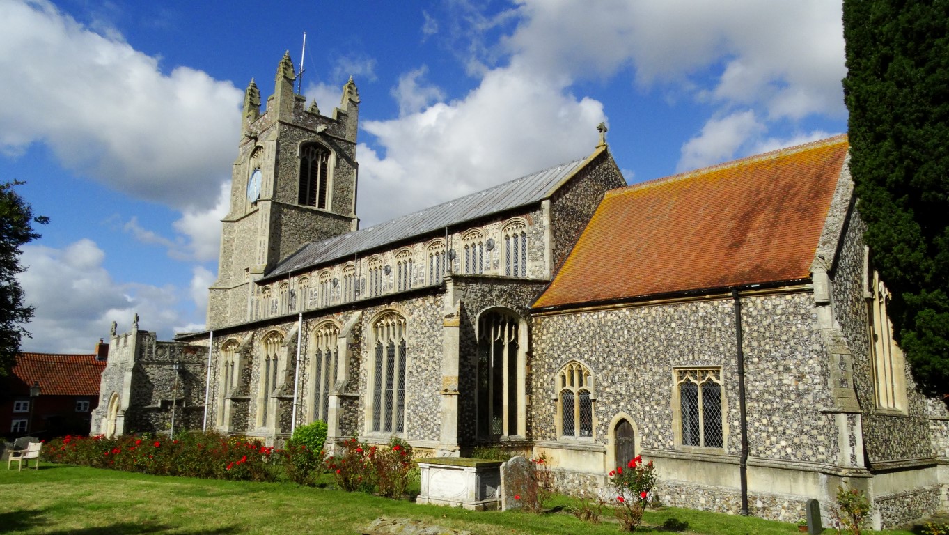
Luckily for me I can conveniently catch the school bus right to start of my walk. It’s the one and only bus where I can make the outward journey without a bus change in the town of Wymondham. It’s a early start to catch the 07.31am number 13 bus which is already packed with school children who almost all alight at Wymondham College. I’m leaving the bus at small town of Attleborough and decide first on a wander around the town centre before setting off this 17 mile long first leg of my walk. Despite a bypass, the town is choked with rush hour traffic as I make my way to the parish church of St Mary’s which is noted for its medieval wall paintings. There has been a church on this site since Saxon times but much of the building today dates from the 14th century.

St Mary’s Church, Attleborough noted for it’s fine wall paintings.

In Attleborough Town Centre by the attractive town sign, a feature of many towns and villages in East Anglia.
I set out southwest on the rather busy Hargham Road despite this being an unclassified road. The early morning showers that had scuttled in off the North Sea overnight are quickly disappearing to reveal a fine clear sunny autumn morning and just the weather for walking despite a cold breeze. I pace the first two miles out of Attleborough and leave the Hargham Road and join a minor lane south which soon crosses the main railway line. So far I have not found any way-markers to indicate that I am on the Tas Valley Way.
I later turn left on a good track. The overnight showers haven’t really ventured this far west and so walking is dry underfoot. I continue on minor lanes through the ribbon settlement of Fen Street to reach the attractive village of Old Buckenham. The village is set around the large Church Green. I make for the church of All Saint’s, an attractive old building with an octagonal tower and thatched nave. The building dates from around the 14th century but parts are from an earlier date. A sunny seat in the churchyard is an ideal spot for my morning break. It’s so peaceful with crows calling in the trees and the sun still giving a bit of warmth in this sheltered location.

All Saint’s Church Old Buckenham. The churchyard was an idyllic spot for my morning break.

A typical field path between Old and New Buckenham. Wide open skies give fine views and field boundaries are often just a ditch.
A good field path leads east to Old Hall and after this a path diversion takes me along a field boundary rather than crossing a large ploughed field. The next village is New Buckenham and entering the village I divert on a field path to take a look at what is left of the castle. I discover that the site is private and the key is available from a house in the village. From what I could see I decide that it isn’t worth the effort. There is little left of the castle and the keep stands only a few metres high. Far more dominant is the circular water filled moat and tree covered embankment. I head for the village church of St Martin’s and take a look inside. The church is quite a substantial building which reflects the wealth in this area.The village is unusual in this part of the world as the streets are laid out in a grid pattern. Looking around the village there are many historic buildings including the timber framed Market House which dates from the 16th century.
St Martin’s church at New Buckenham reflects the wealth and importance of a village in medieval times.

Interior of St Martin’s Church, New Buckenham.

The Market House in New Buckenham dates from the 16th century and is just one of several historic buildings in the village.
The blue skies of earlier are quickly filling in as I head east and furthermore, the path is now less well defined. At one point I take a wrong turn and have to back track across a very rough field before reaching Fir Covert Road. After a little road walking I set off again eastwards on an ill defined path that runs across ploughed fields to reach Shrubbery Farm. Beyond, I continue following field boundaries which are merely deep ditches and no hedges in this largely open landscape. One problem is that in many places the fields have been ploughed almost to the top edge of the ditch which makes walking a bit slow. At Boundary Fruit Farm, I return to some lane walking and later turn right onto the busier Fen Road. For some while I have been looking for a suitable spot to stop for lunch out of the cool breeze and leaving Fen Road I find a disused stile to sit on but it does mean clearing it of overgrown vegetation. It’s a sheltered spot but over lunch a tractor comes slowly towards me cutting the hedges and so I speedily have to move out the way.
Setting off, the path to Cargate Common throws up a few problems insomuch that it is fairly overgrown and mistakenly I turn left slightly too soon. I only realise my mistake when I came to a padlocked gate but rather than go back I decide to continue through on a grassy track. I need now to find somewhere to turn south to reach Low Road and I am lucky that I find an empty elongated paddock to walk through between two properties. I open and closed gates quietly and I am soon on my intended route. I stay with the lane to Valley Farm and once more continue on a field path which is initially very good. A little beyond, the path becomes ill defined and runs through a field of tall grass. Intermittent signposting is misleading as wooden posts (as been the case most of the walk so far) have rotted at their base and signs are now propped up in hedges or against trees and some pointing in the wrong direction. It’s at one of these misleading signs and by a rundown farm I mistakenly enter a field with horses which immediately shows an interest. I back track quickly to re plan my route which skirts farm buildings. Worse is to come as several farm dogs came out barking. Luckily I have my walking pole already for them. A woman casually calls the dogs off but I get the impression that walkers are not welcome here. With that issue over, I continue east on the farm track to the next lane where I turn right for a couple of hundred yards. The next path east doesn’t have any problems for once and it is an easy walk through to a road called Pottergate Street. At the end I cross Muir Street but the path through to Killarney Farm throws up other problems insomuch that what is shown on my map doesn’t agree with what signage is on the ground. I just use my initiative and only have to back track once. I head northeast next on another track before it became a path. I had made good progress and now it is decision time as to whether I head east to Long Stratton to catch a bus back or press onto Mulbarton and catch a bus into Norwich from there. The only thing is that I don’t have the bus times from the latter and anyway it would have meant a late finish. I soon made the decision to head to Long Stratton where I know that there are plenty of buses into Norwich. It is still only mid afternoon but at least it will give the opportunity for an early meal in Norwich. Paths east to Long Stratton are mostly across ploughed fields. The sunny skies have returned making a most pleasant afternoon. In Long Stratton I continue through a sprawling housing estate before making my way down to the A140 and lo and behold there is a bus waiting. It is perfect timing for the trip into Norwich. It is a quick visit to the bus station to get some timetables before venturing to the Bell Hotel Wetherspoons for a meal. With bus timetables in hand I time it perfectly to catch the bus 15 back to Thickthorn (Cringleford). I have saved much money by buying a day ticket for the three bus journeys and all for less than a fiver.
So who walks the Tas Valley Way? From my experience, very few walkers. The trail which has been removed from the most recent Ordnance Survey Maps and way markers are a bit hit and miss. I get the impression that it is one of though trails which will soon become a distant memory and some of the paths I followed have seen very little usage judging by the vegetation. Tomorrow is another day. Let’s see what I encounter on the rest of the trail. Part two to follow….