

Calcot Hill in the the Clent Hills provides some fine rolling countryside within a few miles of Birmingham.
This is a bit of an unusual walk insomuch that I get a lift out to my start point of my days walk and then I make my way back home using public transport. I only have a short time to research my mode of transport back to Macclesfield so here’s the plan. It’s all going to be a bit of an adventure.
It’s only 07.45am on a quiet grey Sunday morning, and as my son is travelling to the West Country anyway, he drops me off me off in a cul-de-sac just off the M5 junction 4 at Lydiate Ash. I have a whole day ahead of me for a walk and have had time to book an advance cheap rail ticket home from Wolverhampton the previous evening so I need to be at Wolverhampton Station by around 6pm.
From Lydiate Ash, I soon strike out on a field path which is initially good but soon becomes very overgrown with bracken which surprises me as I’m not far from the conurbation of Birmingham. The next path is better and runs initially through a large neat garden then through woodland to join Beacon Lane. Beacon Hill is my first pausing point of the day and lies just shy of the 300 metre mark and affords good views over Birmingham. This is part of the Lickey Hills Country Park and I find the summit with neatly cut grass and many dog walkers but it is a pity that the area has suffered much litter and vandalism with numerous broken seats. I now go in search of an elusive trig point which stands on the hill side and at the edge of a thicket with no views rather than it being located on the hill top.
Back tracking for a short distance, my aim is to follow as close as possible the North Worcestershire Way along the length of the Clent Hills. A good wooded path leads north then west crossing the A38 before an ascent towards Waseley Hill which forms another open area, part of which is owned by the National Trust. A small detour takes me to the toposcope on Windmill Hill which is surrounded by resting cattle. Despite it being a dull day, the views stretch for some distance from the Cotswolds and the Malverns in the south, Titterstone Clee Hill in the west and as far as Bardon Hill in Leicestershire to the northeast as well as a view over the whole of Birmingham. Well signed paths take me down to cross the M5 by way of a footbridge then across fields south of Romsley Hill. A woodland stretch follows descending to a peaceful rural valley where you would have never have guessed that you were a few miles from Birmingham. A short stiff ascent takes me to the summit of Calcot Hill before turning north to make for Walton Hill. The summit at 315 metres is the highest spot on the Clent Hills and again affords good views, and here it was time to stop for my morning break close to the summit.

Four modern standing stones provides a good view point for many miles around.

The view towards Titterstone Clee Hill from The Four Stones, Clent Hills.
A hill summit called Four Stones is my next destination and this involves descending to a car park and a little lane walking. There are now far more people around including many cyclists on the lanes. A woodland walk takes me up to the popular summit of Four Stones which as you would guess is crowned by modern four standing stones plus a toposcope. Misty conditions have spread in from the west and the weather isn’t looking too good.
I decide that I will head for Hagley Churchyard for lunch and set off on the wrong path as there is such a choice on this heath and common land. After some distance I discover my mistake as unexpectedly the village of Clent comes into view. At least I can skirt around on good paths to Hagley. The rain starts well before my lunch stop but with a good tree canopy, I stay dry. A short detour leads me up to a minor lane and the peaceful Hagley Church. Close to the church stands Hagley Hall built between 1754 and 1760 by Lord Lyttelton. It was restored after a disastrous fire in 1925.
Nearby in the peaceful churchyard I find a seat under a tree to have lunch. Despite the light rain I stay dry. In the adjacent cricket field, people are preparing for an afternoon Sunday cricket match and a practice session is taking place in the nets but I just wonder with the present weather as if this would go ahead.
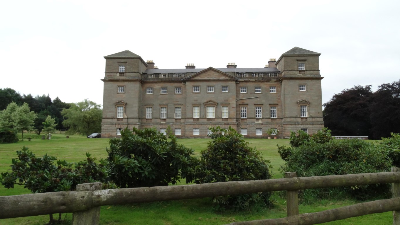
Imposing Hagley Hall which dates from 1754

The quiet churchyard of St John the Baptist Church at Hagley.
After a brief look inside the church I am off again. In Hagley I have to cross the busy A456 which is not exactly an easy task to negotiate this busy dual carriageway. I next take the path up to Wychbury Hill passing on the way a slender obelisk with a very stout fence to keep away anyone. Wychbury Obelisk rises to a height of 84 feet and was commissioned by Sir Richard Lyttelton, a son of the elderly Sir Thomas Lyttelton, owner of nearby Hagley Hall. Construction was started in 1747 and the monument is grade 2 listed. More recently the monument has suffered much graffiti and there were proposals to demolish it due to safety reasons but the monument has since been restored. I take the path leading down to Pedmore and I can imagine this would have proved a nightmare if it had been wet as even now it is quite churned up but thankfully the mud had dried out somewhat.
To reach the centre of Stourbridge I have a mixture of road and path walking and after following some residential roads I find the somewhat unsigned hidden entrance to Ham Dingle, a narrow wooded ravine along which runs a path but sadly the dumping place for much garden waste and other rubbish. Once across the A4036, surfaced paths lead to Old Swinford which has some fine old houses and an impressive church which I find locked. Off-road way-finding into Stourbridge proves a bit of a challenge and at one point I have to back track but eventually emerge at the new bus station. If I had done some research earlier I could have taken a short ride on the Parry’s Peoples Mover, an almost unique bus type vehicle which runs on the standard gauge railway and connects Stourbridge Town Station with Stourbridge Junction which at 0.8 of a mile is the shortest branch line railway in Europe and at £1 per journey is probably the cheapest rail fare you can buy in the this country. Oh well, I shall have to come back I thought.
Now Stourbridge on a grey and slightly wet Sunday afternoon is not all that appealing. I wander down the main shopping street and despite Sunday trading, many shops are closed and not many people about. I soon head out of the town and join the deserted towpath of the Stourbridge Canal, a rather empty backwater with little of interest. This area is known for Stourbridge Crystal, – a fine glassware. By now I realise that I had timed the bus to Wolverhampton badly and rather than wait for nearly an hour I decide to extend my walk by walking through Friar’s Gorse and coming into Wordsley from the west and hence not waiting for a bus too long. The number 256 is running to time and is fairly empty and I take a seat upstairs at the front for the trip into Wolverhampton. I have just time for a visit to McDonalds in the town before catching the train back home.