

Ponies in a snowy field near Rudry.
If you didn’t live in Cardiff or Newport you would probably not consider walking in this area but as you know, I am always looking for different areas to walk and a few years ago I chose to explore that wedge of hilly land which is hemmed in between Cardiff and Caerphilly.
It is a glorious sunny February morning when I set off across the Severn Bridge and leaving the M4 near Newport I take back roads to reach the tiny village of Rudry. The hilly areas are snow clad and look most inviting, but this is beginning to melt in the morning sunshine.
Parking in the deserted car park on Rudry Common I take a path eastwards across the common before crossing the road I had driven on to get here. I later attempt to turn right on a path to reach Rudry. This is easier said than done as the path running to Rudry simply doesn’t exist despite the area being close to the Welsh capital. I cross a fence and walk down through some woodland but this becomes more and more difficult and in the end I have to cross another fence and then a second fence to gain the hamlet of Rudry. I now make a small diversion to visit St James’s Church at Rudry. Founded about 1254AD, this attractive grade II listed church started out as a wayside shrine used by pilgrims. There is a unproven myth that Oliver Cromwell sought refuge in the building during the English Civil War.

St James’s Church at Rudry dates from around 1254AD.

A Christmas card scene on the Rhymney Valley Ridgeway Walk.

Winter delight. On the Rhymney Valley Ridgeway Walk near Thornhill.
Leaving the hamlet I take a path south to a wooded ridge. At the top I turn right to follow the Rhymney Valley Ridgeway Walk westwards. This 28 mile long recreational path runs largely along the skyline around Caerphilly. On this hilly stretch there is snow cover on the ground and with the bright sunshine, it makes for some very pleasant walking. For the next mile I continue through woodland before crossing a snow covered minor road which is hardly recognisable as a road. Ahead I walk along the ridge known as Cefn Onn and meet several other walkers and this is a good spot to stop for my morning break. I press on westwards and skirt an old quarry on its the north side and continue through more attractive woodland with the trees coated in snow although much of this is falling off in big lumps as I passed. At Thornhill I cross the busy A469 and soon reach a snow covered golf course. It is lucky that there is no play today as I find way finding here a bit of a problem and now have to search around to find my intended path. I have to deviate again later as the path towards Caerphilly Common doesn’t exist. I head further west before crossing Watford Road and making for the summit of Caerphilly Common on thankfully a good path. The summit is crowned by a trig point 271 metres and today there are good views and worthy of a few photographs and furthermore, this spot is popular with other walkers. It is a bit too cold for lunch on top and so I set off on what I think is the path which will lead me down to Caerphilly. I find that the paths in the area, and what is shown on the map don’t agree and I in trying to follow my route, I find myself on another golf course. Luckily again due to the snow cover the place is deserted and I skirted around the lower hillside to join my intended route.

On a snowy Caerphilly Common before descending towards Caerphilly.
It is now road walking into Caerphilly and down the main shopping street towards the castle. I find a seat overlooking the moat for a picnic lunch a bit away from the crowds but by now it has largely clouded up. Think of Caerphilly and you are likely to think of its castle or its cheese. The castle is impressive to say the least and is the second largest in area in Britain, and has the most elaborate moat system of any such castle. The present building dates mostly from the 13th century and was constructed by Gilbert de Clare in an effort to control the area called Glamorgan from his rivals. Over the centuries the castle saw several sieges and finally fell in to decay around the 15th century. Its famous listing Southeast Tower was caused by subsidence but made worse by the damage caused by Oliver Cromwell during the English Civil War. The lean is greater than that at Pisa.
Caerphilly is also synonymous for its cheese which consists of a hard crumbly white cheese originally produced at local farms around the town to provide food for local coal miners. Production of the cheese stopped during World War II but has since made a comeback.
Comedian Tommy Cooper was born in Caerphilly and a statue to him complete with Fez overlooks the castle. Before I leave this interesting town I make a quick visit to the Tourist Information Centre.

Impressive Caerphilly Castle, the second largest castle in Britain.
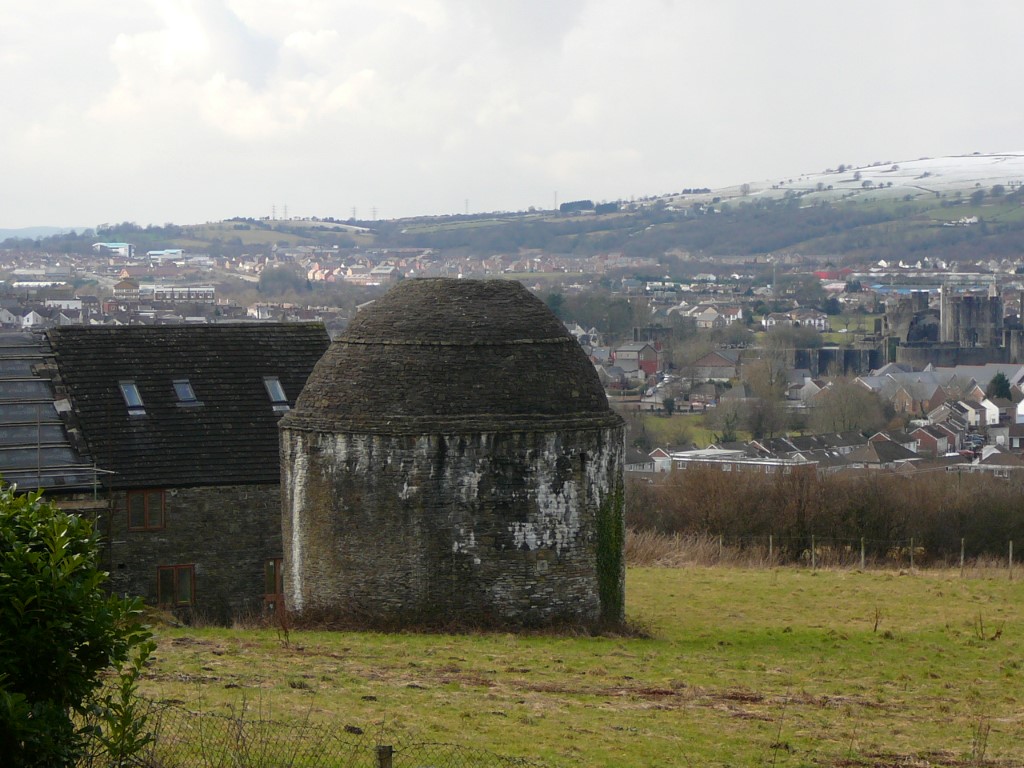
The dovecote at Castell y Fan on the edge of Caerphilly is said to be one of the best of its kind in the country.
I now follow a track eastwards towards Gwern-y-domen and on the way I branch right across fields however in the third field the going proves impassable due to the waterlogged ground. Like previous walkers on this path, there is an easy way through an adjacent field. Once over the Nant Gwernybara via a new footbridge I am soon on common ground and I shortly veer up to the right before a long steady ascent to bracken covered Mynydd Rudry 222 metres. Much of the snow cover from earlier has gone by now and from the top of this modest summit it was only a short walk back to the car after a walk with more than its fair share of path issues.