The Middle three

Setting off along the track to Loch a Bhracin in perfect weather conditions.

In theory and with transport at either end, it would be just feasible to climb all the nine Munro’s in Fannichs in just one day but a few years ago I had planned a week based in Ullapool which included a plan to climb all the Munro’s in the Fannich’s as circular walks over three days but after a week of fairly wet weather with much low cloud I had only managed two of the nine Munro summits and then they were into the cloud. On that week many of my walks were low level.

Last May I was now back with NickWild and in much better weather we decided to bag the middle three Munro’s in the group. The other four eastern summits we would climb a few days later, also in very good weather. Like my previous visit, I parked in the same place and today the car park was already almost full.

The footbridge at the eastern end of Loch a Bhracin crossed on both outward and return routes.

From a high point on the A832 above Loch a’Bhraoin we took the good track down to the loch. Here I discovered that my camera battery was flat but it wasn’t worth going back to the car so I would just have to take poorer quality photographs all day on my mobile phone.
The day was already warm as we continued up alongside the upper reaches of the Abhainn Culieig and after awhile we had to cross this stream which was just about shallow enough to cross without removing walking boots. We lost the path further up and took a sketchy path far too close to the stream before realising that the path was well above us. Close to an attractive waterfall we cut up across rough ground to reach the intended path. We now followed this up to a rather windy col where we found some shelter for our morning break.

A waterfall on the Allt Breabaig with Sgurr Breac towering above. Most walkers don’t see this waterfall, but at this point we were following a sketchy path below our intended path.

Heading generally south southeast we next took the easiest route to the ridge south of Sgurr nan Each, the most southerly Munro in this middle group of three. Another party of three who had followed us up the valley but at a distance took a more direct route to the col at Cadna na Guite but from what we could see, it looked like quite a toil for them.
As for us, it was a straightforward ascent to reach the col at Cadha Dearg Mor. To the south lay the shapely Sgurr a’ Chadha Dheirg. Meanwhile we turned north up the easy southern slope of Sgurr nan Each which at 922 metres was our first Munro of the day. We took a leisurely break and the other party of three soon reached the summit. They were doing a very similar walk to us and we would pass one another several times during the day.

A morning break on the first Munro at Sgurr nan Each (923 metres) and now joined by another party doing a very similar walk to ours.

Nick and I set off first and headed north on the curving descent to Cadha na Guite and ahead lay a long ascent of around 280 metres to the summit of Sgurr nan Clach Geala which at 1093 metres is the second highest summit in the Fannich group. A path led up the mountainside and zigzagged most of the way. We took it easy pausing now and again in the warm sunshine. A massive snow block was lying precarious on the craggy slope to the right and was melting so quick that water was running off of it forming a small stream below. Eventually we reached the south eastern spur of the summit which meant an easy walk to the top. The other party were well behind us when we looked back.

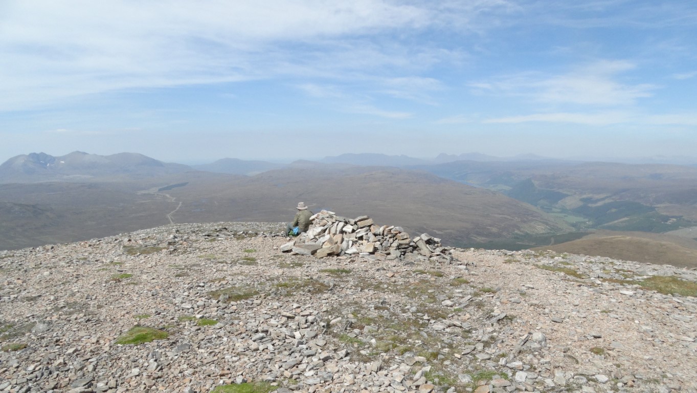
The summit of Sgurr nan Clach Geala which at 1093 metres is the second highest summit in the Fannich group.

The summit which was crowned by the remains of a trig point was our lunch stop and we chose a perch facing west on this glorious sunny day. There was no need to rush as we had made good time and the bulk of our walk now would be downhill. Sitting on the summit we couldn’t have chosen a better day.

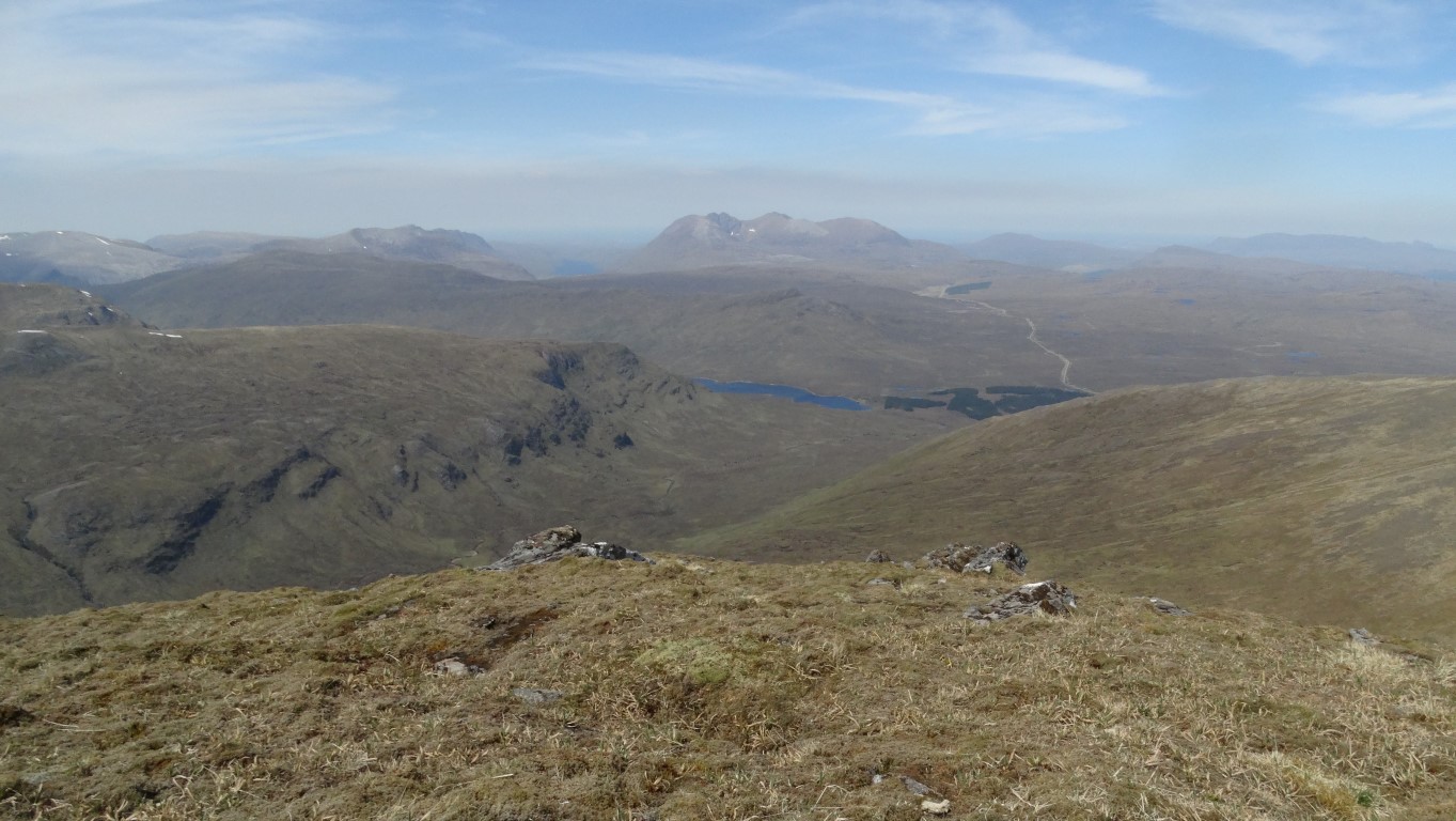
Our lunch time view from the summit of Sgurr nan Clach Geala looking towards An Teallach. We had started out from the right hand side of the woodland block which is visible middle right.

Over lunch the other party came by but carried on down the northern eastern slope. We soon followed and caught them up and overtook them as they stopped a long awhile in Coire Breabaig and chatted with another couple of walkers. We pressed on across more level terrain before making the easy ascent to Meall a’ Chrasgaidh which at 934 metres was the last of the three Munro’s we were bagging today.

Time for an afternoon break on the summit of our last Munro of the day – Meall a’ Chrasgaidh (934 metres).

After another break we decided to head off west descending the very easy slope. It was just like walking over a deep piled carpet and from the top to the path along the valley we managed it in just 38 minutes, – a descent of almost 600 metres.
We now followed the correct path back and re-crossing the Abhainn Cuileig at the same point as before. From this point, a good path and later track led back to the car. It wasn’t even 4pm and it had been a day where we had made exceedingly good progress in perfect weather conditions.

Rounding off a perfect day with this sunset over Loch Broom as views from our self catering establishment at Ullapool.

A journey through time

Repton Market Cross marks the centre of the village.

Repton is a fascinating place and has a long history. Today this large village is dominated by its famous school. Founded in the 1500’s the school was built following the bequest of Sir John Port of Etwall who died in 1557 on condition that students prayed daily for his family souls. Repton Priory was to be the location for the new school in 1559 but for the following century there were lawsuits between the local landowner and the school which were only resolved out of court in the middle of the 1600’s.
The church of St Wystan is famous for its Saxon Crypt which is said to be one of the most precious survivals of Anglo-Saxon architecture in England. The crypt was forgotten about for many centuries and was accidently rediscovered when workmen digging a grave stumbled upon it. It is thought that three Royal Saxon King’s were buried here.

For my walk I started out by visiting Repton Church as I was keen to take a look at the crypt. Being a August bank holiday, the school was closed and hence the village relatively quiet.

I headed out of the village on the Milton Road and soon turned left on a side road before taking a path east over Askew Hill where I went in search of the trig point which I found easy to locate. The path east however ran alongside a field of tall maize before cutting across another field of even taller maize with a path only just wide enough to get along. I was just glad that this crop wasn’t wet. I next had some road walking east to Windmill Hill where I turned left a little too soon and had to back track before taking the correct path towards Anchor Church.

Anchor Church is not so much a church but a series of caves hewn into the cliff face and once thought to be the home of a hermit.

This path later ran below a low cliff which was once the southern bank of the old course of the River Trent. Further on, the cliffs were higher and directly overlooked the river. The downside here was the dense growth of Himalayan Balsam. I wanted to explore Anchor Church which is not really a church but a series of small caves hewn out of the conglomerate sandstone rock. The name is thought to derive from the Anchorite hermit St Hardulph who lived here in the 6th or 7th centuries. In the early eighteen hundreds the caves were enlarged by the then owner.

Setting off once more I had to make a short but steep ascent up a slope to the cliff top and walked along the edge with a steep drop to my left before briefly descending to the river again. Beyond, a pleasant path led to the road at the small village of Ingleby.

Poppies line the edge of a field south of Ingleby with a distant view across the Trent Valley.

From here I set off south towards Ticknall on pleasant well defined paths with some views back over the Trent Valley. On the way I passed Knowle Hill, once an Italianesque pleasure garden which was created around 1700 and was designed to blend in with the local landscape. Today only a cottage and the summerhouse survive and the premises were acquired by the Landmark Trust in the early 1990’s and partially restored.
After crossing a few more fields full of swallows darting here and there and passing through woodland blocks I arrived at Ticknall. A brand new wooden seat was a good spot to stop for lunch.

A display board in Ticknall depicting a wealth of historical information.

Ticknall was originally the estate village of the nearby Calke Abbey and the area has a long history of brick-making. Afterwards, I headed into the village passing on the way one of the ‘Ticknall Taps’ which the village is famed for. Around the village is fifteen such water spouts, each are an identical cast iron green spout with a lion emblem on them. They were part of a public water supply installed on the instruction of Sir Vauncey Harpur-Crewe in 1914. I decided on this occasion to visit the village church which was built around 1842. In the churchyard are the ruins of the medieval church which fell in to disrepair and rather than restoring it, the Victorians built a new church and blew the old church up leaving just a few ruins among the gravestones.

So what do you do with a redundant medieval church in the churchyard – well the Victorians simply blew the old church up leaving these remains.

One of the unique village pumps in Ticknall.

Heading northwest from this fascinating village, I set out on the National Forest Way. I had walked this path in the opposite direction a year earlier and today I paused here and there to pick a few blackberries. With a colourful patchwork of the ploughed fields, the afternoon had turned quite grey and it felt that summer was over as I trekked through pleasant countryside and later crossing a road south of the village of Milton. I continued west on a field path before turning north passing historic Ridgeway Farm and its listed dovecote on the outskirts of Repton. At the Mount Pleasant Inn, I turned left down a hidden enclosed path before turning right on a path through an overgrown area and passing a fine apple tree on the way with much fruit ready to pick. Another hidden path was followed into the village to complete a very rewarding walk.

Gently rolling countryside and patchwork of colours is a typical scene in this area.

‘Take your pick’. This apple tree in a long gone orchard was loaded down with fruit as I neared Repton towards the end of my walk.

I am repeating this walk on the 6th April with one or two small variations so why not join me on a walk full of fascinating history. In Ticknall we will divert to visit the old lock-up and will view Sheffield House which is not all that it seems.

Sheffield House in Ticknall. Find out why this house is not all it seems when you come on my walk.

Curious Lakeland pillars

Haweswater Siting Pillar on Artle Crag. One of five which lie in a perfectly straight line between Haweswater and Longsleddale.

A few miles north of Kendal lie one of those less frequented valleys in the Lake District. Turning off the A6 near Garnett Bridge you are soon in another world of narrow lanes and high hillsides. This is Longsleddale but to get to the upper end involves a somewhat tortuous drive along four miles of very narrow lanes with few passing places so you hope you are not going to meet a tractor. Thankfully on this occasion I had a car following me and its driver seemed in no hurry to get past. As it turned out he was just another walker who parked up at the road head close by me.

I had long planned a hill walk from the head of Longsleddale but owing to poor weather earlier in the week with extensive hill cloud I was thankful that I had re-scheduled the walk until today.

I needed to be early to get parked up at Sadgill as parking I knew was limited and indeed it was as several cars were parked there already. There is limited parking beyond the end of the road but this is along an extremely rocky track which wouldn’t do the car any good.

A secluded barn at the isolated farm at Stockdale close to the start of my walk.

Setting off back down the lane a short distance, I soon took an enclosed path up to the attractive farm at Stockdale. At this stage I was unsure if there was a way onto the open access land and I was pleased to see new signs making the route straightforward. Also in my favour was the good quad bike route up onto the open fell which made the going much easier through the bracken. I wanted to take a look at the Haweswater Survey pillars which run in a straight line from Longsleddale to Haweswater Reservoir. They were built in 1926 on the line of the aqueduct that supplies water bound for Manchester.

The second Siting Pillar above Longsleddale which I dropped back down to for a closer look. I had climbed too high on this warm morning to visit the first pillar which is situated well below the pillar seen here.

The day had already turned warm and no need for a jacket early on. I ascended quickly and soon found myself far too high to take a look at the first survey pillar. A small diversion downhill took me to the next pillar. Back on track, I now followed a path cum quad bike track which led uphill towards Grey Crag which made the access easy going all the way to the 638 metre summit. On top I paused for my morning break. To the northwest, Tarn Crag was crowned with another survey pillar but to get there I had to cross an area known as Greycrag Tarn, which was not so much a lake but a marshy col marked with several ominous marsh symbols on the Ordnance survey map. All paths on the ground tended to lead towards the line of the fence and so with the dry weather I chose this route. The so called ‘tarn’ had dried out insomuch I could have crossed the area in town shoes. The path continued, following the fence to the top of the ridge before veering left and making for the summit of Tarn Crag (664 metres). The survey pillar was located a little west of the summit and was a much bigger structure than the first survey pillar.
To reach my third summit – Selside Pike, I next descended to the col before ascending steeply up Selside Brow. Part way up I left the path and crossed a wall and fence and made out across rough country to the third survey pillar near to Artle Crag. The going wasn’t exactly easy under foot and I had to ascend higher than hoped to avoid long vegetation.
To reach Selside Pike, I followed a path which led over the un-named summit at 673 metres before later making a short ascent to the 655 metre summit.

The siting pillar on Tarn Crag lies on the western edge of the summit.

It was now time to back track and head to the highest summit of the day at Branstree (713 metres). It was an easy walk with a good path the whole way. I had planned to have lunch on the summit but by now the wind had become too strong to make it comfortable. The summit is unusual as it is marked by a Ordnance Survey concrete ring – the first that I had come across. In the whole country there are just nineteen such markers, most of which are in this area.

Not your usual trig point. This is an Ordnance Survey Concrete Ring, – one of only nineteen in the country. Just as well it wasn’t covered by snow!

I decided to descend and have lunch at Gatescarth Pass. It was an easy descent except for the last little bit across a rather boggy col. The top of the pass was also breezy but I found a northwest facing spot out of the worse of the wind. Thundery weather had been forecast for later in the day but for now there was no sign of it. With time on my side I could make the walk back at a leisurely pace. I joined a track which initially descended steeply to Brownhowe Bottom passing on the way the disused Wrengill Slate Quarry. The quarry is close to the north eastern limit of green slate workings in the Lake District. This type of rock stretches across the southern Lake District to the Duddon Valley.

A lazy afternoon in Longsleddale. The track wanders along this peaceful valley. On this sweltering afternoon the peace was briefly shattered by a low flying jet.

I pressed on at a leisurely pace beside the upper reaches of the River Sprint and I had to stop the temptation of an afternoon paddle in one of the inviting pools. Below the Buckbarrow Crag the track levelled out but there were numerous twists and turns to get back to the car. Along this section I witnessed a low fly pass by a training jet which briefly shattered the peace and quiet of this hot and sunny summer afternoon.

Drama on the Quantock’s

The parish church of St Mary’s at Kilve, the first of three churches visited on this walk.

Cast your mind back to those few balmy days of late February which now seem a distant memory. It just so happened that I was down in the West Country which gave me the opportunity to walk another section of the Somerset Coast Path. Having started in Bristol a couple of years ago on my frequent visits to the southwest, I have been walking the coastline down towards Minehead and to date I had reached Kilve Pill which meant with just two more walks I would achieve my goal. During much of this time the newly opened coast path had been closed due to a rock fall at St Audries but according to the up to date website it had now re open.

I had two plans;- If the weather was dull and grey I could have walked from Watchet to Minehead along the coast then caught the bus back, or secondly if the weather was fine I could park up in Kilve and walk down to the coast to rejoin where I left off before Christmas at Kilve Pill and follow the coast to Watchet and return over the Quantock Hills making it a fairly long walk, but feasible on a fine winter’s day. As the weather was set fine, I chose the latter so what could go wrong? As we shall see, this walk didn’t go to plan.

Parking up at the Village Hall in Kilve I opted to take the field path running past East Wood down to the village church at the remains of Kilve Chantry. Here I followed the track down to the coast at Kilve Pill to pick up where I had got to on my last walk in the area late last year.
Setting out west on the coast I immediately came across two signs, one saying the path west was closed due to a rock fall which I took as being out of date information but secondly, metal signs stating that the coastal path was impassable a couple of hours either side of high tide at two locations;- firstly at St Audries Bay and secondly at Helwell Bay prior to Watchet, both places that I would be passing.

What a place for my morning break with just the sound of the waves crashing on the shore and the warm February sunshine on your back.

I soon stopped where there were some seats for my morning break overlooking the coast with the sound of breaking waves. For now, I opted to press on west along the coastal path but it was soon obvious from the cliff top path that the tide was well up and still coming in.
I followed the coastal path west over Quantock’s Head but a half mile further west, it was obvious that the tide would be too high to stay with the coast as the sea was already up to the base of the cliffs looking west to the headland at Blue Ben. I would need to turn inland and do this coastal walk on another occasion and check the tide times prior on the next time that I intended doing this walk.

This is the point where I decided to leave the coast path. With the tide coming in my route ahead would have been blocked. The tide is already up to the base of the cliff at Blue Ben in the distance.

I now followed a concessionary path south and later crossed the A39 to join a minor lane up to a point where a cottage was being thatched. I chatted with the owner before pressing on to skirt the northern edge of the open access on the Quantocks. The path eventually led around to West Quantoxhead but ran just above the busy A39 and hence it was rather noisy. The path route also didn’t agree with my Ordnance Survey map despite having the latest Explorer edition of the map.
At West Quantoxhead I opted to divert down to take a look at the attractive church which despite the busy road nearby is set in a sunny fold of the Quantock Hills. I took a look inside this small Victorian church which is dedicated to St Ethelreda or St Audrey – take your pick.
Heading southwest I took the road into West Quantoxhead standing in for a fire engine racing to somewhere. In the village I turned left uphill on a minor lane. Nearing the car park at Staple Plain I discovered that not all was well as ahead of me the moorland was on fire.

A pause to visit the church at West Quantoxhead on this warm February day. An idyllic spot but is marred by the A39 which runs just behind the church.

Reaching the car park I stopped for an early lunch on a bench. My plan had been to get to the top of Beacon Hill before stopping for lunch. Over lunch I observed the smoke billowing up on the moor ahead of me. Going over Beacon Hill was certainly out of the question and a stiff breeze was fanning the smoke from the southeast. I pondered over lunch which way I needed to go. I could still get through to Bicknoller Post on the western side as that seemed the only route free of smoke then skirt around to the south of the moorland fire but if I was forced off the hill I would be on the ‘wrong’ side of the Quantocks to my car.

Leaving the car park at Staple Plain, more fire engines soon turned up. For now I kept an eye on the fire burning over to my left. Reaching Bicknoller Post I was now southwest of the fire which was burning on Longstone Hill. My only real option was descend through Sheppard’s Combe and later Hodder’s Combe. It was a lovely sunny afternoon as I descended through the peaceful valley in the warm February sunshine but I noted that the dead bracken was tinder dry but here I was out of the cool breeze blowing over the hill top. The place was deserted and it was a pleasant walk down through the woodlands. At the foot I briefly took a wrong turn and had to back track. I wanted to make a short diversion to visit the church at Holford. Much of the building today dates from the 16th century but there has been a church on this site for over a thousand years. I took a look inside before sitting in the peaceful churchyard for my afternoon break. Back in the village I took a side path which dropped down to a footbridge which spanned a stream in Holford Glen. Beyond, I joined the Coleridge Way briefly before taking a field path down to Pardlestone Lane which I followed down to Kilve and passing an activity centre on my left on the way.

Rounding off the day at the historic St Mary’s Church at Holford. I sat awhile in the churchyard in the warm February sunshine with only the sound of ravens in the trees.

The Coleridge Way is a fifty mile long recreational path way marked with a quill pen which runs from Nether Stowey in Somerset to Lynmouth in North Devon. The path runs through areas which have connection with the poet Samuel Taylor Coleridge and passes through some attractive villages in deepest Somerset and well off the tourist trails so this may be worthy of walking when I get the time.
I had completed a good day’s walk in excellent weather but not the walk I had set out to do.

Tour of Stockport Air Raid Shelters Friday 10th May at 2 p.m.

Tour of Stockport Air Raid Shelters Friday 10th May at 2 p.m.

Demand has been so great that an extra tour has been organised to run simultaneously, but in the opposite direction. Consequently there are places again available.

Age 65 and over £5.75 pp.
Under 65 £7 pp.

To reserve a place contact Brian Griffiths at minigriff2@yahoo.co.uk

Weekend Away to Pickering October 18 – 20 2019

Featured


Pickering is an ancient market town  in the Ryedale district of North Yorkshire, England, on the border of the North York Moors National ParkHistorically part of the North Riding of Yorkshire, it sits at the foot of the moors, overlooking the Vale of Pickering to the south. The town as it exists today is of medieval origin.  From Pickering there is easy access to the North Yorkshire Moors by road, bus or train.

Walks

I hope to offer the 3 grades of walks on both days and would be grateful of offers to lead walks. I know the area quite well and will be able to help with suggested walks.

Saturday Group Evening meal

This will be at the Forest and Vale Hotel. We shall have sole use of their attractive dining room.  I will circulate a meal choice form in due course, the cost being around £26 for 3 courses and tea/coffee.

Friday evening meal

There are many pubs in Pickering plus other places to eat but I can organise a group meal in the Forest and Vale hotel which will be simple. E.g. Pie and chips or Fish and Chips details to follow later.

Sunday evening meal

The hotel does meals in the brasserie/bar and it will be possible to arrange tables and times to eat.

Accommodation

Forest and Vale Hotel – this is a very pleasant hotel situated on the roundabout between of the A170 and A169 close to the town centre with parking. They require us to occupy a reasonable number of rooms in order to have the main dining room on the Saturday evening.

Cost of rooms is for Bed and Breakfast with Tea/Cake on arrival and is as follows

Standard                         £230 2 nights                        £345 for 3 nights

Executive                        £261                                        £391.50

Superior                        £290                                        £453

A double room for single occupancy is £20 a night cheaper per room.

To book please contact the hotel 01751 472722 and mention ECR as they reserved rooms until the end of January for us to book. You will be asked for a deposit.

Other accommodation

Looking on the Internet you will find plenty of B and B’s plus self-catering accommodation. Pickering is a popular town and so much of it is of a high standard but not cheap. I visited nearby places

1. Black Swan – close by 9 rooms well reviewed and looked pleasant. Have a single at £70/ night or single use of double for £85.

2.Cawthorne House – £75single/night £85 double

3.Grindale House – also have cheaper single rooms

4.Bramwood Guest house – fairly close slightly cheaper than hotel.

Please let me know:
1.      if you will be coming
2.      where you will be staying

3.   your email or other contact details so that I can send you the updates on the walks and the Meal.

Ann Thompson,  email: athompson@email.com

The other London Airport

Slipping out of Kirkwall Harbour early in the morning en route to the Island of Eday.

Poring over maps as I so often do, I conjure up a ‘3 D’ picture in my mind of a certain area and one such area had long been the northern tip of the island of Eday in the Orkney Islands. A prow of land shaped like the bow of a ship culminating at the trig point at Red Head. I have long been intrigued by this location and promise myself that it was high on my visit list.

Eday is just ten square miles and has a population of around 130 inhabitants and is the ninth largest island in the Orkney archipelago. The island lies around fifteen miles north of the Orkney capital Kirkwall.

A distant view towards Red Head at the northern tip of Eday.

Planning a day trip to Eday with my son Stewart back in 2013 during a week long trip to the Orkney Islands meant we were restricted to Wednesday due to the ferry timetable and so I was banking on good weather. My initial plan was not to take the car to the island but with the weather being somewhat doubtful and the island having little if any shelter, it was worth spending the extra few pounds to make a day of it and if needed have the shelter of a car if the weather took a turn for the worse.

The ferry meant an early start as we had to be in Kirkwall by 06.30am for the rather long trip via the island of Stronsay. It was after 9am by the time we were disembarking on Eday and then in a rain squall. We drove north up the island spine road, the empty B9063. This was an area that even Google street level mapping hadn’t reached! Our main aim was to get a good walk in but parking proved a problem as most lane endings finished at a farm entrance. In the end we found a small car park at the bird hide by Mill Loch. It was time for our morning break as another rain squall moved through but the weather looked good after that. The Ranger for the island turned up and we chatted awhile. She was surprised to see ‘tourists’ as she estimated that we were about the eighth tourist this year.

Stephens Gate, a natural arch on the eastern side of Eday was passed early in our walk.

Stewart and I set off on our walk along the lane towards the hamlet of Hammerhill to visit the island shop. I am always interested to see how well stocked these places are and the variety of goods on the shelves. As well as the range of foods these shops are like mini department stores. It was now for some serious walking as we took the track behind the hamlet towards the coast. The track degenerated into a path which later disappeared altogether but at least wooden marker post kept us on the correct route. Turning north we followed the coast passing Stephens Gate, a natural arch on the low cliffs. Further on we passed a couple of sea stacks called The Castles where a stout barbwire fence separated us from the cliff edge and so views were limited. We had to turn away from the coast here before a right turn along a grassy track to the deserted B9063. A left and right turn took us along another lane via Carrick Farm to the historic Carrick House. This was the location where John Gow, the notorious Orkney Pirate luck ran out. His life started as a deck hand on one of the many ships which plied out of Stromness but on one trip, and with bad feelings running high, he and others mutinied and killed the captain and other senior officers before renaming the ship ‘Revenge’ and carrying out piracy on the high seas and so Orkney has its own ‘Mutiny on the Bounty’ story. John Gow took his pickings by raiding prosperous houses on the coast but came unstuck when he chose to take the rich pickings form Carrick House in 1725. His ship ran aground and he was overpowered by staff and islanders. His fate was that he was tried in London for his crimes and along with other accomplishes was hanged. Today Carrick House overlooks Calf Sound in much more peaceful times.

Carrick House overlooks Calf Sound and the location where the notorious pirate John Gow’s luck finally ran out.

The Calf Sound Lighthouse towards the northern end of Eday set on the edge of a aquamarine sea.

Heading north, Stewart and I now followed the shore with a brief stop at the Calf of Eday Lighthouse. The path ahead petered out and so we made our way uphill to follow a better path along the ridge to the trig point at Red Head. Despite its modest 70 metres above sea level, the headland afforded far views to the islands of Westray, Sanday and North Ronaldsay set in a aquamarine sea. Thankfully we had picked a perfect day and we were being blessed with sunshine. The headland as such was surrounded with a new and stout barb wire fence and not easy to cross, but I ventured out to the headland not that you could see much of the sandstone cliffs.

Red Head at the northern end of Eday. It may be only 70 metres above sea level but the views on this day were magnificent.

Setting off once more we followed the coast south westwards before turning towards Vinquoy Hill by which time it was turning into a really fine sunny afternoon. As we followed the hillside along to the summit of Vinquoy Hill the views across Calf Sound were spectacular and we could hardly believe our luck to get such good weather. Along the ridge of Vinquoy Hill we came to Vinquoy Chambered Cairn. We could crawl inside to the main chamber of this perfectly preserved chambered cairn. A short walk took us downhill across one or two areas of boggier ground but thankfully with board walks to reach the Stone of Setter, Orkney’s tallest standing stone at 4.5 metres. Finally it was back along the road to the car then to spend the rest of the day exploring the rest of the island including a shorter walk around War Ness at the southern end of the island and up to Ward Hill, which at a modest 101 metres is the highest point on the island.

Vinquoy Hill Chambered Cairn which you can crawl into.

The Setter Stone which at 4.5 metres tall is the highest standing stone on the Orkney Islands.

Heading back down the spine of the island there was another place worthy of a visit. The tiny airport on the island is just so located at a spot called the Bay of London and hence is named London Airport. So imagine this London Airport with free parking, absolutely deserted, and no aircraft.

I managed to get to the ‘airside’ without being spotted by security. This is the other London Airport.

A wooden direction indicator on Ward Hill near the southern end of Eday.

Returning to the ferry terminal it had been a great day out to a place in the British Isles where few venture.

Group walk report 13th February

 By Peter & Georgie Everson

Photographs courtesy of Sylvia Hill

A pleasant early spring day was on the forecast, but when we reached Dennis Knoll Car Park near Hathersage there was a biting cold wind. Ten of us set off up the track to Stanage Edge and across to the Stanedge Pole. As we dropped down towards Redmires Reservoir we found a sheltered grassy bank for our coffee stop. Unfortunately the Reservoir has been drained while work on the dam is being carried out. When we reached Wyming Drive the wide track took us along the river joining Redmires and Rivelin Reservoirs. We left the drive at a path marked Reddicar Woods and climbed steadily onto the moors. In front of us was the Headstone. This is a naturally occurring block of grit stone surrounded by a sea of smaller rocks due to many fractures in the rock. The views across the moors towards Sheffield were magnificent. We could also see Crawshaw Lodge across the Valley. We climbed up the fields to it and then turned left along the Roman Road.
We had lunch sheltering behind a wall with great views towards Hallam Moor. We soon reached Moscar Lodge and then crossed the A57 to reach the path up to Stanage Edge. Again we had good views towards Ladybower Reservoir, Win Hill and Fairbrook Naze. We followed the path below the rocks which gave us lovely views of the edge with winter sunshine on them. Just before we dropped down to the car park there were millstones all over the hillside in the bracken.
Millstone production was one of the main industries in the Peak District starting in the 14th century and reaching its peak in the late 17th century. It disappeared suddenly in the mid 18th century when white bread became fashionable. The gritstone turned flour a grey colour whereas French millstones were capable of producing white flour. The stones now lie exactly where they were made and are now the emblem of the Peak District.

The group on High Neb with a view towards Win Hill and Ladybower Reservoir.
Stanedge Pole and the bleak moorland.
The party walking on a cold day near Stanedge Pole.
A old milestone on the Sheffield Road together with a bench mark.
Finished millstones lie amongst the bracken below Stanage Edge.
The Long Causeway at Stanage Edge.

Group walk report 2nd February 2019

A recent East Cheshire Ramblers walk started at Alderley Edge. This was once reported to be the “Champagne Capital of Britain” due to its many famous residents. 13 ECR members started to climb to “The Edge” up a cobbled road, flanked by imposing houses, testifying to the aforementioned residents. Leaving the cobbles, we went along a short path to enter the National Trust land. It is a site of Special Scientific Interest because of its geology and history of copper mining dating back to the Bronze Age, and it is also known for its wizard myth, which inspired the novel “The Weirdstone of Brisingamen” by Alan Garner. We walked past the Wizard’s Well where, if you look carefully, you can see the outline of a wizard’s face and the words, “Drink of this and take thy fill for the water falls by the Wizards will”.
From here we walked past the Armada Beacon, one of a number of beacons set up in Tudor times, to act as an early warning system throughout the country. Next, it was on to Stormy Point, from where there were magnificent views of the Cheshire countryside as there was on our walk. We then we descended to cross the Mottram road. Our route then took us along field paths, first in a northerly and then in a north easterly direction passing several farms, until we reached the A538 which was followed for a short distance. Continuing north- easterly we reached Mottram Bridge and then Bonis Hall Road, where we turned to the south east and used field paths again to walk almost parallel to the road to reach Top o’th’Hill Farm. From here we changed our bearing again and walked south west, crossing the Bollin Valley Way to crossing the edge of the Mottram Hall Golf Course on our way to reach and join the North Cheshire Way, a long-distance path which starts near Ellesmere Port and ends in Disley. We followed this path for some time, skirting Hare Hill, another National Trust property, before arriving back at “The Edge” and having a well-earned break in the picnic area near the car park. From here it was just a question of descending to Nether Alderley and then following the path parallel to the Chelford road to arrive back at our starting point.

The glorious snowy view from Alderley Edge.

Most of the group gathered around the Armada Beacon on Alderley Edge.
Descending from Stormy Point.
Morning coffee break near Hough.
Making the most of the winter sunshine during our lunch stop near Hunter’s Pool.
Some one who tagged along on this walk!

Encounter with the ‘Grey Man of High Wheeldon’

Encounter with ‘The Grey Man of High Wheeldon’ or is this my own shadow.

Just once in awhile you pick one of those days for a walk which unknowingly when you set out has that extra ‘ingredient’. On this occasion it was moisture which made all the difference as we shall see.

With the prospect of a really fine sunny day last week I decided at fairly short notice to go on a walk in the Peak District. I wanted to go somewhere not too far away and yet explore some new places. On High Wheeldon was a trig point that I hadn’t recorded a visit although I had been there some time in the past, and secondly the hill known as Carder Low which had some open access looked an area worthy of including in my walk. With this in mind, I set off with the aim of parking in Monyash.

Driving up to the Cat & Fiddle I noted that the Cheshire Plain was choked in a cold air inversion and the mountains of Wales stuck out clearly beyond. Ahead of me I was surprised to see another cold air inversion to the east but for now I felt that Monyash would be high enough to be above the fog ceiling. My journey down the A515 revealed otherwise as I drove from the bright sunshine into the gloom. Indeed Monyash was well into the fog but with a good weather forecast I expected that the fog would soon disperse. I donned warm walking gear in a temperature only just above freezing and set out from the village in very poor visibility. The sun was just a pale disc in the sky and heading west and walking back along the B5055 so the sunlight was getting stronger with just that hint of blue sky directly above me. I now took the driveway to the farm known as The Whim.

The sun breaking through the fog in this atmospheric picture on the driveway to The Whim near Monyash.

With low sunshine and fog it made for some interesting photographic conditions. Fog was still thick in the fields beyond The Whim and what I thought was a herd of cattle were a group of donkeys as I drew closer to them. Reaching the A515 at Bull-I’- th’-Thorn the fog was thinning and all of a sudden I was out into the bright morning sunshine. I continued on a field path west before joining the lane through Hurdlow Town. This small hamlet has some old properties with both Hurdlow Manor and Hurdlow Hall displaying dates from the 1600’s above the front doors.

En route on the quiet lane from Hurdlow Town towards High Wheeldon.

Chrome Hill just pokes out above the fog ceiling.

I had bright winter sunshine as I continued west towards Wheeldon Trees but I soon noticed that the fog was still choking the Dove Valley as I neared High Wheeldon. The question now was would I’d be in time to climb High Wheeldon to view the cold air inversion. By the farm at Wheeldon Trees I took the path west to make the short and steep ascent to the summit and was rewarded with a magical scene. From my perch I was a couple of hundred feet above the fog ceiling. To the northwest, Chrome Hill just poked out through the cloud and the higher land beyond was clear above the fog. I had picked the perfect time and so it was a good spot to stop in the sunshine for my morning break. There was hardly a breath of air blowing and the only sound was the occasional skylark overhead. Now this is what makes walking so rewarding at times. Later, I was joined by a young family who were on holiday locally.

Walking the lane near Wheeldon Trees and hoping that I get to the top of High Wheeldon before the cold air inversion disperses.

Morning break. This will do nicely. Just the sound of skylarks overhead on this perfectly still morning on the summit of High Wheeldon.

We departed with me taking the route down the steepening northwest slope. The next part of my walk would be in the fog, or so I thought. I wanted to take a look a Fox Hole Cave which lies just north of the summit of High Wheeldon. The cave which has a narrow entrance and is guarded with an iron gate has produced many finds and it is believed to be the oldest site in Derbyshire with evidence of human occupation. A number of partial excavations, carried out between 1928 and the early 1980s, have produced Mesolithic, Neolithic, Beaker, Bronze Age and Roman material, but it is the cave’s Palaeolithic context that makes it of particular interest. Later Upper Palaeolithic artefacts of flint and antler have been found in association with charcoal, denoting a hearth, and bones of horse and red deer, split and therefore indicative of human activity. Two recent radiocarbon dates of c.12000BP (Before Present) have been obtained from antler spearpoints from the cave. The monument includes all the deposits within the cave, and includes the flat area outside the cave entrance.

Fog drifts around Aldery Cliff below High Wheeldon.

Descending further I would be soon into the fog which was still thick around the base of the hill but now my attention was drawn towards the shadow I was making on the fog. In olden times, one might be mistaken by assuming this was something like the ‘Grey Man of High Wheeldon’, a larger than life shadowy figure in the mist surrounded with a halo. Imagine the stories which could be conjured up in medieval times. Of course today we know this as the Brocken spectre and this can be explained as follows. The “spectre” appears when the sun shines from behind the observer, who is looking down from a ridge or peak into mist or fog. The light projects their shadow through the mist, often in a triangular shape due
to perspective. The apparent magnification of size of the shadow is an optical illusion that occurs when the observer judges his or her shadow on relatively nearby clouds to be at the same distance as faraway land objects seen through gaps in the clouds, or when there are no reference points by which to judge its size. The shadow also falls on water droplets of varying distances from the eye, confusing depth perception. The ghost can appear to move (sometimes suddenly) because of the movement of the cloud layer and variations in density within the cloud. (Explanation from Wikipedia).

The footpath junction on Green Lane below High Wheeldon as the fog begins to disperse.

Once down into the fog so the illusion disappeared and by now the sun was beginning to break through the fog. I headed down to Green Lane before taking the path southeast to Crowdicote. There was now another atmospheric magical moment where the sun was evaporating the heavy dew and for awhile I was walking through what looked like a shallow layer of dry ice similar to what they use on stage during a musical performance. It all seemed very unreal as I walked along in this magical landscape. It only lasted a few minutes and by the time I’d reach Crowdicote it had all but gone.

A magical atmospheric moment with the sun beginning to evaporate the heavy morning dew giving rise to shallow drifting fog.

Just magical. Imagine walking back in say the 16th century on a fine still February morning. Smoke drifts upwards from the outline of a nearby farmhouse. You can felle the warmth of the sunshine for the first time this year.

I now continued along the valley towards Pilsbury Castle on this perfectly still and hazy February morning with the only sound being skylarks above. Smoke drifted upwards from the dark outline of a nearby farmhouse insomuch it felt as if I had travelled back centuries in time. Later, the hazy outline of Pilsbury Castle came into view. Reaching the place I paused to study what was left. The castle earthworks which is set on a highpoint overlooking the Dove Valley is unusual insomuch that it was never developed further that a motte and bailey defence work and only guarded with wooden fencing and wooden watch towers. With no brick work, the castle probably only survived into the early 13th century before being abandoned, and today we only see the mounds and ditches and no walls.

Pilsbury Castle. The mounds and ditches are clearly defined from the path above.

My next objective was to get to Carder Low for my lunch stop. A pleasant path was followed across several fields and on reaching the open access land made directly for the summit. The summit is crowned with an ancient cairn where many prehistoric artefacts have been found however there is little evidence visible nowadays but the summit made an idea lunch stop. It was simply just wonderful to be out on a day like today and despite the temperature not being that high and with a lack of breeze the sun felt quite warm.

Carder Low and my lunch stop. This area lies on open access land.

With lunch over, I headed southeast to join the right of way but had to squeeze between a wall and barbwire fence whilst crossing the open access land. I now joined a path eastwards passing through old lead workings before joining the lane north to Vincent House. From here I took the path northeast via Darley Farm and Moscar Farm before crossing the A515 once more then taking a field path across to the road heading down towards Monyash. Rather than follow the road all the way into the village, I opted to take a field path then enclosed path to the west and in the process found a walking pole which I handed in at the cafe in the village. It was merely a case of adding yet another walking pole to the collection they already had.

I intend leading this walk for the group during the latter half of 2019 but I can’t guarantee the same magical weather.