Restoration of Disley FPs 18, 63 and 64 through Disley G.C., Stanleyhall Woods and by the Peak Forest canal – ECR Projects Team, 2015

In March 2015, Cheshire East PROW Officer, Evan Pedley, expressed concern at the condition of Disley footpaths, FPs 18, 63 and 64, and invited ECR’s Footpath Projects Team to improve them. Evan had cleared the work required with the land-owners, and I was delighted to add these tasks to our cheerfully hardworking team of volunteers’ diary. Subsequently, our projects team paid several visits in 2015 and early 2016 to work on various tasks along these paths.

Map centred on OS SJ 9694 8549

FP 63, starts at Disley Golf Club and crosses the course towards the Peak Forest Canal. I walked the route with Evan Pedley. Initially I describe the route and tasks we set out to achieve, as a project sequence in the following twelve months, alongside works elsewhere in East Cheshire.

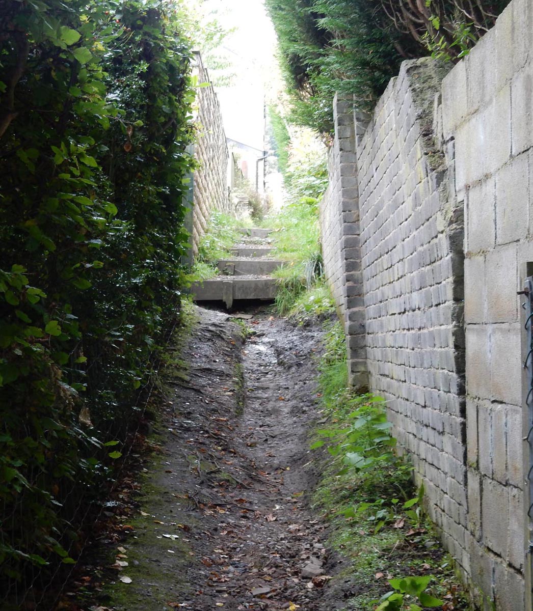
A long stretch of the path runs between Stanleyhall Wood and a field, where the path has a steep crossfall towards a stream hidden in the wood’s undergrowth. Along the path, the original route bore left, down the bank through the thickets , across a now-waterlogged level area to to join FP18.

A long term goal of Evan’s is to restore the lost section of path with wooden steps and a boardwalk. In this project sequence we would remove much of the physically, and visually obstructive vegetation as an exploratory task, but the structural woodwork will have to wait for a future project visit.

Near the canal, FP63 meets a short FP64 which crosses the canal, but this intersection provides the optional route for walkers to turn away from the canal and descend the gentler slope, southwards, onto FP18.

In this project, water from the boggy land, at FP18’s west end, would be drained by digging a new ditch, to discharge water through a new pipe, passing under the path, northwards, towards slightly lower ground by the canal.

FP18 continues NW, negotiating streams and boggy areas, towards the canal.

A stream flowing along the path further west would be culverted at the first meeting point of stream and path. A pair of new pipes would take the stream under the path onto slightly lower ground, canal-side. We would reduce the flooding of the upstream land south of the path and east of the stream by clearing the stream of obstructions, and capturing the overflowing waters where the stream meets the level ground from the higher woodland. A ditch would be dug alongside the path to draw off the surface water and feed it into the stream near the twin-piped culvert where it would pass under the path to the slightly lower ground.

The path heads north-west near the canal through very overgrown and encroaching holly, rhododendron and other shrubs along most of the path. The rhododendrons would, especially, be extensively cut back.

The path follows another stream westwards to Cheshire East’s boundary where it crosses the stream and continues within Stockport’s jurisdiction.

The Team at Work

Vegetation Clearances

ECR Projects Team members assembled at the golf club carpark on 24th March 2015 for the first of five intermittent days work. Several team members concentrated on vegetation clearances – initially on FP63.

At the golfcourse clubhouse a ten metres length of obstructive Leylandii hedge was cut back. This hedge is young enough to re-establish its side shoots further away from the narrow path. Six wood ‘sleeper’ steps were re-set and their surface stapled for grip, as a temporary measure. The steps will require replacement after adjacent building works is complete, or later.

Beyond the golf course, FP 63 heading towards the canal was formed on a steep cross-slope beside very overgrown holly and other trees. These were heavily cut back, by attacking from inside the wood and from the path, to widen the path to 1.5 to 2.0 metres clear width.

To investigate the original route profile linking FPs 63 and 18, smothered by vegetation, the mix of tree branches, brambles, holly and dense undergrowth were substantially cleared. This was aided by a bladed strimmer to expose where the path originally descended the bank to FP 18. A large standing tree and a fallen tree partly blocked the direct line for steps and a boardwalk on the swampy ground below. The remaining clearance and timber structural work might be a future project.

Our team carried out extensive removal of rhododendron and holly along FP 18.

Drainage Works

The current path adequately follows the field fence to FP 64 and its shallower descent cutting back to FP18 below. But the intersection with FP18 is situated by the swampy ground described earlier.

In May 2015, a 250 mm diameter pipe (purchased by ECR) was embedded to carry the flow under the path, with a stone flagging outfall apron, and the pipe’s surround protected by scavenged bricks, boulders and stones. Sedge clumps were built over the inlet and outfall to protect the pipe ends from UV sunlight and footfalls.

Ditches were dug to ‘gather’ the water from the upstream boggy areas. Eleven weeks later the pipe and trenches merged well with the surroundings……

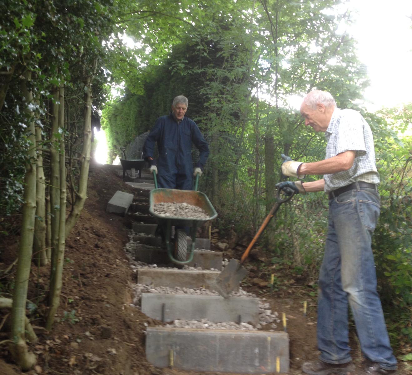
In early January 2016, our team returned to the site, twenty metres further north of the completed first pipe crossing. Here, we gathered to construct a larger capacity piped crossing for the stream crossing the path. The path here is barely above the stream bed and adjacent ground’s somewhat flooded level on both sides. Winter flows are substantial. Therefore a pair of 250mm dia. pipes was adopted for this crossing. The small diameter enables the pipes to be kept above the stream-bed level for full effective water flow. Whereas a single larger diameter pipe would be half-buried below stream-bed level and its lower half would silt up permanently.

The path between the two piped crossing sites is not raised clear of the wet-land south of the path, and is perpetually prone to mud surfacing. To alleviate this, by lowering the water surface, the wet-land’s stream bed was cleared of vegetation and adjacent obstructions on its course to the path over the wet-land margin from as far south as where the woodland rose.

In addition, a new collecting ditch was dug alongside the path and drained into the stream near to it’s twin-pipe culvert.

At a future projects visit, gravel may be imported along the canal towpath to the bridge accommodating FP64. From here, it would be wheelbarrowed 25~50 metres and laid to raise the path above this wet-land section of FP18. And wood steps and a broadwalk may be built up the bank as discussed. There is a ponded area further east, separated by the path from the canal drainage. A pipe would be beneficial across the path here, and the path similarly raised with gravel – in the future.

A discarded finger post was re-set southwest of the club house, with extra disks to indicate several intersecting paths. A finger post, by the carpark start of FP 63, disturbed by neighbouring building works, was reset by Stanley Hall’s new wall.

A Conundrum arises when crossing the twin fairways between the clubhouse and Stanleyhall Wood:……

The path has a twenty degrees change of direction at a point between them, which is indicated on the waymarker post located here, by the arrows on its opposite faces. These are angled to point at 11 and 1 o’clock accordingly. However, the post is regularly removed by a groundsman mowing the fairway, and their disk faces are re-installed either a) correctly, b) at 90 degrees, c) 180 degrees (thereby pointing about-face at 1 and 11 o’clock!), or d) left lying on the ground. The dilemma arises for a walker faced with a) -correct, b) or d) -useless, or c) -completely mis-leading. The paths direction is especially difficult to see coming from the clubhouse. Many walkers feel exposed to criticism if they ‘go astray’ on fairways. So I ‘solved’ the problem by tacking waymarker disks lightly onto a nearby tree, and replaced the disks on the post with new ones orientated at 12 o’clock – as the best compromise.

Our thanks go to team volunteers Helen Battilana*, Mike Bull, Mike Collins, Sue Dale, Roger Fielding, Adrian Flinn, Ken Hobbs, Duncan Learmond, Elizabeth Lees, Frances Moore, Gill* and Tom* North, Steve Osborne, Lynda Shaw, Ian Wasson and myself. The team contributed 124.5 hours of work (excluding lunch breaks) over five site visits on which days 16 persons attended 35 person days. * Sorry – no photos.

~~~~~~~~~~~~~~~~~~~~~~~~~~~~~~~~~~~~~~~~~~~

.

Restoring a Concessionary Footpath at Back Dane, Wincle – ECR Projects Team, November 2018

Back Dane is by the confluence of the River Dane with Clough Brook, just south of Burnt House Farm, Wincle. Wincle footpath 26 follows the rural river valley at a higher elevation.

Map view centred on OS SJ 9699.6629

Alan Catherall is the ECR Footpath Inspector in this parish and whilst there, has expended some of his time and enthusiasm in 2017 by negotiating with the very cooperative land-owner, Mr Francis Goodman, to allow an old Defra-created ‘Conservation Walk’ to be restored as a Concessionary Path.

A faded Defra notice attached to finger posts near each end of the concessionary path

The path, marked in red dashes on the OS map, descends to follow the river at this lovely, secluded location in the valley bottom. It forms a one km. diversion from the higher level PROW path FP 26 between Allmeadows and Bartomley Farm.

Alan sought the resources of ECR and its Projects Team to supply and install the signage for this path, and to clear the route of obstructive vegetation. On an autumnal day in November ’17 Alan and I spent a delightful time walking the proposed concessionary path and planned the locations of five way-marker posts defining the route, and restoration of two finger posts on FP 26 intersections.

Walking the Concessionary Path from the north end, we approached two hairpin bends on a rocky and grassy descending track to the River Dane……

The route follows the river down-stream…..

At the rivers’ confluence, the route climbs to join FP26……

We also walked the higher path FP26 to return to our start, and judged it needed selective vegetation clearance to keep its route clear.

Walking FP26 north to our starting intersection with the concessionary path……

The Tasks

On 6th December 2017, seven ECR Projects Team members arrived at Allmeadows to carry seven heavy posts, post-digging tools, and various tree and shrub clarance tools down to Back Dane and beyond. This day four waymarker posts and one finger post were installed.

Whilst posts were being installed, other team members cleared vegetation on the new path and much of the PROW path between the concessionary path intersections with it. I am sorry not to have photos to include of all our helpers listed, but we were working on parallel paths simultaneously.

Three members returned on the 12th December, installed one finger post and one waymarker post, and continued with clearance works on the concessionary path.

Upper PROW FP 26 work:-

Concessionary path waymarker posts erected and disks added:-

The workers (some of them)! Chris Munslow, Roger Fielding, Mike Collins. Waymarker post at south upper hairpin. (Track turns behind the photographer).

Three of us returned on 12th December to work in snow in minus two degrees Centigrade crisp cold air to finish the post erections and fix waymark disks.

We also cut away some fallen trees and removed gorse clumps.

These days proved very enjoyable and Alan was very satisfied with the result.

Going home – an ethereal view of Allgreave and Midgley Hills’ ridge

ECR Footpaths Project Team members who attended were Janet Allan*, Alan Catherall, Mike Collins, Roger Fielding, Chris Munslow, Gill* and Tom* North, and myself, Brian Richardson. We eight people contributed 12 person-visits providing in excess of 43 hours work excluding lunch breaks etc. * Sorry – no photos.

~~~~~~~~~~~~~~~~~~~~~~~~~~~~~~~~~~~~~~~~~

.

Removing the boggy ground on Rainow FP 14’s intersection with Charles Head Link Path- ECR Projects Team, August 2014

Those of us who have read the notices at either end of the Charles Head concessionary path will note the value of this linking path along the Todd valley watershed (marked CP in mauve on the map) and can thank Alan Catherall and John Goodman for their aptly described patience in gaining the landowners’ permissions for the path.

Map centred on OS SJ 978 775.

Therefore, it was unfortunate that, after descending southwards from the permissive path onto Rainow Footpath 14, it met five metres of sedge-covered and very boggy ground, then a wire-mesh fence with a wooden stile, followed by a further ten metres of sedge and bog before the path followed up a narrow cleft between a fence close by on the east side, and a steep bank on the west side, thence to a stile stepping onto Broad Moss.

The waters, coming from the sedge-covered hillside west of the path, are fed by springs above. Negotiating this area seriously dampened the pleasure of walking this route!

ECR Footpaths Projects Team was asked by our Footpaths Committee to consider if we could improve FP 14 at this location. I said the task was well within the capabilities of our enthusiastic and committed volunteers to complete a scheme. Permissions were given by the land-owners, with the support of CEC PROW Officer, Evan Pedley. Farmer Andrew Maynard gave permission for us to utilise derelict dry stone wall materials nearby. He asked me to ensure a cattle-run across the ravine, below the path, would be restored during the works.

I proposed to dig a trench on the west side of the path, rising southwards along the hillside, to collect the bog water and deliver it to a pipe we would place across the path in the worst boggy area further northwards where the concessionary path was met. The trench would be edged with rocks to protect the path, and the path surfaced in rocks to replace its boggy sedge-vegetated surface, currently flooded by water from the higher hillside to the east. The pipe would outflow into the steep clough below and flow away to the east. A few feet below the pipe outfall, its waters would be collected into another short length of pipe, over which a rock platform would be constructed to enable cattle coming up from Summer Close Farm to cross the clough, below our newly surfaced FP 14, to reach the field beyond.

We commenced work on 1st August 2014, by hand-hauling a six-metre length of 225mm dia. pipe, a galvanised steel gate, two finger posts and a way-marker post, up the steep hill climbing from Summer Close Farm in the valley below.

Considerable time and effort was spent, using mattocks and spades, on the four metres length by two metres width of path between the southerly fence and stile and the northerly intersecting permissive link path, to dig out a foot in depth of thick-stemmed, densely-rooted sedge biomass which inhabited all the water-logged ground over a gritstone base. In rainy weather, water flowed across, unabated from the hillside above. The boggy sedge mass was disposed of by shovelling it eastwards over the edge and into the steep sedge-filled clough beyond. It is worthy of comment that the sedge was extremely tough to cut with spades and was extremely acidic. The metal eyes and lugs of laced leather boots immersed in the bog showed rusting by a day’s end! A channel was dug to take away the water and to bed a four-metre long, 225 mm diameter, pipe diagonally across the path just north of the fence.

Stones recovered from the collapsed walls about the site, and from rock rubble originating as a buried track in the bog, were sorted into stockpiles on what was becoming a very muddy and congested site. The pipe was embedded in a surround of smaller stones to protect it from being punctured and covered with rocks to form the path surface.

At the east end of the pipe, the ground fell away steeply, and we constructed a retaining wall with the largest rocks surrounding the pipe outfall. Some of these large rocks were claimed from collapsed walling by the path 30 metres downhill towards Summer Close and were wheelbarrowed to the retaining wall site, helped by a team member pulling an attached tow rope.

Just south of the stile and fence, a twenty-metre long drainage channel was cut along the west edge of the path through the sedge vegetation and weathered glacial boulderclay bedrock at the base of the hillside. The channel was linked to the downstream pipe by extending the ditch northwards, cutting through the projecting hillside where the fence crossed the path. At the fence a short pipe was laid in the ditch and surrounded with rocks to make it stock-proof under the fence.

Large sumps were dug and lined at both pipe inlets to collect and guide the waters collecting in the channel. The main pipe’s inlet was protected with rocks to divert walkers and deter them from dislodging rocks and debris which might cause blockage.

A low dry-stone ‘wall’ was constructed alongside the trench to support the path’s edge and the path was cleared of sedge and mud and surfaced with selected packed rocks. These rocks were collected by wheelbarrow from the collapsed wall along the path.

When excavating for the main path and the crossing pipe’s bed, the biomass was tipped into the clough. The biomass was subsequently shovelled beyond the cattle-run location to find bedrock underneath upon which to found the lower pipe culvert.

A pipe was laid, embedded and surrounded in rock, and covered in large stones to make the path robust against cattle hooves. A retaining wall and outfall rock apron was formed to support the pipe outlet. An inlet sump was dug and rock lined to collect the outfall water from the upper footpath pipe. It was essential to construct this cattle path to a standard the farmer would consider satisfactory, in view of his cooperation in allowing us to construct the paths using his collapsing dry stone walling rocks.

A stile entering the path from the east, which allowed some waterlogged bog and sedge to be by-passed, was dismantled. The top barbed-wire strand along the path-side fence was disconnected from the fence posts, lifted to the more remote field-side of the fence and re-stapled in place. This was an essential safety measure, because the path is situated in a deep Vee notch, tight against the fence as it climbs up southwards to Broad Moss.

The drainage trench collecting hillside seepage was extended more shallowly high up this Vee path, to divert water from running down the lower path surface.

At one location, stonework was placed to divert the trench into the more substantial channel below, and three stone steps were built beside it; for which specially selected, very large flat stones were taken from the wall debris northwards and collected with a wheelbarrow as described above.

Two finger posts were placed on Broad Moss and a way-marker post placed at the top of the gully to direct walkers navigating the southern approach to the correct path. Projecting staples were embedded in the top stile’s two steps as an anti-slip measure.

Gateposts were erected, the new galvanised steel gate was hung, and the fencing was linked permanently over the new piped segment of the new ditch. An essential spring closure mechanism was added as a finishing touch to the gate later in September.

Mike Collins’ photos taken after very wet weather a year or so later show the effectiveness of the project. Thanks Mike.

I would like to thank all ECR Projects Team participants for their tremendous support and strenuous work in mixed (some very wet) weather. This work was carried out by Mike Bull, Alan Catherall, Mike collins, Susan Dale, Andy Davies, Roger Fielding, Barbara Hare, Ken Hobbs, Gill and Tom North, Steve Osborne, Brian Richardson and Ian Wasson. In summary, 13 Project Team members made 44 day-attendances between them, actively working (breaks excluded) 219.5 hours, spread over 11 attendance days; attending on average as four volunteers per day.

.

THE WORK OF THE EAST CHESHIRE RAMBLERS FOOTPATHS COMMITTEE

East Cheshire Ramblers ensure their footpaths are in good orderThe East Cheshire Group of the Ramblers is active in checking and inspecting the network of Public Rights of Way which exist across the splendid countryside in East Cheshire. There is a legal duty on the highway authority and on landowners to ensure that public footpaths are maintained in a walkable condition.

If you find a path in East Cheshire that is obstructed or want to report a fault to the Council go to the public rights of way page of the Cheshire East council web site – https://www.cheshireeast.gov.uk/leisure,_culture_and_tourism/public_rights_of_way/public_rights_of_way.aspx – where you will find a link to an online problem report form.

If, after submitting this form, you do not get a satisfactory response, please report the problem to us using the link at the end of this article and we will follow it up.

East Cheshire Ramblers cover an area of 33 parishes from Poynton in the north to Wincle in the south and, east to west, from Chelford to Rainow.  There are over 1270 paths which criss-cross the area and every path is surveyed annually by our volunteer inspectors. By far the majority of paths  are in good order, thanks to the co-operation of the landowners and the tireless work of Cheshire East Council Public Rights of Way (PROW) Unit.  Sometimes a path can be obstructed by a fallen tree, a newly erected fence or sometimes a stile or gate is damaged. Our inspectors report these faults to the PROW Unit who ensure the fault is rectified promptly.  Some inspectors also fix yellow waymarking signs to ensure walkers can keep to the correct line of the path. To cover such a large area, over 40 of our members are inspectors and we are always on the lookout for more volunteers.

In addition, we have a group of volunteers who undertake more practical tasks such as cutting back vegetation, repairing stiles and improving the path surfaces.

How is all this co-ordinated? Well, since 1986 East Cheshire Ramblers have organised a Footpaths Committee who meet regularly to discuss the latest problems and the progress with the annual path inspections. At this forum proposals for the legal diversion of the rights of way are debated and comments made to Cheshire East Council. We look after the interests of all walkers and we will not agree to any proposal that significantly reduces the enjoyment of the path.  If necessary, but rarely, we will make a formal objection and argue our case at a Public Inquiry. In such cases we are able to draw on the legal expertise of the Ramblers Central Office in London. If you enjoy walking, please join the Ramblers organisation and help to support this vital work.

Here are some photographs to illustrate the group’s work


The footpath goes under the bridge. This obstruction was reported by our footpaths inspector and Cheshire East Council ensured it was removed.

The footpath goes under the bridge. This obstruction was reported by our footpaths inspector and Cheshire East Council ensured it was removed.
A memorial bench was installed some years ago by the East Cheshire Ramblers Group on the Ladybrook Valley Interest Trail in Poynton. Rest a While!

A memorial bench was installed some years ago by the East Cheshire Ramblers Group on the Ladybrook Valley Interest Trail in Poynton. Rest a While!
The path has been eroded by the stream over a number of years. A temporary diversion of the footpath has been implemented.

The path has been eroded by the stream over a number of years. A temporary diversion of the footpath has been implemented.
A fallen tree is blocking the footpath beyond the kissing gate. It is the responsibility of the landowner to remove the obstruction, but if they do not act then Cheshire East Council can remove the obstruction and charge the cost to the landowner.

A fallen tree is blocking the footpath beyond the kissing gate. It is the responsibility of the landowner to remove the obstruction, but if they do not act then Cheshire East Council can remove the obstruction and charge the cost to the landowner.
This has now been replaced by a kissing gate.

This has now been replaced by a kissing gate.
Our footpaths inspector reported this problem and it was dealt with promptly by Cheshire East Council.

Our footpaths inspector reported this problem and it was dealt with promptly by Cheshire East Council.

Here are some links which will be useful to obtain further information on footpaths and rambling in our area

Neil Collie


Reconstruction of Footpath 22 at Bollington by ECR Volunteers

Before we started

Before we started

After we finished

After we finished

Sometime before October 2015 Evan Pedley of PROW, Crewe, asked me if our project team would repair a flight of wooden steps on Bollington FP22, which climbs from Ingersley Road up to Shrigley Rise. This seemed feasible at the time, because we could collect new wood for the steps as a contribution by PROW Department from its depot at Winsford; and Bollington Town Council would contribute up to £500 (plus VAT) towards materials.

The path climbed over fourteen metres in height over a length of 69 metres from its start in the field below a bottom kissing gate. The path was a surface drain for regular rain run-off from the impermeable surfacing of Shrigley Fold, and even off the main Shrigley Road in heavy rains, at the top of the path. It formed a deep gulch (a word chosen conservatively) and walkers were required to straddle the hollow and walk the haunches when the surface was wet and slippery. It held twenty-four rotting wooden steps.

Evan requested that precast concrete (p.c.) highway kerbs are deployed to resist the waters and to provide more durability than wood on this frequently used urban path. The prospect of me asking a voluntary project team of predominantly senior citizens who, with respect, are past their prime, to manoeuvre 70+ kg kerbs for 60 metres along the path, and up to 14 metres down the steps, was daunting. So, despite spending time on several occasions surveying the existing eroded wooden steps with my family’s help, I deferred the work to a future suitable period. Gradually, a sense of obligation took control and triggered me to allocate June through August this year, pending team support, to ‘fit’ the steps into the diary.

dscn0145

Ken in an overgrown section of the path before work started

dscn5681

Rainwater run off had undermined the path

Shrigley Rise neighbours have been very accepting of our disruption, allowing me to park as many as four bulk bags of gravel and two pallets of kerbstones on their private driveways on several deliveries, and special thanks go to Siobhan and Max for allowing us to store large tools and two wheelbarrows in their rear garden, Sarah for passing Ice cold drinks through the hedge and Rob for his oil for the wheelbarrows! Additionally, the team was given enthusiastic encouragement by path users.

To create a safe and durable working/walking space, we started by clearing vegetation, predominantly of naturally established, but badly located, trees and branches. We next repaired two wooden steps and added a third step in the field approach from Ingersley Road, below a bottom kissing gate. Higher up, two existing p.c. highway kerb steps were relocated, and the 24 existing wood steps were replaced by 47 new p.c. bull-nosed (rounded top corner) highway kerbs. Some steps were constructed full width of the space between walls to reduce erosion. We have placed twice as many steps (52 instead of 28) and a more even gradient between step rises in our construction. There are important benefits in that both of the latter measures dissipate the energy in rainwater flows down the path and steps and minimise erosion; and the threshold of difficulty for locals in scaling the steps has been considerably reduced,

We commenced step building, by progressively removing old steps, excavating for the new ones, placing them to line and level, and constraining their facing lower edge by steel pins. For safe working we spread ourselves in pairs up the path, but inevitably found coordination and cooperation between the teams was essential to enable materials to be moved across each of the work fronts. As the workdays passed, the shape of the stairflights crystalised, and a bulge in the slope was reduced by excavating for, and lowering, some steps. The bulk of our fill material is 40mm sized limestone aggregate, which allows water to pass in a restrained manner, but is firmly positioned. A surface skim of 14mm limestone chips is gentle underfoot and knits the surface together.

img_0666

Ian tipping a barrow load of limestone chippings as Nick is poised to spread them out

dscn0183

Mike and Alan at work. Kerbs ready to be laid on the right

Several thoughts disturbed my sleep prior to starting on site: I dreaded finding we could not drive 16mm dia. steel pins 400mm into the underlying ground, to hold the kerbs in place, due to being rebutted by solid rock here and there. Such rebuttals occurred only once or twice. I was majorly concerned about moving the 70+ kg kerb units along the path and down the steps. I purchased a two-wheeled bag trolley to park them next to their final resting place, and two proprietary lifting tongs for multiple lifting to place them on a trolley and at each temporary and final accurately allocated placement. My overall concern, of course, was whether sufficient team support members would declare themselves willing to carry out this very heavy labour. But, as always, a team performed on each day.

We completed the project on 9th August. On which occasion two walking groups of eight and twelve persons coincidentally chose to pass respectively up and down the path!

Between two and six team members have attended on seventeen occasions between 26th June and 9th August, (generating 62 volunteer-attendance days) and served 296 man-hours of labour (excluding lunch breaks). During this project, 13.5 tonnes of limestone have been shovelled, and accepting that each pc concrete kerbstone has been lifted and transported twice, 8 tonnes of pc concrete has been lifted and placed. Also, a large amount of soil has been dug, moved and reprofiled during the scheme.

ECR Group have purchased £1792 (Vat Incl.) of materials, and Bollington Town Council have contributed £558 (Vat incl.) of that total.

dscn9673

The bottom end of the path as completed

For the success of this project, my thanks go to Janet Allen, David Bates, Helen Battilana, Ian Black, Nick Brearley, Mike Collins, Roger Fielding, Adrian Flinn, Barbara Hare, Ken Hobbs, Philip Hodgkinson, David James, Roger Jubb, Gillian and Tom North, Ian Wasson, Nick Wild, Alan Wilson, my wife Helen and son Damian (as surveying assistants).

Brian Richardson

Some of the team

Some of the team – Adrian, Mike, Ken and Roger

ECR 2015 Footpath Survey Results

This is a summary report on the footpaths with the ECR area.
The basis of the report is from the inspections made by our Footpath Inspector’s, using the footpath status A to D.

There are two themes to the report;

Firstly an overview of footpath status from 2009 to 2015 indicating 89.4% of footpaths in the 2015 survey were classified A and B which is Good/Acceptable. This is consistent with previous years.

Secondly, the number of paths in the Class D (Obstructed), through the years of 2012 to 2015, with the objective of showing those paths that continue in Class D.

Footpath Committee

DB Summary of 2015 Results