WALKERS – EVER WONDER WHAT GOES ON DOWN BELOW ?

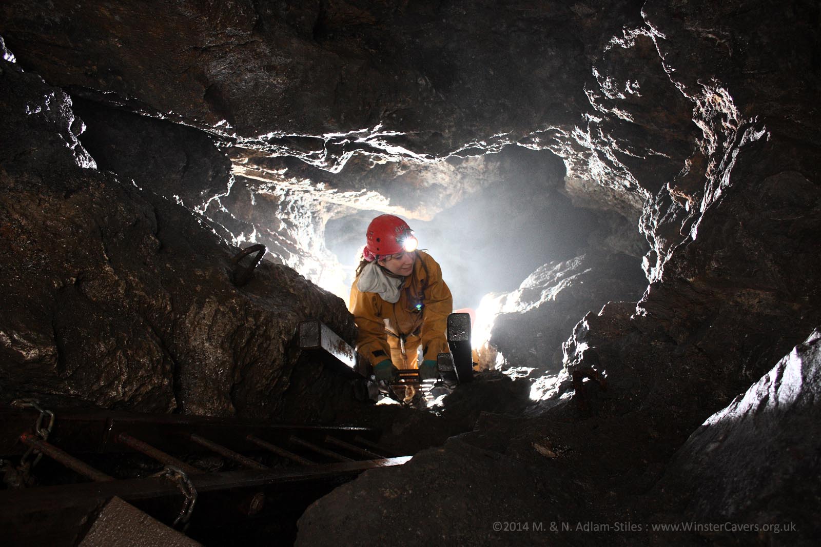
A typical scene underground. It’s not one of us – a photo provided by Winster Caving Club

Walkers regularly come across long-abandoned mines on outings to the Peak District but rarely do they get the chance to find out what is happening beneath their boots underground.

Just such an opportunity occurred recently when a 21-strong party of intrepid East Cheshire ramblers visited Ecton Hill in Staffordshire between Leek and Buxton, once home to Europe’s largest and richest copper mine.

With a mining history dating back 3,500 years, the slopes of the towering, grass-covered hillside conceal a chequered past under a succession of owners, several of whom made their fortunes and others who went bust.

By 1790, after Ecton had been acquired by the fifth Duke of Devonshire, 400 workers – men, women and children – toiled beneath the surface, often in appalling conditions and living with the constant threat of flooding or an explosion.

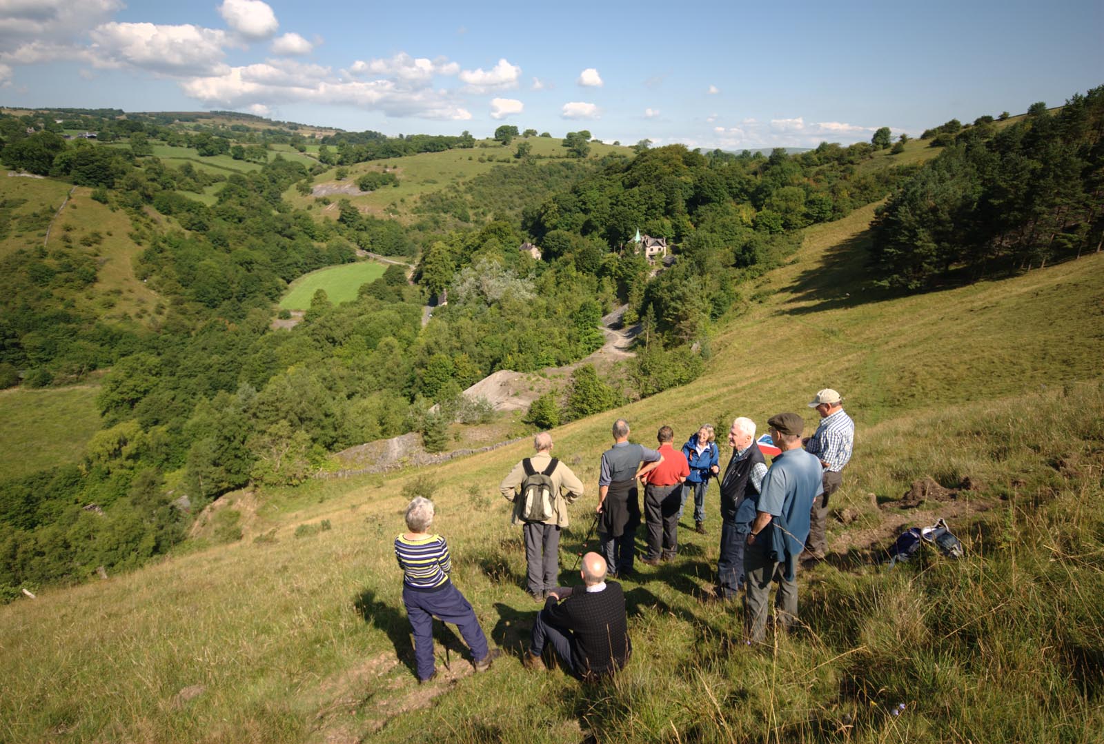
The party during their tour of the surface workings on Ecton Hill

During its heyday in the 1800s, it is said that the Duke made sufficient money to build the magnificent Crescent in Buxton, producing around 100,000 tonnes of mainly copper ore (but also lead) and made a profit of £300,000, equivalent today to a jaw-dropping £24.4m.

Much of the copper was used to make brass and was also rolled into copper sheets for the Royal Navy to protect ships’ hulls against boring worms.

Ecton finally closed in 1891 having been at the forefront of mining technology. Indeed, many famous scientists and engineers of the day had links to the mine : James Watt and Matthew Boulton supplied its steam engine, whilst James Banks discovered new life forms in the cavernous depths down below.

East Cheshire Ramblers’ tour was arranged by leader Brian Griffiths courtesy of the Ecton Mine Educational Trust which operates regular visits and field studies for organised groups. For further information go to www.ectonhillfsa.org.uk.

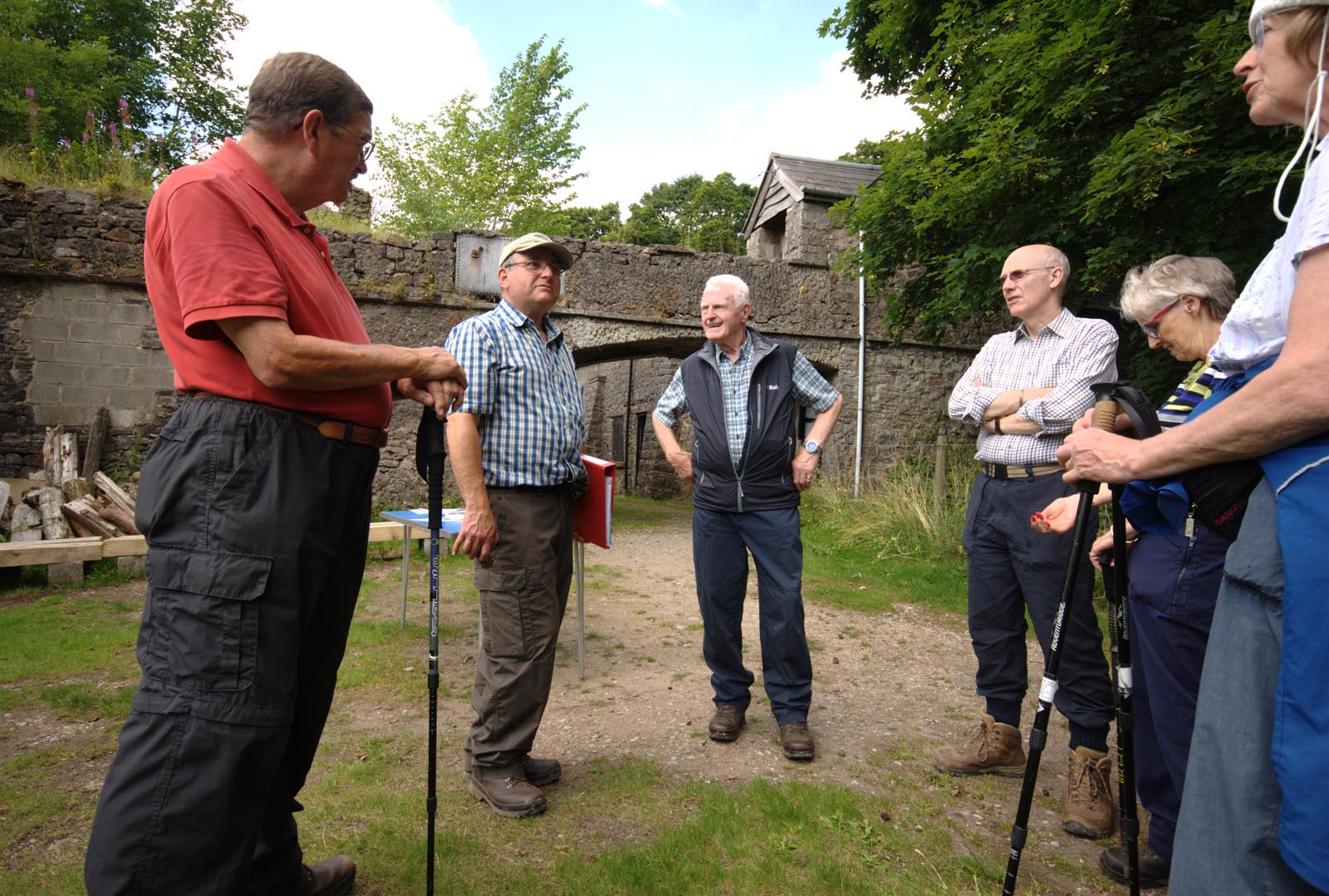
Our guide answering questions outside the mine’s visitor centre

Linda and Gwen’s End to End Walk

Made it ! Linda Brackenbury (left) and Gwen Sproston at the end of their epic walk.

Made it ! Linda Brackenbury (left) and Gwen Sproston at the end of their epic walk.

At a time in life when many women of their age would be content to spend their days pottering in the garden or knitting jumpers for their grandchildren, pensioners Linda Brackenbury and Gwen Sproston decided to walk from Land’s End to John O’Groats.

But instead of simply following the usual route based on roads and well waymarked national trails, they plotted a more direct walk using public footpaths and bridleways as much as possible – and in the process managed to carve nearly 200 miles off the 1,200-mile trek.

Now Linda (age 67) from Cheadle Hulme, Cheshire, a retired University of Manchester lecturer in Computer Science, has published a 371 page book of their 1,035-mile, end-to-end journey. Hence the title : Walking e2e.

Between them, Linda and Gwen have nine grandchildren. Their epic feat took just 71 days between April and June 2012 and included a staggering 101,000 ft (31,077 metres) of ascent with only three days rest along the way and two days of travelling either side.

Covering an average 14½ miles daily, the 71 sections ranged from 6 miles to a maximum of 21 miles. Each stage is fully described and illustrated with sketch maps to make it easier for others who want to follow in their footsteps. There is also helpful advice on transport and accommodation.

“Thanks to Gwen’s superb navigation, we hardly put a foot wrong,” said Linda, who explained that they wanted to avoid the better-known, national trails because these often meander into popular tourist areas and generally attract more people.

“In fact, we stuck to quiet, public footpaths as much as possible as well as old drovers’ trails and military roads. As a result, we only saw 41 other walkers throughout our journey and many of these were friends and relatives who came to cheer us on along the way.” These included ten members of their walking group, East Cheshire Ramblers, who spent a day walking with them from Barnton to Glazebrook, Cheshire.

So would they do it again ? “Like a shot,” said Linda immediately. “Both of us felt a terrible sense of anti-climax when we got to John O’Groats.”

Apart from acting as navigator, Gwen (age 69), from Chelford, Cheshire, chronicled their feat in more than than 1,500 photographs, which are used for talks to raise money for local charities together with the proceeds from book sales.

Copies of Linda’s book, Walking e2e, can be ordered price £15, inc p.p., via her website : www.brackwalks.co.uk. ISBN 978-0-9931833-0-0.

Linda Brackenbury signs copies of her book Walking e2e

Linda Brackenbury signs copies of her book Walking e2e accompanied by fellow members of East Cheshire Ramblers

Our Press Publicity Is Under Threat

Roger’s article in the Manchester Weekly News on July 2nd

This is an example of the free publicity we have been getting through articles submitted to local papers by Roger Norton, our press officer.  We have a weekly spot in the Macclesfield Express and regular articles in the South Manchester editions of the Manchester Weekly News.

But Roger has run out of articles so, if you have led a walk recently or been on one that you have enjoyed,  send Roger a few paragraphs about it to keep the publicity going.

A Walk to Remember

Marie Curie are hosting a “Walk to Remember”, a 10k twilight walk in Tatton Park at 6.30pm on Saturday 8 August 2015.
The walk is open to walkers and dogs of all ages and abilities.
The aim of the walk is to remember someone special and to raise funds for Marie Curie, a charity that assists local people living with terminal illness.
The walk will be followed by entertainment and fireworks.
Read about it at mariecurie.org.uk/walktoremember

FOUR VILLAGES AND A HAMLET – A WALK IN THE WHITE PEAK

John in conversation with Brian during the climb to Longstone Edge

The ‘plague village’ of Eyam in Derbyshire was the starting point of a recent 12-mile circular walk by East Cheshire Ramblers.

Eyam is best known for an outbreak of bubonic plague in 1665 when the brave villagers chose to isolate themselves rather than flee in order to prevent the disease from spreading.

As well as numerous graves and moument that can be seen among its quaint stone-built cottages, the ten walkers passed one of several boundary stones around the village where incoming food and supplies were exchanged for coins saturated in vinegar.

With perfect timing, light drizle just before the start soon gave way to sunshine (causing walk leader John Goodman to utter some words about sunshine and the righteous) and indeed, the weather remained fine, if a little gusty, all day.

In Stoney Middleton the group noted the early 19th century octagonal toll bar house, now a thriving fish and chip shop.

Coffee overlooking the wooded Coombs Dale was followed by an ascent to Longstone Edge and its outstanding views. Formerly a productive mining and quarrying area, the Edge has now been widely reclaimed by nature.

The next objective was the attractive village of Great Longstone, which was approached through colourful meadows. Appropriately, on a Test match day, lunch was taken on benches at the village cricket ground, again with extensive views.

The fourth and final village of Little Longstone was the next objective, before the party headed up to Longstone Moor, and a wind-assisted return to Eyam via the hamlet of Housley.

As well as various places of historical interest, including a pre-historic ‘double dyke’, the group also spotted a rare bee orchid in full bloom.

A bright and breezy day on Longstone Edge

John Goodman

Rambling in the Dane Valley

Pausing for a group photo on the lane towards Hanging Stone

Our walk on April 18th started at Danebridge, from where the party of eleven walkers set off in glorious sunshine to the Ship Inn, then following a footpath passed Wincle Grange, towards Dumkins. High overhead, we spotted two buzzards circling effortlessly.

As we gained height, we enjoyed spectacular views, with the countryside opening up all around. Rolling hillsides were revealed, covered in many shades of fresh green vegetation, all lit up in the bright Spring sunshine.

We descended to Whitelees Farm and had morning coffee break beside the River Dane, glimpsing the occasional yellow flash of busy grey wagtails.

Our route ascended from the valley once more, passing Bearda Mill, with its old water wheel visible from the road. As we crested the hill we were surprised to see a bust of Karl Marx staring down at us from an open barn window.

The dramatic Hanging Stone was our next waypoint, and on the descent through woodland our party was amazed to come upon a group of kilted Scottish warriors, en-route to battle, complete with faces painted – Braveheart style – with blue woad.

The Warriors

We crossed the River Dane once more to pass the former Youth Hotel at Gradbach, shortly before lunch. The afternoon saw us visit the picturesque Three Shires Head, where the boundaries of Cheshire, Staffordshire and Derbyshire meet, before traversing the moorlands leading to Wildboarclough.

After another waterside coffeebreak we crossed Hammerton Moss before returning via Wincle to the start point, having covered a total of 13 miles.

Michael Murphy

Outside the Ship Inn at the end of the walk contrasted with a photo taken around 1935


The Ramblers Go Bowling

The Ramblers bowling group taking a break outside the clubhouse

On Sunday 26 April East Cheshire Ramblers visited Macclesfield Bowling club for a  crown green coaching session.

Macclesfield Bowling Green is a quiet oasis in the heart of the town next door to the General Hospital.
The ramblers keen to explore new activities have recently tried gliding and today was the turn of a party of eleven to discover the intricies and skill of the bowling green.
Awaiting the Ramblers were four British crown green coaches who are attached to MBC.
Most ramblers had never been on a  green before and were given a one hour tuition session followed by a competitive games.
Fortunately the weather was perfect for the occasion and most discovered that the sport was more difficult than it looked.  Tea and biscuits gave the group  discussion time  on what the club had to offer.   As well as eleven league teams MBC holds many Open Competitions and social bowling is also very popular.
Chris Munslow

The Flora and Ecology of the Peak District

There will be a talk of interest to all lovers of the countryside at The Wilmslow Gardening Club next Monday, March 16th. The subject is ‘The Flora and Ecology of the Peak District’ and it will be given by Steve Furness of the Alpine Nursery in Calver.  The meeting starts at 7.45 pm at Wilmslow Preparatory School on Grove Avenue, Wilmslow.  Visitors £4 each.

The Three Highest Peaks in Cheshire

On Whetstone Ridge

In spite of the forecast of a very windy day, seven members of the Ramblers met at Clough House Farm car park to face the challenge of climbing the three highest peaks in Cheshire. Their route started along Cumberland Brook and on towards Three Shires Head. Crossing over the packhorse bridge, the group headed over rough moorland to join the Dane Valley Way and the made their way over uneven stepping stones across the swift flowing River Dane. After sheltering for a brief stop in the now abandoned Danebower sandstone quarries, they headed into the bitterly cold gale force winds across Danebower Hollow and ascended over tussocks of grass and heather to the first summit being Whetstone Ridge at 547m (1795 feet).

Crossing the River Dane


Hurrying across the A537 at the Cat and Fiddle Inn, the next target was Shining Tor, the highest peak in Cheshire at 559m (1834 feet). By this time the wind seemed even stronger and, combined with snow and ice under foot, made the ascent quite a battle. Little time was spent admiring the view from the summit. Dropping down across the rough track over Chest Hollow the route progressively descended before climbing again to reach Macclesfield Forest and some welcome shelter. Leaving the trees behind, the windswept steep sided summit of Shutlingsloe, sometimes called ‘the Matterhorn of the Peak’, at 506m (1660 feet) lay ahead. The group was greeted on the top with glorious views in the late afternoon sunshine, pausing awhile in spite of the unrelenting bitter wind. Finally it was back down to reach the car park after a memorable winter’s day in the hills.

Roger Thompson

On Shutlingsloe – the final summit of the walk