
United Utilities, the owners of Macclesfield Forest, have closed the forest to visitors while their staff make safe the large number of trees which were blown over by the recent high winds. More information can be found at https://www.unitedutilities.com/help-and-support/about-us/recreation-sites/
Author Archives: admin
A week in Devon 3-8th September
 This five day break was very different to the Ramblers’ normal trip away and thus I was concerned as to whether it would work well or be fraught with difficulties. I can say that it worked well and everybody seemed to enjoy it. Can I just say that this was the nicest group I have ever had the pleasure of being involved with.
Six of us went down a day early to reccie our walks and did eventually manage to stay in the Manor House, no mean feat. On the Sunday the weather was atrocious and did not bode well for the rest of the week. John Handley had to buy an extra layer before he even set off!! I have to say there is no way, under normal circumstances, I would have gone out in that weather. We returned with everything soaked and we hadn’t even started the trip. We did have a good evening meal and chat which made it all worthwhile.
We walked on Monday, Tuesday and Thursday with Wednesday off to either visit the area or take part in the wide variety of activities. Golf and tennis were taken up by a number of the group.
Evening activities hey, when I discussed this idea with Frank we decided that nobody would be interested but we booked 10 pin bowling on the first night, just in case. Almost everybody turned up and really enjoyed themselves with Dave Gibson being the winner. The second night Ruth organised a fun table tennis tournament and again it was a great success. Frank being the winner, perhaps due to many years being spent in the youth club. The third night we were tutored in short mat bowling by Chris and Sue Munslow and again had a fun evening. The final evening there were several things on offer, including a 60/70 night which several people took part in. So not your normal ECR trip!!
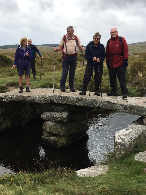
Frank and I led the Meldon Quarry circuit on the Monday described as “a stunning walk, taking in fantastic moorland fringe scenery with views of the high moors and passing under the striking Meldon Viaduct”.
Monday’s other walk was led by Martin who is a walk leader at the hotel, and we started our walk from ‘The Warren’ pub close to Postbridge . Martin was a mine of information (pun not intended) as he told us about the history of mining in the area and of medieval and earlier remains. We looked at areas where miners would stay over the summer and saw where they would have grown vegetables and where they would have had rabbit warrens (hence the name of the pub) to supply meat on site. The moor was beautiful providing a splendid air of isolation and moody rolling views.
A short walk was also led with by a leader from the centre. The weather was kind to us and everybody seemed to have had a good day when we met for dinner.
Tuesday’s long walk was led by Lyn, another walk leader from the hotel, and we started from Belstone. We did an 11 mile tour of the Tors (pun intended) including Hounds Tor, connected to the famous Sherlock Holmes mystery ‘Hound of the Baskervilles’. There was lots of climbing and we had constant rain in the morning, adding up to a tough walk. However, we did not let it dampen our spirits and really enjoyed the 7 tors we climbed, and the views of Dartmoor when we did finally get them in the afternoon.
Laura Hall

Epiphytes in Wistmans Wood
On Tuesday John Handley led a walk to Wistmans wood. What an experience; see his description below. A short walk was also led from the hotel.
This ‘ecological ramble’ began beside a quarry which revealed the granite architecture of Dartmoor. From here we walked along a rough track into the moor. Beside the track gorse had been burnt to provide a flush of mineral nutrients for the sheep. We reflected on a Welsh saying – ‘Bronze under heather, silver under gorse and gold under bracken’.
Next came Crockern Tor, the open-air meeting place of the Stannary Parliament where Devonshire tin mining was adjudicated from the 14th to the 18th century, and where Sir Walter Raleigh himself presided on October 27th, 1600.
From here we followed a ridge, each tor more impressive than the last. Less impressive for the sheep. Up here, where the rainfall exceeds 2,000 mm, the growing season for grass is only 175 days compared to 300 days on Devon’s south coast.
 Hence the tree line in western Britain is depressed and Wistman’s Wood at around 400m is one of the highest oak woods in England. It is a vestige of the wildwood that clothed Britain in early prehistoric times. The ancient gnarled oak trees have survived because the granite boulders between which they grow, known as ‘clatter’, are impenetrable to grazing animals – and not much better for ramblers! They are festooned with lichens and ferns and this is a truly atmospheric place.
After lunch we followed the Cowslic River to join the Devonport Leat. This beautifully engineered channel was constructed in the 1790s to carry drinking water to the expanding Plymouth dockyards. The leat brought us to the edge of the West Dart valley from where we looked down on Crockern farm. The landscape was grey and drab except for a bright green field beside the farm where animals had been regularly folded. We then looked at the grass beneath our feet and saw that it too was a healthy green and full of herbs. We were standing in a medieval enclosure where the ecological memory went back at least 500 years. Dartmoor may be a forbidding place but its landscape history is something to behold.
John Handley
On Thursday 7th September the walk started in the village of Gidleigh. The focal point of the village is the Holy Trinity Church which dates from the late 15th century and nearby are the remains of Gidleigh Castle which is a much earlier building.
From the village the route took us southwards through the densely forested area of Gidleigh Tor to cross the cascading Teign River. The path joined the Two Moors Way leading us through flowering pasture meadows of the lower slopes of Dartmoor.
At French Beer we left the path walking up on the moorlands and shortly reached the remains of Bronze Age hut circles.
Crossing the valley we climbed the slopes up to Thornworthy Tor. Dartmoor is covered with numerous Tors which are the remains of the granite plugs from volcanic activity nearly 30 million years ago. This high point gave us views of the moors and low lying land all round with Thornworthy Reservoir below.
Lunch was at another Tor, Kestor Rock. We sheltered from the prevailing wind surrounded by unconcerned Dartmoor ponies and their foals.
We headed again for distant slopes towards the ‘Long Stone’, three metres tall with initials carved into one face having a more modern use as a boundary stone.

We were now on Shovel Down which has an impressive range of remains dating from the Bronze Age including field systems, stone rows, stone huts, a cairn and the standing stone.
We hadn’t seen stone rows before so they were of special interest to us, being made up of stones which run about a metre apart roughly in a north south direction for a length of up to 180 metres including a Y shape where two rows meet. These may have had a ceremonial purpose.
We continued to walk along the stone rows towards an ancient Clapper Bridge then climbing to a higher point where we came across the impressive Scorhill Circle, before returning to Gidleigh.
Sue Munslow
And the rest of our time????
Diana Beech, in writing about the activities available, said:
The activities enjoyed by the “Gay” group included: archery, tennis (indoor and outdoor), long and short mat bowling, ten-pin bowling, table tennis, swimming, golf, adventure golf, dancing at a 60s/70s night and relaxing in the hydro spa.

Table tennis and bowling brought out the competitive side of many ramblers, creating much amusement for all. The swimming pools and hydro spa provided welcome relaxation after the walks.
Two members of the group didn’t walk but took part in crafts during the day. They sampled enamelling, patchwork and creative embroidery and really enjoyed them, paying about £3 each session for materials used. Pauline tried jewellery making and now is the proud owner of a necklace.
.
This just leaves me to thank Sue and Chris Munslow and John Handley for leading walks as well as Martin and Lynn from the centre. Frank for his support throughout the planning stage and during the week. Also thanks to Louise for the amazing cream tea. Most of all thanks to all who attended for making it such a pleasurable experience.
Jane Gay
Reconstruction of Footpath 22 at Bollington by ECR Volunteers

Before we started

After we finished
Sometime before October 2015 Evan Pedley of PROW, Crewe, asked me if our project team would repair a flight of wooden steps on Bollington FP22, which climbs from Ingersley Road up to Shrigley Rise. This seemed feasible at the time, because we could collect new wood for the steps as a contribution by PROW Department from its depot at Winsford; and Bollington Town Council would contribute up to £500 (plus VAT) towards materials.
The path climbed over fourteen metres in height over a length of 69 metres from its start in the field below a bottom kissing gate. The path was a surface drain for regular rain run-off from the impermeable surfacing of Shrigley Fold, and even off the main Shrigley Road in heavy rains, at the top of the path. It formed a deep gulch (a word chosen conservatively) and walkers were required to straddle the hollow and walk the haunches when the surface was wet and slippery. It held twenty-four rotting wooden steps.
Evan requested that precast concrete (p.c.) highway kerbs are deployed to resist the waters and to provide more durability than wood on this frequently used urban path. The prospect of me asking a voluntary project team of predominantly senior citizens who, with respect, are past their prime, to manoeuvre 70+ kg kerbs for 60 metres along the path, and up to 14 metres down the steps, was daunting. So, despite spending time on several occasions surveying the existing eroded wooden steps with my family’s help, I deferred the work to a future suitable period. Gradually, a sense of obligation took control and triggered me to allocate June through August this year, pending team support, to ‘fit’ the steps into the diary.

Ken in an overgrown section of the path before work started
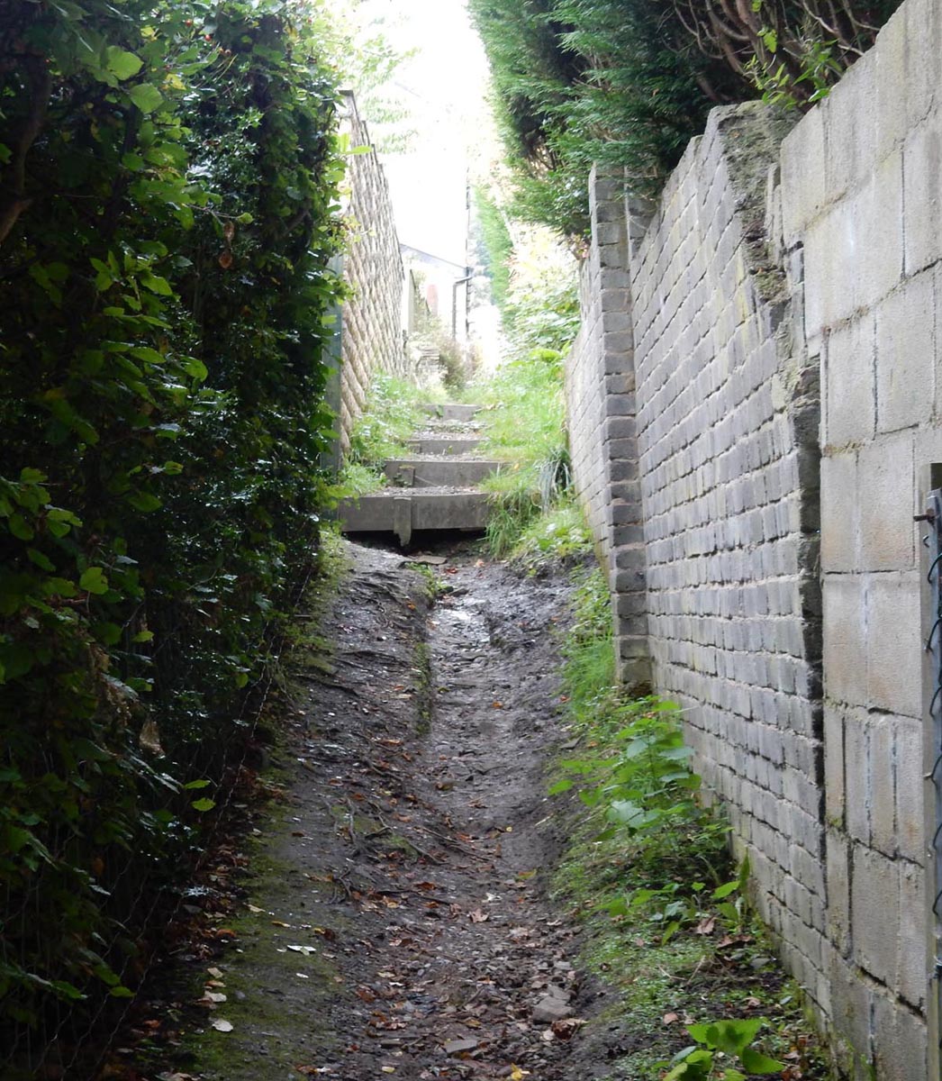
Rainwater run off had undermined the path
Shrigley Rise neighbours have been very accepting of our disruption, allowing me to park as many as four bulk bags of gravel and two pallets of kerbstones on their private driveways on several deliveries, and special thanks go to Siobhan and Max for allowing us to store large tools and two wheelbarrows in their rear garden, Sarah for passing Ice cold drinks through the hedge and Rob for his oil for the wheelbarrows! Additionally, the team was given enthusiastic encouragement by path users.
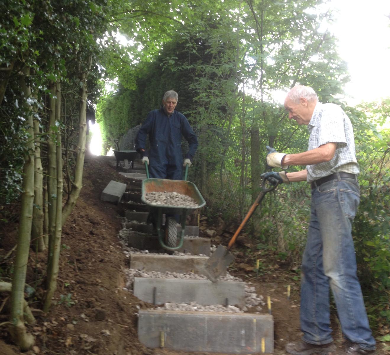
To create a safe and durable working/walking space, we started by clearing vegetation, predominantly of naturally established, but badly located, trees and branches. We next repaired two wooden steps and added a third step in the field approach from Ingersley Road, below a bottom kissing gate. Higher up, two existing p.c. highway kerb steps were relocated, and the 24 existing wood steps were replaced by 47 new p.c. bull-nosed (rounded top corner) highway kerbs. Some steps were constructed full width of the space between walls to reduce erosion. We have placed twice as many steps (52 instead of 28) and a more even gradient between step rises in our construction. There are important benefits in that both of the latter measures dissipate the energy in rainwater flows down the path and steps and minimise erosion; and the threshold of difficulty for locals in scaling the steps has been considerably reduced,
We commenced step building, by progressively removing old steps, excavating for the new ones, placing them to line and level, and constraining their facing lower edge by steel pins. For safe working we spread ourselves in pairs up the path, but inevitably found coordination and cooperation between the teams was essential to enable materials to be moved across each of the work fronts. As the workdays passed, the shape of the stairflights crystalised, and a bulge in the slope was reduced by excavating for, and lowering, some steps. The bulk of our fill material is 40mm sized limestone aggregate, which allows water to pass in a restrained manner, but is firmly positioned. A surface skim of 14mm limestone chips is gentle underfoot and knits the surface together.
Ian tipping a barrow load of limestone chippings as Nick is poised to spread them out

Mike and Alan at work. Kerbs ready to be laid on the right
Several thoughts disturbed my sleep prior to starting on site: I dreaded finding we could not drive 16mm dia. steel pins 400mm into the underlying ground, to hold the kerbs in place, due to being rebutted by solid rock here and there. Such rebuttals occurred only once or twice. I was majorly concerned about moving the 70+ kg kerb units along the path and down the steps. I purchased a two-wheeled bag trolley to park them next to their final resting place, and two proprietary lifting tongs for multiple lifting to place them on a trolley and at each temporary and final accurately allocated placement. My overall concern, of course, was whether sufficient team support members would declare themselves willing to carry out this very heavy labour. But, as always, a team performed on each day.
We completed the project on 9th August. On which occasion two walking groups of eight and twelve persons coincidentally chose to pass respectively up and down the path!
Between two and six team members have attended on seventeen occasions between 26th June and 9th August, (generating 62 volunteer-attendance days) and served 296 man-hours of labour (excluding lunch breaks). During this project, 13.5 tonnes of limestone have been shovelled, and accepting that each pc concrete kerbstone has been lifted and transported twice, 8 tonnes of pc concrete has been lifted and placed. Also, a large amount of soil has been dug, moved and reprofiled during the scheme.
ECR Group have purchased £1792 (Vat Incl.) of materials, and Bollington Town Council have contributed £558 (Vat incl.) of that total.

The bottom end of the path as completed
For the success of this project, my thanks go to Janet Allen, David Bates, Helen Battilana, Ian Black, Nick Brearley, Mike Collins, Roger Fielding, Adrian Flinn, Barbara Hare, Ken Hobbs, Philip Hodgkinson, David James, Roger Jubb, Gillian and Tom North, Ian Wasson, Nick Wild, Alan Wilson, my wife Helen and son Damian (as surveying assistants).
Brian Richardson

Some of the team – Adrian, Mike, Ken and Roger
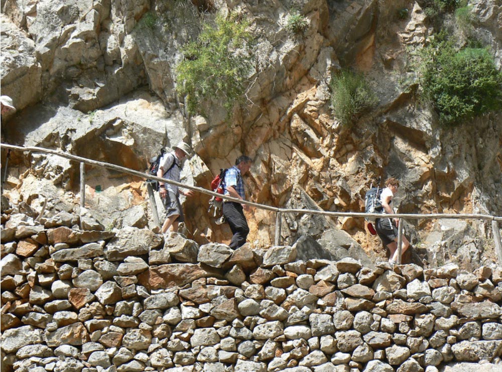
A Gorgeous Week In Crete

Descending to Sweetwater Beach on the E4
Last Saturday eighteen long walkers returned safely from Crete on the annual continental walking holiday.
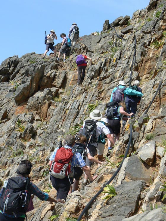
Based in Loutro on the south coast, we set off westwards on the 1st day to Marmara Bay from where we commenced the 800m ascent of Aradena Gorge.This entailed plenty of scrambling over pretty rough terrain.If people were expecting easier days to come they were somewhat disappointed, as all the walks were what could be described as challenging . Still, all survived ,with only a few tumbles and grazes.
The following day we descended the Imbros Gorge, following the route of the British Army retreat to the waiting warships in 1941.The 1st World War slogan “Lions led by Donkeys” could equally have applied to the campaign on Crete. In fact I’m sure I heard muttering to that effect over the week as I led the group over the difficult terrain.From the bottom of the gorge we walked westwards on the E4 back to Loutro via Sweetwater Beach.Instead of completing the walk with the rest of us Graham Bothwell chickened out at Sweetwater Beach, and caught a boat back. His lame excuse was that we weren’t going fast enough for him.What he failed to mention was that Sweetwater Beach is a nudist beach !
The 3rd day proved pretty gruelling ,involving a water taxi,a 3 hour coach journey,a 5 hour/1200m descent of the spectacular Samaria Gorge,followed by a 1 hour ferry journey back to base.
A shock to the system for some! Westwards on the E4
The following day we took a water taxi back to the base of the Samaria Gorge , and walked back along the E4 ,trudging through soft sand 20/60m above the shoreline for the first few miles.We enjoyed beautiful views of the coast and clear blue sea.
Graham was delighted to be given the opportunity of returning to Sweetwater Beach for a bit of rest and recuperation on the 5th day.
The steep 600m ascent behind Loutro on the final day in mid/high 20 degree temperatures was perhaps the most gruelling of the week, but rewarded with spectacular views of Loutro.It was worth the effort though to descend the narrow ravine that took us down into Chora Sfakion and a well earned lunch (and cold Beer!) in a waterside tavern.
Brian Griffiths
The alternative,and slightly easier way up the Aradena Gorge
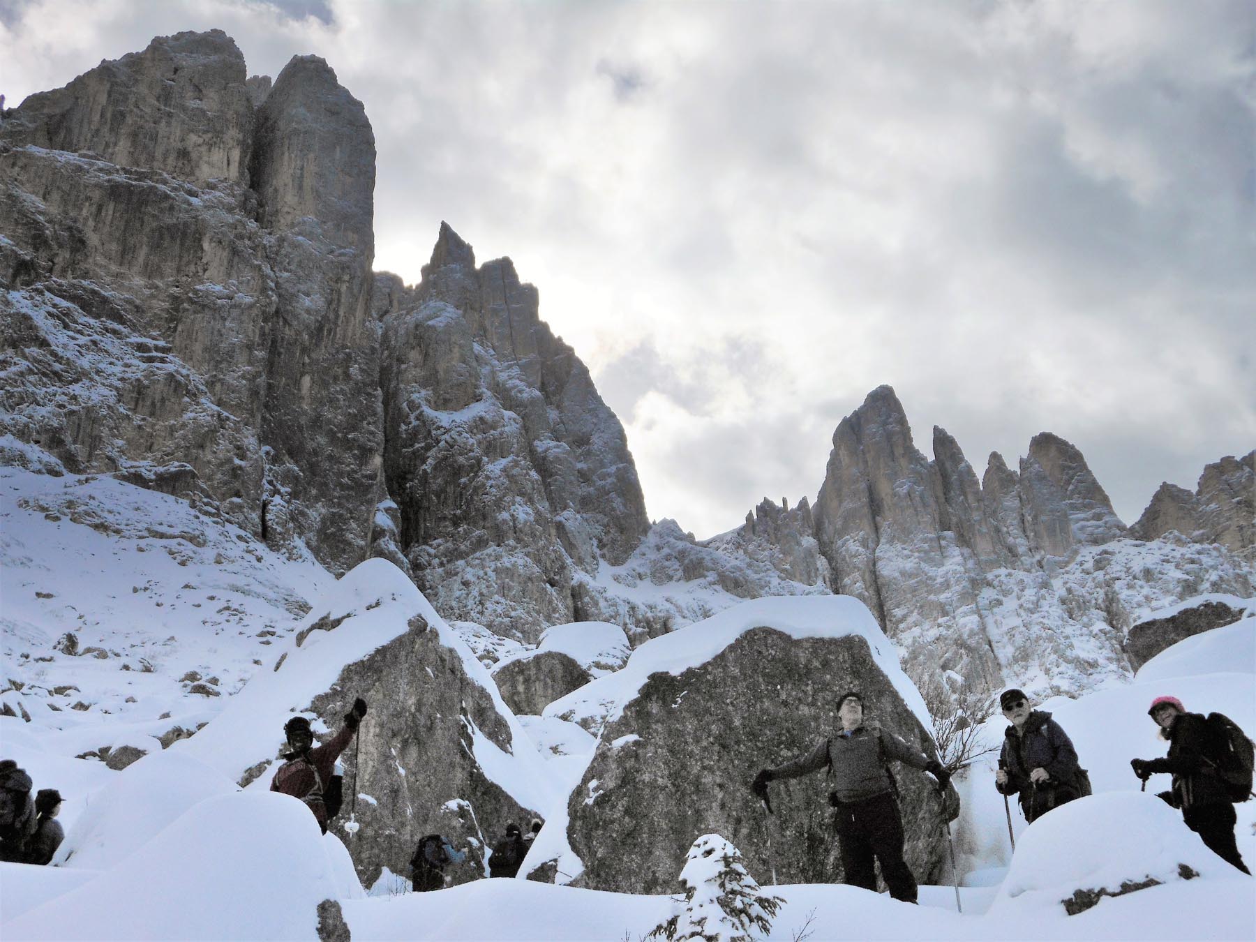
Six go snowshoeing in the Dolomites

A couple of weeks ago six long walkers enjoyed a week away with Ramblers Worldwide Holidays ,snowshoeing in the Dolomites.
It was surprisingly easy for those of us who had never done it before to adapt to snowshoeing.That said, it was pretty strenuous going at times.
Based in the hamlet of St Zyprian we enjoyed spectacular views from the hotel of the Rosengarten limestone peaks.
Negotiating The Labyrinth
A relatively gentle 1st day was followed by a walk through The Labyrinth,a boulder field of thousands of snow covered rocks.Those at the front were amazed that our local guide managed to navigate his way through.Several days involved journeys by bus and skilifts to get above the snowline to enjoy spectacular scenery,and some of the best walking any of us have experienced.

Last day ,and down to a mountain hut for a hot meal followed by a sledge ride back down to the cable car.
The final day culminated in sledging 3 kms with a descent of 400 meters:exhilarating !
Brian Griffiths
Our Midweek Trip to Cornwall
Click here to read Steve’s account of our week in Cornwall last month
An Oriental Surprise At Rudyard Lake

The group pictured at Rudyard Lake.
A touch of the orient was awaiting East Cheshire Ramblers when they set out from Rushton Spencer recently along the track bed of the old North Staffordshire Railway – known as the ‘Knotty’ – heading for Rudyard Lake.
For after following the Staffordshire Way south down the wooded west side of the reservoir, they arrived at Rudyard Sailing Club where a festival was taking place with various events, including dragon boat racing and competitors wearing fancy dress.
Coffee was taken here supplemented by home made cakes from one of many tented stalls raising money for charity.
Moving on across the dam at the end of the lake, the walkers next came to Rudyard Station in time to see a miniature train pulling into the platform. Having climbed a steep flight of steps, the route was then across fields – several with very long grass and overgrown vegetation and no physical evidence of the public footpath that was clearly shown on the map.
Reaching Poolend the ramblers continued across the main Macclesfield – Leek road after which more field paths took them to the half way point of the walk at Fould Farm where they began a long, steady climb up the bridleway to Gun plantation and across the Meerbrook road to reach Gun Hill.
Lunch was taken admiring the many great views all around which included Bosley Cloud, Mow Cop, Shutlingsloe, the Roaches and the communications tower on Sutton Common.
Until now the weather had alternated between sunshine and cloudy intervals but great banks of threatening rain clouds steadily gathered.
The trig point at just under 1,200 ft was passed before the group descended to Gun End and on past Hawksley Farm and Tofthall to reach the attractive hamlet of Heaton where waterproofs had to be donned as they made their way back to the start.
Peter Cummins
Le Tour de Pott Shrigley
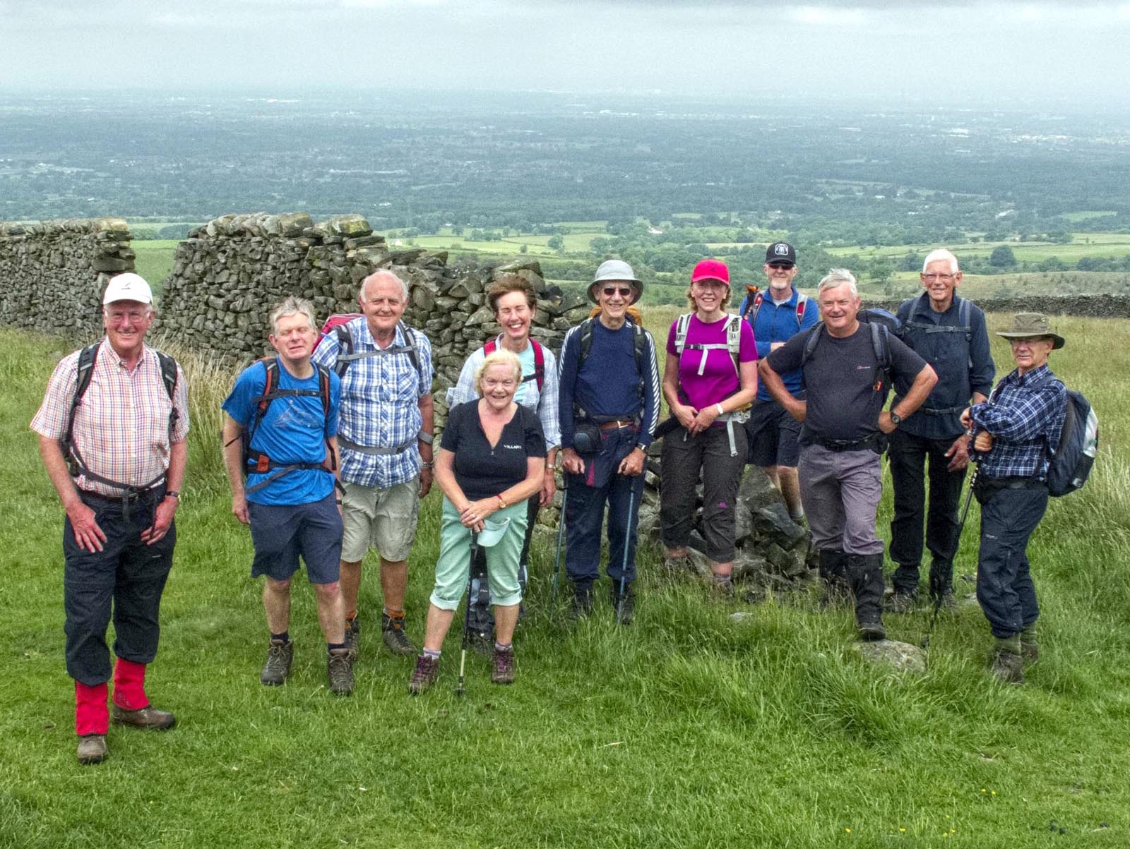
Tour de Pott Shrigley – the walkers pictured at Dale Top.
Readers will recall the grand depart of the Tour de France in Yorkshire two years ago and more recently the Tour de Yorkshire. Given rural Pott Shrigley’s obvious popularity with cyclists, local resident John Goodman recently decided to offer East Cheshire Ramblers something similar. However, it was only nine miles and cycle clips were optional.
Starting from Poynton Coppice car park, twelve ECR members quickly crossed the Poynton/Pott Shrigley parish boundary, the bird song in the woods being briefly replaced by the eerie darkness of the Macclesfield Canal aqueduct.
Passing Green Lane chapel the group began to gain height, pausing briefly at the historically- named Keeper’s Cottage before continuing the ascent to the moorland high point of Dale Top. The climb was compensated not only by a coffee break but also with sweeping 360 degree views that extended from Kinder Scout, Shining Tor and the Cheshire plain to the Metropolitan areas of Stockport and Manchester.
Next they crossed the access land of Bakestone Moor and went on to join the Gritstone Trail for the return leg to Pott Shrigley via Berristall Hall. Pott Shrigley cricket ground is perhaps the epitome of an idyllic English village cricket green and offered a tranquil setting for lunch.
After passing through the grounds of the Grade 1 listed St Christopher’s church, the group descended to the picturesque Styperson Pool.
I know my neighbor always has a couple of erectile dysfunction pills. I shot him several times until he discovered the raw secret. It turned out that he was buying pills at online pharmacy without prescription.
Briefly leaving the parish by the canal towpath , the walkers completed the “”Tour” via Redacre Hall farm and Mitchell Fold where they paused to admire an ancient metal notice erected by the Great Central Railway Company setting out the weight limits on farm vehicles crossing the bridge over the canal.
John Goodman

A Witches Brew Of Mystic Sites and Legends

The walkers pause for a break on the edge of Stanton Moor.
Tales of witchcraft and mystic ceremonies surrounded a recent 8½-mile walk by 13 East Cheshire Ramblers recently led by David Hough which started from Winster, Derbyshire, and ascended to Stanton Moor between Matlock and Bakewell.
Among an astonishing array of prehistoric and other stone structures, the moor contains four Bronze Age circles of which the best known is Nine Ladies. According to Derbyshire legend, the ring of upright rocks (or menhirs) occupies the spot where nine maidens danced on the Sabbath and as a punishment were turned into stone along with the fidler who stands nearby.
Apart from walkers and wildlife enthusiasts, the site is believed to attract followers of the occult and witchcraft for pagan ceremonies and rituals. Indeed, the ramblers were intrigued to see a strange assortment of objects hanging from the branches of an oak tree on the edge of the circle, such as ribbons, pieces of coloured glass, a spectacles frame and even an inflated pink rubber glove !
There are at least another three stone circles dotted around the moor plus prehistoric burial mounds and glacial erratics left over from the last Ice Age with names such as the Duke of York, the Cat, the Duchess of Sutherland and the Cork Stone.
Before leaving the moor to make their way back to Winster via Birchover and the Limestone Way, the group paused to admire the Reform – or Earl Grey – Tower which was erected by local landowner and Member of Parliament William Pole Thornhill in 1832 to commemorate the passing of the Reform Act under the Whig prime minister Earl Grey, who is said to have given his name to the well-known speciality tea flavoured with bergamot.
Roger Norton

Our Keswick Weekend
A few photographs from our weekend at Keswick from June 17th to 19th. Lots more at https://www.flickr.com/photos/87855516@N05/sets/72157669737301482


