[caption id="attachment_3434" align="alignnone" width="1024"]

The telecommunications tower on Croker Hill pierces the low level cloud as viewed from Macclesfield Forest (picture late 2015)[/caption]
Gillian Kay led this East Cheshire Ramble from Sutton Reservoir and with a 9.30am start the day had begun with bad light and drizzle and rain was forecast to spread in during the afternoon.
The path parallel with Sutton Reservoir was taken down to the Macclesfield Canal Towpath which was then followed to the swing bridge at Oakgrove. This locality is also known as Fools Nook which is said to have got its name by being one of the last places where Druids once lived and were referred to as ‘fools in the nook’. The area is also associated more recently with UFO sightings.
A track was followed up towards Gawsworth Common initially running south before doubling back as a muddy path alongside a leat. This minor waterway which is now no more than a trickle was built to capture water from the slopes of Croker Hill to supply the Macclesfield Canal. Many leats run into Bosley Reservoir which was built to store the water.
A morning break was taken prior to reaching Upton Fold Farm and here we veered left under the shadow of the BT Tower at Sutton Common. This reinforced concrete tower rises 238 feet and is one of a line of communication towers originally built as part of the 1950’s ‘backbone’ chain designed to provide the UK and NATO with survivable communications in the event of a nuclear war. Today there are seven identical towers in England with the only variation being their height. On Croker Hill we joined the Gritstone Trail northwards and made the long gradual descent over the Hill of Rossenclowes and down to Foxbank Farm. Turning right along the road then shortly left we next ascended close to Rossendale Brook to reach Higher Sutton. Once over another road we started a long gradual descent and stopped for lunch at the top edge of a field. We had made good progress and to date there was no sign of the rain which was forecast to spread in shortly. After lunch we continued around to join Clarke Lane in through Langley before taking the path which contoured along below Birch Knoll to reach the Macclesfield Golf Course. The route back to the cars was again via the canal towpath and field paths via Sutton Lane Ends.
The day was rounded off with afternoon tea at the Fairways Garden Centre.
[caption id="attachment_3432" align="alignnone" width="576"]

The array of communication installations on the tower at Croker Hill. (picture from 2008)[/caption]
[caption id="attachment_3433" align="alignnone" width="1024"]

A snowy scene on Croker Hill. The group took this route but sadly the weather on our walk was dull and gloomy. (This view taken in 2008)[/caption]




 The telecommunications tower on Croker Hill pierces the low level cloud as viewed from Macclesfield Forest (picture late 2015)[/caption]
Gillian Kay led this East Cheshire Ramble from Sutton Reservoir and with a 9.30am start the day had begun with bad light and drizzle and rain was forecast to spread in during the afternoon.
The path parallel with Sutton Reservoir was taken down to the Macclesfield Canal Towpath which was then followed to the swing bridge at Oakgrove. This locality is also known as Fools Nook which is said to have got its name by being one of the last places where Druids once lived and were referred to as ‘fools in the nook’. The area is also associated more recently with UFO sightings.
A track was followed up towards Gawsworth Common initially running south before doubling back as a muddy path alongside a leat. This minor waterway which is now no more than a trickle was built to capture water from the slopes of Croker Hill to supply the Macclesfield Canal. Many leats run into Bosley Reservoir which was built to store the water.
A morning break was taken prior to reaching Upton Fold Farm and here we veered left under the shadow of the BT Tower at Sutton Common. This reinforced concrete tower rises 238 feet and is one of a line of communication towers originally built as part of the 1950’s ‘backbone’ chain designed to provide the UK and NATO with survivable communications in the event of a nuclear war. Today there are seven identical towers in England with the only variation being their height. On Croker Hill we joined the Gritstone Trail northwards and made the long gradual descent over the Hill of Rossenclowes and down to Foxbank Farm. Turning right along the road then shortly left we next ascended close to Rossendale Brook to reach Higher Sutton. Once over another road we started a long gradual descent and stopped for lunch at the top edge of a field. We had made good progress and to date there was no sign of the rain which was forecast to spread in shortly. After lunch we continued around to join Clarke Lane in through Langley before taking the path which contoured along below Birch Knoll to reach the Macclesfield Golf Course. The route back to the cars was again via the canal towpath and field paths via Sutton Lane Ends.
The day was rounded off with afternoon tea at the Fairways Garden Centre.
[caption id="attachment_3432" align="alignnone" width="576"]
The telecommunications tower on Croker Hill pierces the low level cloud as viewed from Macclesfield Forest (picture late 2015)[/caption]
Gillian Kay led this East Cheshire Ramble from Sutton Reservoir and with a 9.30am start the day had begun with bad light and drizzle and rain was forecast to spread in during the afternoon.
The path parallel with Sutton Reservoir was taken down to the Macclesfield Canal Towpath which was then followed to the swing bridge at Oakgrove. This locality is also known as Fools Nook which is said to have got its name by being one of the last places where Druids once lived and were referred to as ‘fools in the nook’. The area is also associated more recently with UFO sightings.
A track was followed up towards Gawsworth Common initially running south before doubling back as a muddy path alongside a leat. This minor waterway which is now no more than a trickle was built to capture water from the slopes of Croker Hill to supply the Macclesfield Canal. Many leats run into Bosley Reservoir which was built to store the water.
A morning break was taken prior to reaching Upton Fold Farm and here we veered left under the shadow of the BT Tower at Sutton Common. This reinforced concrete tower rises 238 feet and is one of a line of communication towers originally built as part of the 1950’s ‘backbone’ chain designed to provide the UK and NATO with survivable communications in the event of a nuclear war. Today there are seven identical towers in England with the only variation being their height. On Croker Hill we joined the Gritstone Trail northwards and made the long gradual descent over the Hill of Rossenclowes and down to Foxbank Farm. Turning right along the road then shortly left we next ascended close to Rossendale Brook to reach Higher Sutton. Once over another road we started a long gradual descent and stopped for lunch at the top edge of a field. We had made good progress and to date there was no sign of the rain which was forecast to spread in shortly. After lunch we continued around to join Clarke Lane in through Langley before taking the path which contoured along below Birch Knoll to reach the Macclesfield Golf Course. The route back to the cars was again via the canal towpath and field paths via Sutton Lane Ends.
The day was rounded off with afternoon tea at the Fairways Garden Centre.
[caption id="attachment_3432" align="alignnone" width="576"]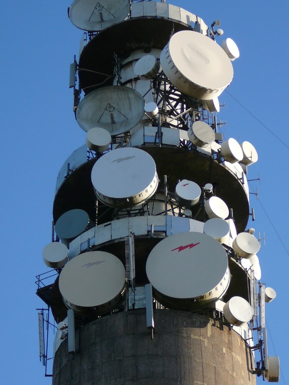 The array of communication installations on the tower at Croker Hill. (picture from 2008)[/caption]
[caption id="attachment_3433" align="alignnone" width="1024"]
The array of communication installations on the tower at Croker Hill. (picture from 2008)[/caption]
[caption id="attachment_3433" align="alignnone" width="1024"] A snowy scene on Croker Hill. The group took this route but sadly the weather on our walk was dull and gloomy. (This view taken in 2008)[/caption]

