Group walk report Monyash 12th Janaury

Despite the weather being quite miserable there was a healthy attendance of seventeen walkers for this long walk from Monyash lead by Nick Wild.
From the village, a brisk pace was set to warm us up as we headed north over countless slippery limestone stiles via Hard Rake. This area is owned by the National Park Authority and consists of a number of fields with flower rich grasslands. During the summer the fields are noted for ox-eye daisy, knapweed, hay rattle and meadow vetchling.
The enclosed track called Wheal Lane was followed to the southern edge of Taddington and here a sheltered spot was found for our morning break. To reach Chelmorton, our walk continued up over Sough Top, but now we were facing into a cold head wind. Entering the village we passed the historic village church which dates from the 11th century. The village which lies at around 300 metres above sea level is sheltered from the north by Chelmorton Low.
Heading along the village street and passing the historic Townend Farm, the group once more continued on field paths over to Sterndale Moor and once over the A515 stopped for a short lunch break.
It was a bleak, cold and very windy walk along the ridge skirting above the massive quarries at Hindlow and Dowlow. With drizzle in the air and cloud brushing the hills to the west, it was nice to get to lower ground.
In more favourable weather conditions the group continued along the track called Hutmoor Butts, and later turned right into Cross Lane, another track to reach Monyash. Everyone attended the tea room in the village to warm up after the walk.

No photographs were taken on the walk so I have included this one of Chelmorton which I took some years ago.

St John the Baptist Church at Chelmorton was passed on our walk but this picture was taken on a sunny winter day.

Group walk report 8th January

The group heading up towards Chinley Churn on a hazy morning.

It was one of those rare sunny days this year that coincided with the walk from Hayfield led by Ian Mabon. Despite it being a cool morning, fifteen walkers set out from the Sett Valley Car Park and initially followed the Sett Valley Trail for about a mile before heading south via the long ascent up Morland Road. With hazy views towards Kinder Scout it was good to be out on such a pleasant day. A sheltered spot was found in some old quarry workings for our morning break close to the summit of Chinley Churn.
Setting off, we now had a long gradual descent via Cracken Edge and down into the village of Chinley. Field paths were next followed passing White Knowl Farm, East Meats and Slack House and our lunch stop was taken on the sunny and sheltered side of a dry stone wall.
For the afternoon, it was a gradual ascent via Shireoaks to reach the Pennine Bridleway which was followed northwest to a spot just below South Head. Heading north, the moorland was in shade and the low sunshine casting long shadows as we descended to South Head Farm. A short afternoon break was taken near Coldwell Clough before rejoining the Pennine Bridleway for the walk back into Hayfield.
To complete the walk, many of the group visited Millie’s Tea Rooms for tea and cake with one person who shall remain nameless having a very large slice of cake.

As the sunshine is becoming a rare occurrence this year, I am including a few more photographs just to remind you what it is like when the sun shines!

A sheltered sunny spot below a dry stone wall for the lunch break.

View towards Roych Clough from above Shireoaks Farm.

Onward and upwards towards the Pennine Bridleway.

Heading along the Pennine Bridleway towards South Head.

Ian leads the party down towards South Head Farm.

When a walk goes not quite to plan.

Setting out from Barbridge on a cold but sunny morning.

During 2016 I decided to walk the newly created Two Saints Way, a 92 mile long pilgrimage trail running from Chester to Lichfield. My research showed that I could walk this as a series of linear walks using trains and buses, and being relatively local it would mean no overnight stays. The Two Saints Way has been created after the Saxon saints who brought Christianity from Northumbria to the ancient kingdom of Mercia in the seventh century. St Chad’s shrine at Lichfield and St Werburgh’s shrine at Chester were popular destinations for pilgrims in medieval times and are now linked by this route.

These two saints were key figures who lived at about the same time in the seventh century and by their labours they brought about a complete change in the religious and cultural landscape of Mercia. Mercia was a powerful kingdom between the seventh and tenth centuries, occupying a somewhat larger area than the Midlands today and including at its greatest extent all of England south of the Dee and the Humber and north of the Avon and the Thames.

Up to the last quarter of the seventh century, Mercia was still largely pagan but Christianity was reaching into Mercia from two different directions and had somewhat differing emphases. What some have termed Celtic Christianity had spread from Ireland via Iona to Lindisfarne in Northumbria through such personalities as St Columba and St Aidan. The kind of Christianity that was based in Canterbury in Kent was more deeply influenced by Rome.

For this section of the trail I had a plan to catch a bus from Barbridge to Chester then to walk back but alas, severe traffic congestion at Middlewich meant this would be unlikely. I had thought that I had given myself ample time to get to the start and now it was a mad rush to don boots and to cross the busy A51 to catch the bus. It was so frustrating to be just waiting there at the busy roadside to see my intended bus racing towards me at a fair pace of knots. The traffic was just too busy to cross and hence it was back to the drawing board and I returned to the car to re-plan my walk.

St Boniface Church at Bunbury.

After one false start I decided to walk to Chester then to catch the bus back. Much of the trail would be along the canal towpath and indeed my progress would be smart. I soon found my way crunching through hail which had not melted from the previous days’ storms. Now canal towpath walking is not my most favourite type of walking and to start with, I had to follow the Shropshire Union Canal to Bunbury Locks some three and a half miles and for much of the way it ran parallel with the busy and noisy A51. The bright start to the day was already giving way to the threat of showers as I left Bunbury Locks. The road into Bunbury wasn’t in my opinion exactly the best route as it was busy with traffic with no pavements and blind corners which meant repeatedly crossing the road. I wanted to visit the fine church at Bunbury but by the time I’d got there the sun had gone and the threat of some heavy weather to the west seemed imminent. Constructed mostly of sandstone, St Boniface’s Church is Grade I listed and dates mainly from the 14th century. It has been said to be one of the finest churches in England of this period. There has been a church here since the 8th century and the first church was a wooden construction. It was rebuilt during the Norman period with many later improvements with extensive work being carried out during Victorian times. In 1940, the church was seriously damaged by a land mine.

Shower clouds threaten as I make my way towards Beeston Castle.

Venturing inside there was a social gathering for the elderly hosted by the vicar and I was made more than welcome to join them for morning coffee. Having told the vicar that I was walking the Two Saints Way we had a common interest. He was a few days later going to run the Sandstone Trail in twenty four hours for a charity event. Fifteen minutes passed quickly and leaving the church the weather didn’t look too good but at least the heavy weather which was to the west of me seemed now to be passing to the south of me. For awhile it was good to be on footpaths and I soon crossed the A49. I had timed it well for my approach towards Beeston Castle with threatening clouds and a spell of bright sunshine made it good for photography. I rounded the castle on the eastern side before taking a path down to the Shropshire Union Canal once more at Wharton’s Lock. Again there seemed a real threat of some stormy weather as I trekked west along the towpath and I set targets to get to bridges where I might have to take shelter. As it turned out, I escaped very lightly with just a few spots of rain but the day had turned dull and quite cold. The sunshine did eventually return and at Crow’s Nest Bridge, a sheltered seat was an idea spot to have my picnic lunch.

I appear to be missing the showers but there are plenty around as I pass Tattenhall Marina.

Big spots of rain fall as I pass a long line of moored boats near Nixon’s Bridge near Tattenhall.

Canalside reeds and a view towards the village of Waverton.

I now had several miles of walking along the towpath and not vastly interesting. In places the opposite bank was lined with moored crafts but the day was made more interesting with bright sunshine interspersed with heavy clouds and the odd wintery shower and this did make for some good photography. I left the towpath briefly at Christleton for a short diversion to the church where I sat in the churchyard for a break. St James’ Church is Grade II listed and the present building dates from late Victorian times. It was partially rebuilt between 1874 -1878 after part of the nave collapsed during a service in 1873. During the English Civil War, the church suffered much damage. The tower however dates from the 15th century.

St James’ Church at Christleton and a pause here for my afternoon break.

I soon returned to the towpath again for the trek mostly on tarmac into Chester and by this stage it was proving a bit tiresome on the feet. Nearing the City Centre the Two Saints Way diverted down through Grosvenor Park before entering via Bridge Street to reach the Cathedral. I now had some research on getting the bus back as it didn’t run from the bus station but from Foregate Street and I timed it fairly well for the return journey to Barbridge.
(note this walk was undertaken prior to the new bus station in Chester being opened).

End or start of The Two Saints Way at Chester Cathedral.

Group walk report Thorpe Narlows Car Park 5th Janaury

Outside the historic Tissington Hall on a very grey day.

Despite a heavy cloud cover, the East Cheshire Ramblers had a healthy attendance for this walk from Narlows Car Park at Thorpe in Derbyshire.
Led by Sylvia Hill, the group set out towards Parwich following part of the Limestone Way. This 46 mile long path runs through the White Peak of Derbyshire but starts just over the border at Rocester in Staffordshire and finishes at Castleton.
After about two miles into the walk the group paused briefly at Tissington Hall. The hall is a fine 17th century Jacobean mansion and is grade II listed.
A morning coffee stop was taken in the churchyard of St Peter’s Church in Parwich. The present church was rebuilt in 1873 and incorporated into the building are some older parts including the original Norman doorway and chancel arch including a fine Saxon tympanum over the west doorway. The tympanum depicts the lamb of God with a cross, a stag trampling on a serpent, a wolf and a pig.
From Parwich, the group ascended via a wooded slope and later skirted Balidon Quarry before descending through Ballidon Dale to reach the tiny village of Ballidon. The little church which stands isolated in a field on the edge of the village dates from the 12th century. The building is now redundant with the last service being held there in 2003.
A series of field paths were followed generally southwest via Sitterlow Farm, Lea Cottage Farm and Woodeaves Farm and stopping on the way for lunch on a grassy slope. The last leg of the walk was via Fenny Bentley with a brief afternoon break in the village churchyard. This church dates from around 1300 and was heavily restored during Victorian times. To complete the walk involved a short ascent across fields to the start point.

The path between Tissington and Parwich taken during the winter of 2012 just to show that the sun does shine sometimes in winter. We used this path today and this view looks towards the Tissington direction.

Walk report 29th December Biddulph

Recently seventeen East Cheshire Ramblers led by Sue Munslow started their 5 mile walk at Biddulph Country Park. This parkland area in the 1800s was part of a larger estate owned by James Bateman a local colliery owner. The group walked through the Park along the Himalayan Path through the ancient woodland, with ferns and mosses covering the valley and alongside the brook flowing down through rapids and waterfalls. Leaving the Country Park, the local lanes and paths took us below Troughstone (a quarried gritstone outcrop) and from this hillside we had views across Cheshire to Queensferry Power Station, Jodrell Bank, Beeston Castle and the Wrekin in Shropshire. We eventually joined the dismantled railway now known as the Biddulph Valley Way.
The railway was partly financed By James Bateman to connect Biddulph to Congleton and Stoke, to move coal and other heavy materials. Closed during the 1960s the route way now is a valued by walkers and cyclists. Trees and hedge line the path providing a rich habitat for wildlife and nature reserves.
We returned to the Country Park passing the National Trust gardens which were originally developed by James Bateman as part of the original estate and now returned to their former glory by the National Trust.

Sue Munslow

Pausing on the Himalayan Walk at Biddulph Country Park

Hills that don’t disappoint

Setting out on the good track through the Nire Valley.

Few of us have heard of the Comeragh Mountains in County Waterford and in some respects, these mountains are often overlooked as the attraction of the highest mountains in southwest Ireland have got a greater appeal. From a distance, these are just flat topped hills with no real pointed summits but on closer inspection they hold many secrets hidden from view from the causal traveller.

I had walked in this area once before but I really wanted to explore the area in depth and set aside a full day to bag the main summits.
I’m setting out from my base in the nearby town of Clonmel and it is a relatively short drive to reach the empty Nire Valley where there is a good car park at the end of the surfaced road. On my arrival, the car park is empty and I set off under clear sunny skies. The high cloud of earlier in the day has almost melted away and ahead lies a semi circle of tabular hills dominated with steep north facing corries and flat tops which from this point have similarities to the Brecon Beacons.

I have not gone far when at my first stop to take some photographs I realise that I have left the camera disk behind in my lap top and that’s back at my Airbnb. At least I can take photographs on my mobile phone, however the quality won’t be as good. The downside is that I will be lugging my heavy camera around all day that I can’t use. It is a lesson for the future to always check your camera before setting out.

Heading up above the Sgilloge Loughs.

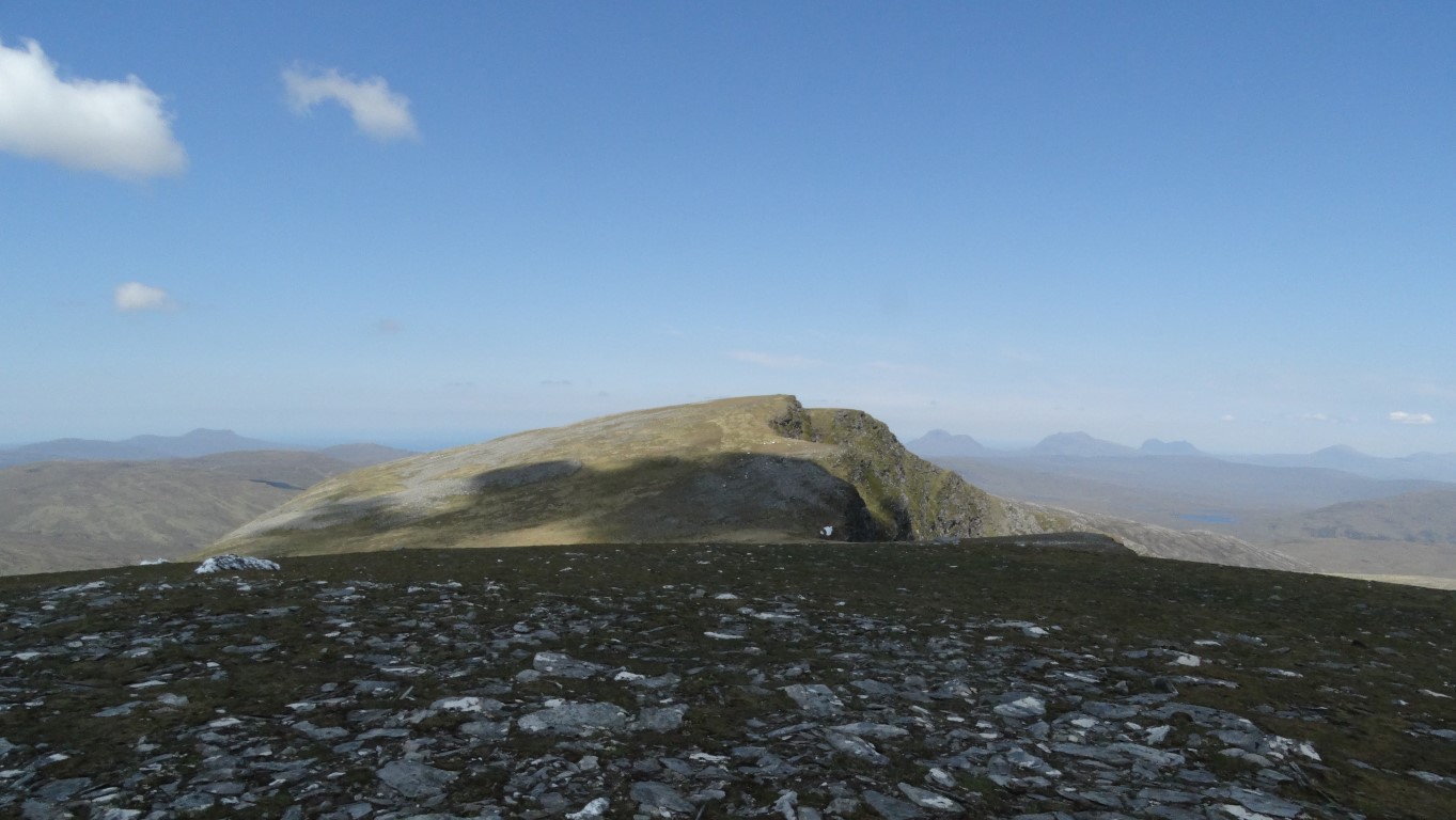
For now, I follow a signed path called the Nire Valley Trail with way markers to guide the way across the open moorland. After a half mile the path veers right into a shallow rocky valley to cross a stream via a hidden bridge. Beyond, the path climbs towards the hidden Sgilloge Loughs. (Lough is the Irish Gaelic name for lake) After a mile, but before reaching the loughs I turn left onto another path and at a high point leave this path to cut up across the northwest facing spur. I am aiming for the summit called Fauscoum, which at 792 metres is the highest point of the day. To get there it involves crossing a high level plateau of more than a mile and a half. Will this be a summit like Kinder Scout and how boggy will it be is the main thought I have in my mind? As my ascent levels out it becomes very much a stony desert. The surface vegetation has been stripped bare leaving a plateau easy to walk across. Here and there are isolated peat hags a couple of metres high and capped with heather. Ahead, a slight rise leads to the cairn on the rather flat summit of Fauscoum. In thick fog, this summit would prove a nightmare to find but today, it is perfectly clear. I have an area of short tussocky grass to negotiate before making to this very featureless summit. On a slight rise there is a good cairn but I don’t know where all the stone has come from on this peaty and stone free terrain.

The summit cairn on Fauscoum, the highest spot on the Comeragh Mountains but who brought all the stone here for the cairn?

I stop for my morning break in the warm sunshine and survey the view which stretches south to a hazy Waterford coast. Overall it is quite a boring summit but all that is about to change. I set off east a few hundred metres and quite suddenly the ground simply falls away to reveal an amazing lake filled corrie and one of the best examples of a corrie I have ever seen. It is quite awe inspiring and it seems that the ground had done a ninety degree turn. Coumshingaun Lough is ringed with 400 metre high cliffs plunging down to the lake. It is quite a breathtaking moment as I stand to take it all in. It is so vast that I can’t get it into one photograph. I walk south a little first then north taking many photographs of this spectacular natural feature. I spot another couple of people further on around the rim, who are just tiny specks on the rim of this magical amphitheatre.

Nothing quite prepares you for this jaw dropping view. Having trekked across a couple of miles of flat moor you are suddenly stopped in your tracks with this spectacular drop.

The corrie at Coumshingaun is the view to the left of the above photograph. It’s just too big to get into one photograph.

Eventually I leave the corrie rim and trek north across tussocky ground to gain the next corrie which faces north. Again this is spectacular but not as awe inspiring as the first corrie. A couple of small loughs occupied the floor of the corrie. Heading northwest I follow the northeast facing rim and in the process make a short detour west to bag the 767 metre summit of Carrignagower, which is the second highest summit in this range. The summit is ill defined and could be to top of one of several peat hags. Back on the rim, I stop for lunch at a high perch with a spectacular view east. This is the second day of perfect weather conditions on my fortnight holiday in Ireland and I keep asking myself will this be the last day of superb weather. (as it turns out, I have a fortnight of near perfect conditions)

The next corrie on my walk and this one is called Coum-Iarthar-Carrignagower.

Crossing The Gap, a wide col on the ridge and I’m heading for the third main summit of the day Knockanaffrin which lies beyond the nearest summit.

The rocky crest of the ridge to the leading up to Knockanaffrin from where this photograph is taken.

I want to walk as much of the ridge as possible and so after lunch I head northwest along the ridge and now pick up a path. A steep rocky descent soon follows to a spot called The Gap. On the descent I meet the New Ross Ramblers, consisting of a party of around twelve who walk every Tuesday. (I have in the meantime never found their website) After a chat I soon cross the col called The Gap and start to make the long ascent towards the rocky summit of Knockanaffrin 755 metres. The afternoon is proving quite warm and the summit is formed of a jumble of rocky outcrops which involves a little scrambling to reach the highest spot. I could turn back here but opt to press on to bag one more summit, and despite Knocksheegowna which lies about a mile further on being of a lesser height at 678 metres, it has a trig point. This summit is located on a steep knoll with the trig point located on the upper slope rather than on the actual top.

One of several rocky conglomerate outcrops along this ridge.

It is now time to head back to the car and I walk back towards Knockanaffrin but skirt around the western side of the rocky summit on easier ground and continue to a point where a path leads directly down to the car park completing this perfect walk.

New Year’s Day walk report

On the first day of every year, it has become an East Cheshire Ramblers tradition to take a welcome walk after the excesses of the festive season and toast in the New Year from a stunning viewpoint and 2019 was no exception. A group of 37 set off for a 6 mile walk on an almost spring-like day from Nelson Pit car park, Higher Poynton, to one of our favourite spots: Lyme Park. Having taken the canal path south from the Marina and crossed the footbridge nearest Green Farm, we entered Lyme Park via West Parkgate and through Hase Bank Wood. Before the 1850s the principal approach to the Hall was from this side of the park. The vistas on display are far more impressive than today’s approach from the A6. As you come out of the wood and skirt the The Knott hill, you glimpse The Cage hunting lodge through the trees and suddenly, as you turn the bend in the road, the south face of the Hall appears high and imposing above the sunken garden. Walking round to the north side of the Hall we set off along the ridge to The Cage, a favourite place to toast in the New Year in time-honoured fashion with sherry and mince pies. The Cage provides a wonderful vantage point for views within the park and beyond. To the South West through a gap in the trees, you can see the restored Paddock Cottage, another hunting lodge, and to the South East you can glimpse the The Lantern folly in Lantern Wood. It’s said that if Lord Newton could see The Lantern from his breakfast table, he knew it was a good day for hunting! As we looked beyond the confines of the park, we could pick out the Betham Tower in Manchester bathed in sunshine and the Pennines to the north shrouded in mist. Our return route took us down Cage Hill towards the main park gate and then west across a ladder stile out of the park. From here we followed Bollinghurst Brook and part of the Ladybrook Valley Interest Trail through undulating fields and woods. We crossed the Middlewood railway line and then followed a very pretty path through fields back to the canal path and Nelson Pit.

Melanie Davy

Toasting in the New Year at Lyme Cage.

Happy faces on the walk through Lyme Park.

Walking by the Macclesfield Canal.

Walk report 22nd December – Prestbury

A few minutes of magical sunlight on a otherwise dull December day.

Perhaps as nearly everyone was doing their last minute Christmas shopping there was only a small band of walkers setting off for this nine mile walk from Springfields Car Park in Prestbury. With the weather being rather showery, the group, led by Helen Menzies did a figure of eight walk and first set off from the village by heading southwest on Chelford Road before taking the path across Prestbury Golf Course. It wasn’t long before we had to take a path diversion to avoid the large construction site for the new King’s School but this did take us on a temporary path which was new ground for all of us and this skirted the south eastern edge of Big Wood.
After a coffee stop, the group headed through Big Wood to emerge onto the Chelford Road once more and headed west before taking the path north to Withinlee Road. This road then Castle Hill was followed back into Prestbury where the group stopped in Parrott’s Field for lunch. The church bells were ringing whilst we had our lunch on this rather grey winter’s day and afterwards we set off on our second loop east following paths to skirt Tytherington Golf Course. To reach Lowerhouse we walked via a rather muddy Dumbah Hollow and later via Mount Farm.
The highlight of the day came on our walk north to Whiteley Green when the sun finally decided to shine brightly for a few minutes to give some magical winter light backed by dark clouds. Setting a course for Prestbury, we headed along Holehouse Lane before taking the path to Butley Town then another path to the edge of Prestbury just as the afternoon light was beginning to fade.

The track southwest of Whiteley Green during a brief spell of bright December sunshine.

Walk report 19th December Bosley Cloud & The Bridestones

The group gathers for a photograph at the summit of Bosley Cloud.

After days of torrential rain, seventeen East Cheshire Ramblers were blessed with a mild winter day for our five mile walk led by Maggie Swindells from the picnic site at Timbersbrook up to Bosley Cloud and back. The top of The Cloud was shrouded in clouds as we set off but as the sun came out, the cloud melted away and we were blessed with sweeping views across three counties from the top! The dish at Jodrell Bank shone in the sunshine, a spectacular sight in the winter landscape. Bosley Cloud is a ‘Marilyn’, one of 175 in England! A Marilyn is a mountain or hill in the United Kingdom, Republic of Ireland or Isle of Man with a prominence of at least 150 metres (492 ft), regardless of absolute height or other merit. After sharing some Christmas chocolate treats and a hot cup of coffee, we wound our way down through the summer remains of brambles, blackberries and bracken to visit the Bridestones, a unique Neolithic monument.
The few remaining stones of this once great monument still stand along the line of the Cheshire/ Staffordshire border between the hillside of Bosley Cloud and Wolfe Lowe. The site is in desperate need of attention and recognition. Located at 820ft above sea level, the burial chamber lies on the western crest of a pass running in a north-south line at the foot of the Pennines and has spectacular views across the Cheshire Plain.
It is now a shadow of its former self with thousands of tons of stone having been taken from the cairn by the builders of the nearby turnpike road in 1764. Other stones were used to build the adjacent house and farm, while yet more were recycled into an ornamental garden in Tunstall Park. However, before this large scale ransacking occurred, it appears that the Bridestones was an incredible monument, perhaps unique in England.
From the Bridestones our walk meandered along the edge of a field full of sheep before dropping us gently down into the woodland and across a very wet bridge over a rushing stream. We climbed out of the woods and along a road edged with pretty stone houses and gardens boasting an array of Christmas lights and decorations before returning to our starting point in the car park.

At the Bridestones Neolithic Monument.

Getting to that remote Munro

It’s already a sweltering heat and unbroken sunshine as we climb out of the Inverlael Forest.

When it comes to bagging Munro’s, Seana Bhraigh is one of those summits which involves a long walk in and out and is usually bagged by itself.
It is the last full day in Ullapool for Nick Wild and I after a two week holiday of near perfect weather, and today the blue skies are holding with yet another hot day in the offing. We have just one outstanding Munro to bag in the area but this Munro is by far the remotest we are tackling. Seana Bhraigh lies away and well north of any other Munro and so this one will be the only main summit we aim to bag today.

The weather seems to be getting hotter as we arrive at the car park at Inverlael and we set off up along the same forest track as earlier in the week when we climbed Beinn Dearg and two other Munro’s. At the ruinous buildings at Glensguaib we are taking a winding and rocky side track climbing steeply onto the spur leading up to the spur called Druim na Saobhaidhe. With no breeze and a sweltering heat, we take many breaks and there is simply no shelter from the blazing sun. Well above the forest, the gradient begins to ease and the track by now has turned to a well defined path and so our progress is fairly good thanks to the occasional slight breeze. We ford the Allt Gleann a’ Mhadaidh and promise ourselves a paddle here in the refreshing water on the return. We now walk parallel to this stream some distance into the col to the north of the rocky crag called Creag an Lochain Sgeirich. Next, we walk beside Lochan Sgeireach which comprise a series of small lochans in a boulder field and the path weaves about a bit on this section and we continue by ascending to higher ground. Despite the heat, there is plenty of snow still lying around in this area and we stop at a high point for our morning break. We could imagine here that we are on the roof of Norway on this high plateau with warm sunshine and the snow fields all around.

Remote country. We had trekked over this plateau to get this far. The impressive corrie at Cadha Dearg falls away to the right on this photograph. Few people venture this far into the wilderness.

I had researched this walk earlier and from the information in the ‘Walk Highlands’ website, it suggests to head north to a col to the east of the rocky summit of Meall a’ Choire Ghlais. So leaving the path we head in this direction but due to the nature of the terrain it proves not such a good idea after all with steep slopes and several lochans to get around over the next mile. By the time we do return to the path, a party that we spotted earlier and well behind us are now well ahead. We contour around a deep corrie on our left named Cadha Dearg and this looks impressive and is ringed with cliffs but it’s a corrie that few people see. We are back on a path as we head north and we opt to take in the secondary summit at 905 metres first. On the ascent we spot a place of clean flowing water where we can re-fill our water bottles on the way back. Hopefully I will find this location again.

Seana Bhraigh in sight – our objective for the day.

On the 905 metre summit, the other party are already on Seana Bhraigh, a good half mile to the northwest. Heading in that direction, we pass them coming the other way but without rucksacks. Apparently they had left their rucksacks elsewhere and in conversation with them they are on quite an ambitious walk today and taking in several other summits. Meanwhile, we soon make it to the 926 metre summit of Seana Bhraigh and decide that it is a good spot to have lunch. Despite the summit being fairly flat, there are vertical cliffs a few metres away dropping to the impressive Luchd Choire which is ringed with cliffs all the way around to the satellite summit of Creag an Duine.

Nick on the summit of Sean Bhraigh with a view towards Creag an Duine.

A view back over the plateau we had crossed and had passed Beinn Dearg en route seen here in the middle of the photograph.

To the east, the summit of Creag an Duine looks worth a visit. It will add slightly to the walk and the trek around the top of the Luchd Choire seems quite appealing. After lunch we set off across the flat terrain, and the short vegetation makes the walking easy but there are steep cliffs on our left. From Sgor a’ Bharra, a slight rise leads up to the 892 metre secondary summit of Creag an Duine. The actual summit at 905 metres lies along a narrow rocky spur to the north which means a scramble to gain the summit. Nick opts to wait on the 892 metre secondary summit whilst I set off minus rucksack along the ever narrowing ridge. I haven’t gone far when I am stopped by a sheer drop down to a narrow col. It might have been a cliff face of around twelve feet but I can’t see any easy way down and it’s is not the sort of place to take a fall. I therefore cut my losses and return to Nick. It is a summit that has defeated us but it would have been time consuming to find an alternative route around this obstacle.

The shapely summit of Creag an Duine. Unfortunately a deep gash on this narrow ridge prevented me from getting much further. With more time, I might have found a way around it to gain the summit.

The north facing cliffs on Sean Bhraigh on a sweltering afternoon. We could pick out deer standing in the lowest and largest bank of snow in the shade.

From Creag an Duine we head southwest over the eastern shoulder of the 905 metre summit to reach the spot where we can recharge our water bottles. Descending, we opt to stay with the path which continues all the way to the point where had made the diversion in the morning. It is no wonder why the other party had surged ahead of us. The route back to Inverlael is as our outward route and following an increasingly good path. Progress is fairly good as we cover several miles without the need to look at the map. Reaching the Allt Gleann a’ Mhadaidh we opt for a long paddle in the relatively warm waters. It is a job to pull ourselves away from this idyllic spot and the paddle has brought life back into our feet. We later descend into the forest and rejoin the good track back to Inverlael. Again the afternoon is sweltering and we feel very satisfied that we have bagged this remote Munro on this glorious summers day. It has been a round walk of almost nineteen miles and much of it in a sweltering heat.

Almost back to Inverlael after a perfect but sweltering day in remote country.