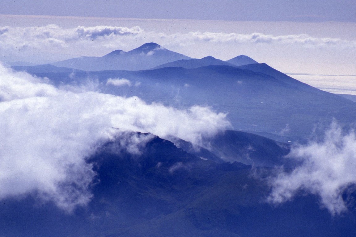
Islands above the cloud

Sea fog filters in from the Irish Sea to obscure the lower hills. Yr Eifl is seen in the distance.

I have been up Snowdon so many times and have approached it from all angles whether it’s been via the gentle Llanberis Path or via Crib Goch but this walk back in 1993 remains as one of the most memorable.
At the time with a young family, any strenuous walking usually took second place but wasn’t necessarily out of the question. For many years our annual holiday was in self catering establishments and our neighbours from two doors away joined us as they had children of similar ages. Our holidays took us to many parts of England and Wales and we always seemed to be dogged with bad weather with beach days clad in waterproofs rather than beach wear but alas our first full day of our holiday in North Wales dawned with perfect sunny weather and a chance to get a day of serious walking in.

The day started badly with one child in our party having severe toothache and hence this required a trip to Bangor Hospital for a tooth extraction and so the rest of us spent a morning on the beach at Dinas Dinlle enjoying the glorious sunshine.
As the hours slipped by, thoughts of any hill walking today looked slim but with a return of the others at lunchtime, there was still the possibility that my neighbour Tim and me making an ascent of Snowdon in the afternoon and returning in the evening.

It was a warm afternoon when Tim and I arrived in Llanberis which was our starting point and we soon set out toiling up the road leading to the Llanberis Path. This was our first ascent of Snowdon via this route and we chose it as we had a time limit and wanted to be back before dusk. As we ascended, then good views opened out towards Moel Eilio. We stopped at Halfway House for a much needed cup of tea before toiling on up the hot and dusty path. Beyond Clogwyn Station there was more breeze and after another half mile I suggested that we divert to take in the summit of Garnedd Ugain 1065 metres. The view from the top was breathtaking and came as quite a surprise after toiling up the mundane slope. By now sea fog from the Irish Sea was filtering in around the mountains so we pressed on smartly towards the summit of Snowdon in case we lost the views. From the top of Snowdon 1085 metres we were rewarded by excellent views. There was an ever changing cloudscape as sea mist edged in around Yr Eifl and Moel Hebog making them ‘islands above the cloud’. We spent nearly an hour on the summit savouring the views. Tim would have stayed longer but we still had some distance to go and it was already 6pm despite it being June.

On Garnedd Ugain with the first signs that low cloud was spreading in.

Late afternoon on the summit of Snowdon. The last walkers are leaving and now time to have the place to yourself.

A cloud ‘fallen from the sky’ hangs on the lower slopes over Nantgwynant.

Moel Hebog pokes out above the cloud ceiling.

The last train of the day about to depart from Snowdon Summit but we are not catching it. Note the old cafe complex.

For our descent we decided to return on the now deserted Snowdon Ranger Path to make a winding but easy descent to Bwlch Cwm Brwynog before an ascent to Moel Cynghorion 674 metres. The mist was now creeping over the lower summits but came and went from time to time. Our walk over Foel Goch 605 metres was mostly in cloud and ahead Moel Eilio was firmly into the cloud. We still had time to bag this peak but we wouldn’t get any views. The route was easy to follow as a boundary fence ran along the crest of the ridge and there was a path. Out of the mist appeared two walkers, the first we had seen since leaving Snowdon. On Moel Eilio 726 metres we rested awhile in the evening gloom. Momentarily the cloud lifted to enable us to get some photographs. Our descent to Llanberis was straightforward down the northeast ridge but we had lost the sunny end to the day but soon we were below the cloud. At the base of the steep slope we joined a track then lane to pass the Llanberis Youth Hostel. By 9pm we were back in Llanberis which left only a short walk to reach the car in a deserted car park to complete an excellent walk.

Group walk report Congleton to Macclesfield 30th January

Walking in a winter wonderland. A typical view as we neared the summit of Bosley Cloud.

I responded to Ralph’s plea to fill a gap in the Long Walks midweek programme and with this being a linear walk and using the train to get to the start I decided to leave the walk as planned despite a good fall of overnight snow. Other ECR walks had been cancelled but at least the trains were running to time and so I walked to Macclesfield Station expecting so see a few familiar faces.
In the end I boarded the 10.18am with not a walker in sight for the short journey to Congleton where I thought I might find one or two hardy walkers. Alighting at Congleton, it was only Sue Thersby who emerged from the rear carriage and so it would be just a very small group of two of us for the walk back to Macclesfield.

From Congleton Station we descended to join the towpath of the Macclesfield Canal. I had decided to wear my micro-spikes on my boots which initially worked well but as the snow was quite wet it rather stuck to my boots. From the towpath we joined the Biddulph Valley Way for a short distance before taking the field path to Overedge and then across more snowy fields to near Timbersbrook. We made good progress but trudging through the wet snow was proving tiresome. Heading uphill we crossed a lane before ascending a long flight of steps and at the top stopped for a late coffee stop. I was in two minds as to whether to walk up to Bosley Cloud as it was in thick fog but there was just that chance we might break out into bright sunshine. We didn’t, as the fog was thicker and the snow much deeper as we followed footprints towards the summit. On the plus side was that we were now walking through a winter wonderland with everything coated in thick snow. The view on top was nil but not quite white out conditions. With no breeze it didn’t feel that cold. We were soon off eastwards before descending steps to join a lane. Turning left along the lane we made the mistake of turning right too soon and so opted to headed down across fields and not on a path but at least at the end there was a gate. It was lane walking now down to the River Dane. The roads were virtually snow free which made walking with micro-spikes less easy.
Just prior to crossing the River Dane, we turned left along a muddy field path towards the Macclesfield Canal. With a thaw beginning to set in, conditions underfoot were proving quite muddy and wet. Reaching the Macclesfield Canal we stopped for lunch as it was now 1pm.
Again we set off in the afternoon gloom and murk with hardly a breath of air blowing. We wandered up through the Bosley Locks where a lone boat owner with his dog was making his way up through the locks. Reaching the A54 we left the towpath to follow Station Road before heading west on the private surfaced track towards North Rode. It appeared that the low cloud and murk was lifting and by the time we reach North Rode, there was the hint of sunshine nearby.

After the gloom, the sun was now beginning to break through as seen here near North Rode.

We now headed north towards Gawsworth across several fields with afternoon sunshine from time to time which made all the difference. At Gawsworth Churchyard I opted to remove my micro-spikes as we now had some road walking. It made the going much easier. A path along a snowy field was followed to the southeast of the village before following Lowes Lane through Mosshouses. A watery field path was next followed around passing Danes Moss Farm. We had no choice afterwards but to follow the busy A536 in towards Macclesfield but then we opted to take the unofficial path across the playing fields and rough ground to gain Moss Lane. We were back in Macclesfield by 4pm having made very good progress and timing it well for Sue’s train. The thirteen miles of walking had taken us just over five hours.

A slight thaw had set in by the time we reached Mosshouses. The roads were now clear of snow and the sun had made an appearance.

Group walk from Sutton Reservoir January 26th

The telecommunications tower on Croker Hill pierces the low level cloud as viewed from Macclesfield Forest (picture late 2015)

Gillian Kay led this East Cheshire Ramble from Sutton Reservoir and with a 9.30am start the day had begun with bad light and drizzle and rain was forecast to spread in during the afternoon.
The path parallel with Sutton Reservoir was taken down to the Macclesfield Canal Towpath which was then followed to the swing bridge at Oakgrove. This locality is also known as Fools Nook which is said to have got its name by being one of the last places where Druids once lived and were referred to as ‘fools in the nook’. The area is also associated more recently with UFO sightings.
A track was followed up towards Gawsworth Common initially running south before doubling back as a muddy path alongside a leat. This minor waterway which is now no more than a trickle was built to capture water from the slopes of Croker Hill to supply the Macclesfield Canal. Many leats run into Bosley Reservoir which was built to store the water.
A morning break was taken prior to reaching Upton Fold Farm and here we veered left under the shadow of the BT Tower at Sutton Common. This reinforced concrete tower rises 238 feet and is one of a line of communication towers originally built as part of the 1950’s ‘backbone’ chain designed to provide the UK and NATO with survivable communications in the event of a nuclear war. Today there are seven identical towers in England with the only variation being their height. On Croker Hill we joined the Gritstone Trail northwards and made the long gradual descent over the Hill of Rossenclowes and down to Foxbank Farm. Turning right along the road then shortly left we next ascended close to Rossendale Brook to reach Higher Sutton. Once over another road we started a long gradual descent and stopped for lunch at the top edge of a field. We had made good progress and to date there was no sign of the rain which was forecast to spread in shortly. After lunch we continued around to join Clarke Lane in through Langley before taking the path which contoured along below Birch Knoll to reach the Macclesfield Golf Course. The route back to the cars was again via the canal towpath and field paths via Sutton Lane Ends.
The day was rounded off with afternoon tea at the Fairways Garden Centre.

The array of communication installations on the tower at Croker Hill. (picture from 2008)

A snowy scene on Croker Hill. The group took this route but sadly the weather on our walk was dull and gloomy. (This view taken in 2008)

Retracing walks of my youth

Lunch stop on Black Hill with a panoramic view across Herefordshire and beyond.

During my youth, the Black Mountains and the Brecon Beacons was my stomping ground and there were countless weekends, when, along with my walking group we would venture out from Bristol on a Friday evening to spend a couple of nights in one of the youth hostels in the area whether it be Brecon, Crickhowell or the former Capel-y-ffin. The latter was one of my favourites and was tucked a long way up the valley of the Vale of Ewyas, a deep valley which dissected the Black Mountains and leads up to the Gospel Pass. In those days the easy part of the journeywas getting to Abergavenny before a drive along narrow winding lanes in the dark of night which seemed to go on forever. With a car load of passengers and full of rucksacks and provisions for the weekend I just hoped that we didn’t meet anything.

I was now back in Abergavenny for a few days with the plan of tracing some of the paths we took so many years ago and re living old memories.

Getting above the clouds. A cold air inversion over Herefordshire. I had started off from the bottom of the hill in thick fog but knew that as I gained height I would break through the cloud ceiling.

The Vale of Ewyas in the Black Mountains. To my left, the countryside below was still under a blanket of cloud.

It’s a fine sunny spring morning as I set off from the new Premier Inn in Abergavenny but I soon run into fog on my short journey north to the village of Longtown which lies under the eastern shadow of the Black Mountains. Parking by the village hall, I set out in the fog conditions but I know that there is the likelihood of fine sunny weather as I gain height. With paths well signed, I opt to take the field path west from the village hall and drop down to cross the Olchon Brook. On the far side I have a long gradual ascent and pass through Cayo Farm en route. I am some distance and height above the farm when the cloud above me starts to brighten. Gaining the steep open hillside the sun is soon visible through the cloud and it doesn’t seem long before I break out into bright sunshine under a deep blue sky. I hurry upwards as I need to gain height to get some photographs and reaching the ridge above Rhiw Arw I pause to take some stunning photographs. I’m in luck and what a morning it is with a sheet of cloud stretching to the horizon to the southeast. The Vale of Ewyas over to the west on the other hand was clear of cloud altogether.

My walk north is now along the Offa’s Dyke Path has several miles of high level walking on a good path on what is like walking along the ridge of a roof and passing two trig points on the way. I am soon passing the first trig point at 552 metres and continue north making good progress. What a day to be out I think. The cold air inversion is now dispersing as higher land to the east starts to pierce the cloud ceiling and after an hour the cold air inversion has gone.

Miles of ridge walking behind and ahead of me. This is the second trig point that lies on the English/Welsh border on the Black Mountains.

I continue north passing the second trig point at 610 metres to reach the highest land along the ridge at 703 metres. This is the county high point of Herefordshire and since joining the ridge I have been following the boundary between England and Wales. A bit beyond this high point, I leave the good path and head over rough ground to find the path leading to Black Hill. My plan is to have lunch on the summit, and having not passed anyone during the morning I now observe many people on the summit of Black Hill. Reaching the top, the place is awash with a large school party numbering around fifty. It certainly isn’t the place to have lunch or to photograph the trig point with so many children milling around the place. Instead I retreat to a quieter spot on the edge of the ridge to have my lunch. What a great spot this is with the countryside at my feet stretching away across Herefordshire towards the Midlands.

With the school party gone, I re-visited the trig point before heading southeast along the narrow roof shape ridge. This ridge is also known as the Cat’s Back, as viewed from the Herefordshire side it looks like a crouching cat about to pounce. It is an excellent walk which gradually descends before dropping down to a rough car park which today is full.

The ridge running southeast from Black Hill is also known as the Cat’s Back. It provides a mile of excellent ridge walking.

From here, I opt to take the path over Little Black Hill and down to Upper Blackhill Farm however, the path is ill defined and somewhere I lose it altogether. Eventually I am confronted by a field boundary with a stout fence and a steep almost vertical drop into a sunken lane. Searching around I find the correct exit to the lane.
The return to Longtown is now along narrow and often sunken lanes but at least there is virtually no traffic in this secluded corner of Herefordshire.
Reaching Llanveynoe on what was now a very warm spring afternoon I made a detour and find a seat in the shade of a yew tree beside the little church for a leisurely break in this idyllic spot. The church is dedicated to St Beuno and it is thought that St Beuno came to Llanveynoe in 600 AD and founded a small monastery on what was a pagan site. This was either situated where the church now stands, or on the site of Olchon Court, close by. Indeed, recent archaeological excavations in the grounds of the court have found what could be the foundations of a monastic building. Beuno was born in 560 AD at Berriew in mid-Wales, but his education was at Caerwent in South Wales under St Tangus (Tatheus). He was the nephew of that great Welsh saint, Cadoc, and his grandfather was King Brychan of Brecknock (Brecon). After a few years stay at Llanveynoe, Beuno headed north back to Berriew where he attended and ministered at his father’s funeral. From there he travelled north to the district of Tegengle and what is now Holywell, Flintshire, where his niece St Winifred was living. His most famous monastery was at Clynnog Fawr on the Lleyn Peninsula, but he established another 10 churches in North Wales. St Beuno died at Clynnog Fawr in 640 or 642 AD. (Note that our group visited St Beuno’s Church at Pistyll on our weekend walk from Trefor to Nefyn).

The little isolated church of St Beuno at Llanveynoe, which lies in the shadow of the Black Mountains. An idyllic spot to pass awhile for my afternoon break. The first real warm day of 2018.

A visit to explore the ruins of Longtown Castle to complete my walk.

Afterwards, I press on towards Longtown on a very gradual descending lane and finally in the village make a detour to visit Longtown Castle. The castle was built around 1175AD by Hugh de Lacy and was of an unusual construction with three baileys. In its heyday, a small town sprung up around the castle called Ewias Lacey. By the 14th century, the castle was in decline but was again pressed back into use during the Owain Glyndwr uprising in 1403. Having explored the ruins which are dominated by the circular keep it was then just a short walk back to the car to complete a perfect days walk.

Group walk report Sutton & Gawsworth 24th January

The main path across Danes Moss on a winter’s day. (photograph taken February 2015 on a much brighter day)

The starting point for this medium length walk close to Macclesfield was Bullock’s Lane Bridge at Sutton Lane Ends.
It wasn’t exactly a fine morning with very grey murky conditions and very poor visibility but a group of twelve walkers set off at 10am from Bullock’s Lane Bridge. We followed the towpath of the Macclesfield Canal at first then set out across Danes Moss before turning right and taking the field path to Mosshouses. Here we continued via Lowes Lane then a field path to Gawsworth where we stopped for our morning break in the park adjacent to the village hall where there were ample seats.
Heading west, we crossed the A536 to follow a rather busy Dark Lane and soon left this road and took field paths from Newbarn west then south before veering east to The Mount. Once back over the A536 Congleton Road, we took the field path to Gawsworth Church where we stopped for an early lunch stop. Despite it being mild, it had remained a very grey and gloomy day.
Heading east from Gawsworth we followed a field path and some notoriously muddy spots proved to be much better underfoot than expected. We later joined a lane before taking the farm track to Woodhouse Green Farm then a rather muddy path down to the Macclesfield Canal. We crossed the footbridge over the canal here work was being carried out on the bridge to replace the steps. Once over the A523, we took the path up beside Sutton Reservoir before taking the path beside the feeder channel that supplies water to the reservoir and in turn to the Macclesfield Canal. Later we veered left to cross fields to Sutton Lane Ends. In the village we took the path which reached Bullock’s Lane close to Sutton Hall. Here it was just a short walk to the cars and a few of the group ventured into Fairway’s Cafe afterwards.

Weekend Away To Ilkley 14 – 16 June 2019

Organiser’s Contact Details
The weekend is being run by Melanie Davy, Brooke Cottage, Church Road, Handforth Cheshire SK9 3LT

m.davy2906@gmail.com 01625 536511 / 07854 093785

Location
Ilkley is a spa town approximately 12 miles north of Bradford and 17 miles northwest of Leeds. The town lies mainly on the south bank of the River Wharfe in Wharfedale, one of the Yorkshire Dales. The town centre is characterised by Victorian architecture, wide streets and floral displays and it has a high number of small independent shops. It is also one of five towns to feature a Betty’s Tea room. Ilkley Moor, which overlooks the town, is part of Rombald’s Moor, which has the second highest concentration of ancient carved stones in Europe.

Hotel
Craiglands Hotel,Cowpasture Road, Ilkley, West Yorkshire, LS29 8RQ (01943 430001) www.craiglands.co.uk
Set in 6 acres of beautiful, landscaped grounds and woodland, Craiglands is just a short walk from the town and the famous Ilkley Moor.
I have visited the hotel and reserved 28 of the best rooms overlooking the valley.
Please don’t believe all the reviews on some of the review sites!

Hotel Cost

2 Nights (for Friday & Saturday night)

Single occupancy room: 2 night stay Dinner, B&B = £180

Double occupancy room: 2 night stay Dinner, B&B = £260

3 Nights (for Friday,Saturday & Sunday nights)

Single occupancy room: 2 night stay Dinner, B&B = £270

Double occupancy room: 2 night stay Dinner, B&B = £390

Hotel Booking

  • Reserve your hotel room through me using the attached form.

  • Deposit: Pay £25 deposit per person: £20 non-refundable deposit for the hotel and £5 recce fee per person.

  • Balance: must be paid to ECR by Wednesday 1st May. I will remind you a couple of weeks before this is due.

Please complete the attached form and pay your deposit and recce expenses as soon as possible. The hotel “rooms with a view” will be allocated on a first come, first served basis and will be held for ECR by the hotel until 5th April However, once the 28 rooms have gone, I cannot guarantee what rooms will be available, if any.

Non residents
If you don’t want to stay in the hotel, you are still very welcome to join us. Please complete the attached form as I will need your contact and emergency contact details and £5 recce expense payment. The hotel is very happy for you to join us for any of the evening meals at a cost of £25 per head. We hope that everyone will join us for the traditional Saturday night get together meal.

Payment Details
Click here to download a booking form

Walks
We hope to offer short, medium and long/long-medium walks on Saturday 15th and Sunday 16th June. This will be confirmed once walk leaders have been identified.

If anyone is interested in leading a walk, please let me know. I’m looking for short and long leaders.

A Talk About Canals By Duncan Learmond

CANALS – OUR ‘WATERY’ FOOTPATHS

A talk on the local canals by Duncan Learmond

FRIDAY MARCH 8TH 2019

7pm for 7-30pm at Macclesfield Tennis Club SK11 8LF

Duncan is an East Cheshire Ramblers Walk Leader, Secretary of Macclesfield Canal Society, a Boater and a Canal Adoption Work Party Leader ……….

Please support this event and maybe bring along a few friends.

Tickets £6, which includes a light supper, a licensed pay bar is available.

TICKETS CAN BE BOUGHT FROM
Jane Gay, Colin Finlayson, Sue Munslow, Kathryn Carty, Adrian Flinn, Dave Barraclough or Keith Anderson Maggie Swindells
16 Castle Hill Court
Prestbury
SK104UT
maggieswindells@gmail.com
07729 327 940
Cheques Online Payment
RA East Cheshire Group Bank : Unity Trust
Sort Code : 60:83:01
Account Number : 20229929
Event Reference : TLK

TICKETS WILL BE AVAILABLE FOR COLLECTION AT THE DOOR

Extended group walk report Liverpool City Walk 19th January

It’s not every day that you stumble upon something like this. This is called ‘The Liverpool Mountain’ A temporary modern art feature next door to the Tate Gallery at Albert Dock. Work of artist Ugo Rondinone

We are getting use to this latest run of dull murky days and this walk would be undertaken on yet another day of gloomy skies, a hint of drizzle in the air and poor visibility.

So it was just seven of us set off through Sefton Park on the southern outskirts of Liverpool at 9.30am on this Saturday morning. This large park covers 235 acres and was purchased from Lord Sefton in 1867 for £250,000 which in those days was a lot of money. In those days it was thought necessary to provide open spaces where local residents could breathe the fresh air away from the squalor of the cramped housing in Toxteth. The park was later surrounded by grand Victorian and Edwardian houses.

The Palm House in Sefton Park. It was pleasantly warm inside. (Photograph taken on the reconnoitre)

We made a small diversion early on to visit the Palm House in Sefton Park which wasn’t officially open but we were allowed in for a quick look. It was lovely and warm inside but we were soon back out in the cold. The Palm House is a Grade II three-tier dome conservatory designed and built by MacKenzie and Moncur of Edinburgh which opened in 1896. Liverpool millionaire Henry Yates Thompson gifted £10,000 to the city to fund the construction. It was designed in the tradition of Joseph Paxton’s glass houses and was stocked originally with a rich collection of exotic plants. During the Liverpool Blitz of May 1941 a bomb fell nearby and shattered the glass. It was re-glazed in 1950 at a cost of £6,163 with costs covered by War Restoration funds. A period of decline and deterioration culminated in its closure in the 1980s on grounds of safety but the building was restored and reopened in 2001.

Coburg Dock is one of several former docks now put to other uses. On our walk alongside the River Mersey we passed several similar sites. (Photograph taken on the reconnoitre)

We continued through Sefton Park alongside the boating lake and later walked via the wooded valley of the former Otterspool Creek. This little valley probably once was a tidal creek used by fishermen hundreds of years ago. Reaching the Mersey Waterfront we turned right along the promenade. The weather now looked so murky and even the far bank of the Mersey merged into the morning gloom. At least the drizzle was in our backs and we set a good pace towards Liverpool. A few people were out walking dogs together with a few joggers and plenty of speeding cyclists. Below Dingle we stopped for our morning coffee break in the gloom. The tide was well up and the fresh breeze was occasionally throwing a little spray onto the promenade. We soon pressed on towards Liverpool but the greyness of the day wasn’t warranting any stops for photographs. At least I was able to take several photographs on the reconnoitre when I walked it late last year. By late morning we were at the Albert Dock and here there were a few more people but again the place wasn’t that busy. Near the Tate Gallery we passed at a new feature which was being photographed by a number of people. A stack of large rocks all very brightly painted and called ‘The Liverpool Mountain’ was a new addition to modern art here. This new piece of art work was made by Swiss artist Ugo Rondinone and will be on display for a couple of years.

The clock on the Royal Liver Building and the largest clock face in the United Kingdom. The minute hand is fourteen feet long. (Photographed in 1991)

One of the Liver Bird’s up close from the top of the Royal Liver Building. It’s not until you are up on the roof that you can appreciate the sheer size of this feature. (Photographed in 1991)

We continued north to reach the Pier Head where there were a few seats for our lunch stop. It was still early and not even twelve noon but this was a good opportunity to stop before heading in through the dark alleys of Liverpool. But the only downside here was the number of pigeons and raucous seagulls. Nearby, the clock on the Royal Liver building was striking twelve noon. The clock faces are the largest in the UK (larger than that famous tower in London) and the minute hand alone is 14ft long. The Royal Liver Building is a fascinating building in itself and along with the neighbouring Cunard Building and Port of Liverpool Building is one of Liverpool’s Three Graces. Opened in 1911, the building is the purpose-built home of the Royal Liver Assurance group, which had been set up in the city in 1850 to provide locals with assistance related to losing a wage-earning relative. One of the first buildings in the world to be built using reinforced concrete, the Royal Liver Building stands at 322 ft tall to the top of the spires. The Liver Birds have the names of Bertie and Bella. The male, Bertie looks over the city and the female, Bella looks to the sea.The Royal Liver Building is now, however, only the joint-fourth tallest structure in the City of Liverpool, having been overtaken in height by West Tower, Radio City Tower and Liverpool Cathedral. (I was lucky enough to go on a visit up to the roof many years ago).

Liverpool Parish Church, now dwarfed by other buildings. It is hard to think that this was once the tallest building in Liverpool. (Photograph taken on the reconnoitre)

After a fairly short lunch stop we were off again and headed up beside the Liverpool Parish church which is dwarfed by other larger buildings around. It is hard to believe that this was once the tallest building in Liverpool. There has been a church on the site since 1257AD and originally the church grounds stretched down to the River Mersey. In 1361 when Liverpool was struck down by a plague, the churchyard was use as a burial ground. By 1699 the population of Liverpool had swelled to 5000 the church was too small for the congregation and a second church, St Peter’s was built. With many improvements made to the church, a spire was added in 1746 but sadly this fell into the nave during a church service in 1810 killing twenty five worshippers. During December 1940, a German air raid destroyed the main body of the church and rebuilding of it was only completed in 1952.

Heading through the rather quiet City Centre we soon passed the Town Hall which is a grade I listed building and has been described as one of the finest surviving 18th-century town halls. The present building dates from 1749 and stands close to the site of an older town hall.
Nearby in Castle Street, the architecture was of note with a variety of building styles. We now dived in through dark side streets passing the famous Cavern Club in Mathew Street as well as many night club type premises where Beatles music was blaring out. The shopping area of Liverpool was also fairly quiet as it was the period after the January sales.
Our group thankfully stayed close together and we left the centre via Mount Pleasant en route to the Metropolitan Cathedral. The biggest ascent of the day was up the steps into the calm of the Cathedral. We wandered around but on such of gloomy day, the light from the stained glass didn’t display its best. There was a peace and calm about the place with sombre music being played on the organ. Back out in the outside world the present day hit us. We headed now along Hope Street with the view ahead dominated by the large Anglican Cathedral. A crowd had gathered on one street where the Liverpool FC Coach was parked up with the player’s just visible inside.

The Metropolitan Cathedral. The steps was our biggest ascent of the day. (Photograph taken on the reconnoitre)

There is a magical array of stained glass depicting every colour inside the Metropolitan Cathedral. We took time to wander around this lovely building with the only sound of the organist playing sombre music.  (Photograph taken on the reconnoitre)

We took time in wandering around the Georgian Quarter in Liverpool. The houses were originally built for wealthy merchants and the area has recently been restored to its former glory. This is Falkner Street and a house in this street was the location of the recent BBC series ‘A house through time’. (Photograph taken on the reconnoitre)

We now headed down a side street into the heart of the Georgian Quarter. This area had seen mixed fortunes from homes of wealthy merchants to an area heavily bombed during World War II and almost an area of poverty before investment had brought the area now much sought after. In Falkner Street I showed the group where the BBC series ‘A house through time’ had been filmed. Nearby Canning Street displayed some grand architecture worthy of stopping to admire. We were now close to the Anglican Cathedral but today didn’t venture inside as most of the group had been there before. Designed by Giles Gilbert Scott the Cathedral was built in stages between 1904 and 1978 and today it is the longest cathedral in the world and has one of the tallest church towers in the world. During my reconnoitre I spent some time inside the Cathedral which included a trip up the tower which gives an excellent view over Liverpool. The Cathedral is almost unique in having ecclesiastical constables until this very day. Only three other cathedrals in the United Kingdom still have Cathedral constables.

We didn’t visit the interior of the Anglican Cathedral during our walk but I did make time to take a leisurely wander around the Cathedral during my reconnoitre including a visit up the tower. A lift takes you part way up before climbing up several staircases overlooking the belfry.

There is an excellent view over Liverpool and beyond from the top of the 331 foot tower. This was one of several photographs I took on the reconnoitre and looks over the City Centre.

The Chinese arch in Nelson Street is the largest such arch outside China. It was one of the many varied places visited on this fascinating walk. (Photograph taken on the reconnoitre)

We carried on to Nelson Street at the heart of the Chinese Quarter. The Chinese Arch at the north eastern end is the largest such arch outside China. We continued through the area lined with Chinese restaurants that you could have been mistaken as being in that country. We next skirted around to the southwest of the Anglican Cathedral before heading through the heart of a deserted Toxteth. This community has the unfortunate reputation of being associated with the riots but today is really a sleepy corner of Liverpool. Beyond we entered Princes Park which we crossed and after following a couple of roads were soon back in Sefton Park. We made for a cafe close to the Eros Statue. A short walk afterwards led us back to the cars.

Late afternoon sunlight through the trees in Sefton Park as seen on the reconnoitre but when we walked this at the end of our walk we had to contend with gloomy skies and bad light.

Group walk report Chelford to Holmes Chapel 15th January

It was yet another cloudy day for this linear walk from Chelford to Holmes Chapel. With a 10 am start, fourteen ramblers headed off south from the village following field paths on what was to be a fairly mild day. A road was briefly joined through Peover Heath before returning to field paths. With little recent rainfall, the walking was firm underfoot with few muddy areas. A morning break was taken near to Foxwood Farm. The farmhouse is grade II listed and has a plaque over the door stating the date it was built and by whom. Nearby, Jodrell Bank Telescope was always a dominant feature on the landscape, and during our walk the dish slowly tilted.
Later we made a small diversion to view the outside of Toad Hall which is believed to be the oldest building in the parish of Goostrey. It is now joined by the Old Medicine House, a timber framed building which originally stood in the village of Wrinehill near Crewe and was moved during 1970 to this location and rebuilt brick by brick. The owner’s wife gave us a brief history of the place. (hopefully we can arrange a couple of group visits in the summer – watch for details).
The churchyard at Goostrey was our lunch stop where there were ample seats for everyone. St Luke’s Church nearby is grade II listed and the former church was in existence prior to 1244AD. The original church was timber framed, but this was dismantled in 1792 and the present church built between 1792 and 1796.
For the afternoon, it was a relatively short walk across fields to Holmes Chapel and crossing on the way the historic Hermitage Bridge which dates from 1772 and spans the River Dane. Today the bridge was in the process of being re-pointed.
In Holmes Chapel we all managed to squeeze into Cobbles Tearooms for afternoon refreshments before wandering down to the railway station for the train back to Chelford.

The Dane Valley at Hermitage Bridge. Picture taken on a sunny day in November 2014 as today was so dull.

Expedition Rum

Kinlcoh Castle – our home for almost a week.

Forty square miles of moor and mountain with a population of only around twenty. Well this was to be our home for almost a week in April 1980. I had organised a party of seven from my local walking club at the time to spend several days exploring this very remote island in the Hebrides. Rum (or Rhum as it was called until 1991) is the largest of the Small Isles which lie between Skye and the Ardnamurchan Peninsula. The other three islands in the group also have unusual names and are named Eigg, Canna and Muck.
Getting to Rum was a small expedition in itself and loaded into two cars we set off north from Bristol taking three days to reach Mallaig. With no shop on Rum, we were going to take all provisions for the expedition to last us the week. So on a cold April day we were ready at Mallaig with twenty one items including suitcases, rucksacks and boxes of food to board the Caledonian Macbraynes Ferry which serviced the Small Isles.
After a uneventful voyage we needed to transport all our supplies from the ferry to a smaller boat out in Loch Scresort as in 1980 the ferry was too large to come alongside the small jetty.
Once safely ashore, our provisions and everything else that we had brought with us was loaded into a land rover for the short journey to Kinloch Castle. As for us, we had to walk along the track to the only community on the island.
The former servant’s quarters in Kinloch Castle would be our home for the week. We had now left the present day civilisation and had suddenly reverted back to the Edwardian period with no radio, television and no transport for almost a week and we were now castaways in a large sandstone castle miles from anywhere with no contact with the outside world.
Settling in, I had arranged that we all took it in turn to cook an evening meal as there was no going out to a restaurant. There just weren’t any. Our dining room consisted of a long table around which hung paintings of Highland scenes and an array of stag’s heads. Chandeliers emitting a dim light hung high above the table and over meal times our little group of seven were dwarfed in such a room. As for our entertainment, we took great amusement in John who being an amateur thespian took great delight in his ‘public addresses’ from the end of the long table. “Would the right honourable gentleman pass the salt” he would cry, then the cruet would be slid down the long table as if we were playing temping bowling.
Now Kinloch Castle has a fascinating history, not that it is all that old. Building work began in 1897 and all stone was imported from a sandstone quarry on the Island of Arran. Some three hundred craftsmen worked for three years constructing this state of the art building with all the latest inventions of the day being incorporated. It was the first private residence in Scotland to have electricity and a dam was built high on a stream above the castle to generate hydro electricity. But who was paying for this? We now have to turn to the Lancashire town of Accrington, home of the wealthy industrialist George Burrough who inherited along with his step brother half of his fathers’ business. His grandfather of humble beginnings had set up a textile business in the town and his father had grown the business into a big success and had improved the power looms in the factory. George’s father, John had a flair for business and the company went from Strength to strength and in its heyday employed over eight thousand workers.
John Burroughs initially rented Rum as a sporting estate and later bought the island. He died relatively young and the island was left to his son George whilst his other estate in Glen Lyon on the Scottish mainland was left to his step son.
George Burrough had big plans and Kinloch Castle was built to replace a small hunting lodge but as well as building the house, he had exotic gardens laid out with 250,000 tons of soil being imported to the island. The extensive gardens for which twelve gardeners were employed included greenhouses where fruits more associated with the Mediterranean were grown and a palm house which was reportedly full of humming birds turtles and small alligators.
The interior of the castle was lavishly furnished with no expense spared but the heyday of Kinloch Castle was relatively short due to the outbreak of World War I after which the castle was frozen in time. One unusual feature in the castle is the Orchestrion which is an electric organ driven by an electric motor that perforated card rolls. The organ was built around 1900 and apparently was destine for Queen Victoria who planned to install it in Balmoral Castle, but she died before it was complete and so it ended up here in Kinloch Castle.
In 1957 the castle and island was bought by the Nature Conservancy Council for just £26,000, the equivalent of roughly £1 per acre. Restoration work on the castle is ongoing to this very day.
As for our stay, we had planned several fairly strenuous walks and hoped to climb the Rum Cuillins on the day of the best weather. Setting off on the first day, we struck out west up the track through Kinloch Glen which runs into the heart of the island. Leaving the stony track after three miles we climbed into rough country and ascended the scree covered slopes to the summit of Ard Nev. Heading northwest we next made for Orval which at 571 metres was the highest summit of the day and afforded some excellent views. At a nearby sheltered spot we stopped for lunch. Continuing west we made for Sron an t-Saighdeir and here the moorland drops over 500 metres to the sea in less than one mile. Heading south we now made the long descent to Harris Bay on the south western side of the island. This is a lonely spot but is dominated by the Mausoleum. Built early in the twentieth century in the form of a Greek Temple it was erected by the Burrough family. This idyllic resting place for the family has been battered by gales and faces the full force of the Atlantic weather. At our time of visit it was in a poor state of repair. We now had a very long walk back across the island on a stony track to complete this sixteen mile walk.

The view towards the Island of Canna from the summit of Orval.

Lonely Harris Bay and its Mausoleum. Walking doesn’t get much more remote than this in the British Isles.


The Mausoleum at Harris. Now its a long walk back across the island.

Day two was an equally demanding walk with a trek up through Kinloch Glen again before taking the lonely path down through Glen Shellesder to the coast by which time it was our lunch stop. Trekking southwest along the coast we came to the deserted settlement of Guirdil which faced out towards the Island of Canna. The bay had a few roofless dwellings at the time of our visit but today there is a bothy there. The next part of our walk presented a challenge. Heading up Glen Guirdil we had to find a way up onto Bloodstone Hill on our right and eventually we found a gully which we zigzagged up to the 388 metre summit. Here the cliffs plunge directly down to the sea. At least from the top there was a path back to Kinloch Castle which squeezed through the gap at Bealach a’ Bhraigh Bhig and hemmed in between the rocky slopes of Orval and Fionchra. It had been another long day with over fifteen miles covered.

A view from the front door from a ruin croft at Guirdil. In the distance is the Island of Canna.

The 380 metre high cliffs at Bloodstone Hill. The name wouldn’t look out of place on a pirate’s map.

With no radio and not knowing what the weather would do, we decided to go for the Rum Cuillins on day 3, and today we split into an A and B parties. With me leading the A party, three of us were going to attempt the whole ridge. Cloud was down on the higher summits and we were hoping that this would lift.
From the castle grounds we left the woodlands and took a path up alongside Allt Slugan a’ Choillich which proved to be rather muddy and slow progress was made. We eventually reached Coire Dubh and veered left to reach Cnapan Breaca. The ‘B’ party led by John’s was not far behind us but going at a slower pace. Continuing south we reached the ridge leading up to Hallival and the last 150 metres proved a steep climb with many boulders to negotiate. Furthermore, the summit was in cloud. Other people were on the mountain and we were surprised to see so many. From the summit we set off south with an equally difficult descent to the col. Ahead lay a short stretch of easy walking but in the mist there were no views. Starting the ascent of Askival we were soon confronted by a rock wall going skywards. Was this the end of our walk? From conversations had at Kinloch Castle, the way ahead was to the left (eastern side). We edged our way along a steep slope over boulders with a rock wall on our right and nothing other than mist on our left. We picked our way upwards passing a number of Manx Sheerwater nests. This area is part of their main breeding ground with over a third of the world’s population in this area. We eventually made the 812 metre summit of Askival after a scramble. Views were nil so we didn’t hang around for long. Westwards we descended to Bealach an Oir, which was just below the cloud base and above the col we stopped for lunch. At Bealach an Oir we came across John and his party so we were puzzled how they managed to get ahead of us. Apparently, John had taken a wrong compass bearing and had dropped to low from Hallival and as a result had missed out Askival altogether. Shortly, my little group pressed on to bag Trallval 702 metres and this proved another steep climb. The summit ridge was so narrow that it would have been difficult to pass another person. The summit too was very small and we took it in turns to stand on the highest point. On all sides the slopes fell away steeply into the mist and it was such a pity that we hadn’t got any views. Our descent was southwards down to the col at Bealach an Fhuarain and this too proved to be a steep descent. In the col we turned left to walk down Glen Dibidil following the river much of the way. Reaching the coastal path, we turned left to follow the path back to Kinloch Castle. It remained a dull afternoon and despite not bagging the whole ridge, it had been an excellent walk.

On the Rum Cuillins with a view towards Hallival. We had traversed the ridge from left to right.

It was our last full day on Rum and by now most of the group were tired having done three days of strenuous walking. John and myself were both keen to visit the allegedly haunted Papidil Lodge which is located on the southern end of the island but this meant a walk of eight miles to get there and eight back via the easiest route. It wasn’t an early start and this made us late all day. Leaving Kinloch Castle, we initially followed a nature trail before a gradual climb to over 200 metres. The morning was dull and grey with the mountains firmly in the cloud. The going wasn’t that easy with several streams to cross. I kept leaving John behind and had to wait for him several times. The Dibidil River had to be crossed and this wasn’t that easy. Afterwards we dropped down to have lunch by Dibidil Croft. The building was used as a centre for local climbs. With time pressing we continued towards Papidil Lodge but at times we thought that we might not reach it. A stony path was followed to Loch Dubh an Sgoir. It was a long gradual descent before the ruins of Papidil Lodge came into view. I surged on ahead the last half mile. The ruined lodge lay among a group of trees.
Approaching the lodge I walked through some woods. There was a strange atmosphere as if I wasn’t alone. For the first time today the sun had come out and shone brightly. I wandered through the ruins walking from room to room in this once grand house. Furniture had been left in situ and shafts of sun light shone though the partially collapsed roof. It was a sheltered and sunny spot below Sgurr nan Gillean. John joined me to explore the ruins and nearby we sat awhile for a break close to the shore and Loch Papadil. With over eight miles to get back it would take us five hours. By the shore we stared out over an empty sea. Lots of driftwood and planks of wood littered the shore. Enough to make a boat and leave our desert island we thought.
From this idyllic spot we knew we had to return to Kinloch Castle. Heading back we opted to take a slightly higher route to reach Dibidil passing this time to the north of Loch Dubh an Sgoir. To our south east the island of Eigg had been bathed in sunshine all day. By 17.00 hours we had reached Dibidil. Towering above Glen Dibidil was Askival now bathed in afternoon sunshine. I was often some distance ahead of John but stopped periodically to wait for him. I re-crossed the Dibidil River but John opted to cross the river elsewhere and as a result fell in. I next saw him wading through heather with a boot and a sock held in one hand. We soon decided that I should press on as we were expected back by 18.30 hours. John would press on slowly. I set off at a quick pace crossing rough countryside and covered then remaining five and a half miles in one and three quarters hours. We kept a meal for John who surprisingly turned up just a half hour behind me.

The dark waters of Loch Papadil. Behind in the woods stand the ruins of Papadil Lodge. Haunted or not haunted, we felt that we were not alone as we explored the ruins.

On the eight mile walk back from Papadil Lodge to Kinloch Castle we had this view towards the Isle of Eigg.

For the last full evening at Kinloch Castle I had arranged the group to be given a tour of the building. It was just so amazing that a building of this stature was located in such a remote location. If anything, it would have made a good film location of Harry Potter’s Hogwarts Castle. From room to room we wondered around in amazement and through the castle packed with memorabilia that George Burrough had collected during his tours around various parts of the world. We were given a demonstration of the Orchestrion. The clarity was so magical and like an indoor fairground organ. The great hall had a ceiling painted in a heavenly blue and studied with stars. With the whole island being supplies by the hydro electric supply which was originally destine for the house, islanders always knew when the lights in the hall were switched on as the lights on the rest of the island dimmed.
It was soon time to leave Rum and with the group and other lined up on the jetty the following morning for the return journey back to the mainland and back to the present world. Overall it had been a magical experience.