A Path Improvement at Poynton, in Memory of Alan Catherall

Alan Catheral, sadly, passed away in January this year. Our ECR committee recognised a wish of our members to provide some permanent recognition of Alan for his enthusiastic and comprehensive contribution to the affairs of East Cheshire Ramblers Group, both in the countryside and management. Quoting from our Chairman Jane Gay “Alan has been a member of ECR since 1985. He was an extremely strong long walker and walk leader who enjoyed the mountains. He particularly enjoyed walking with other members of ECR and chatting to them about the countryside and his latest projects. He was passionate about improving access for walkers.”

Alan working at Back Dane concessionary path December 2017 (See Article “Restoring a Concessionary Footpath at Back Dane, Wincle – ECR Projects Team, November 2018” herewith)

It was agreed that Poynton-with-Worth FP 27, centred at SJ 9470 8270 between Elm Wood and Ben’s Wood would be improved, and a plaque in memory of Alan would be posted there. A kissing gate and finger post would be erected at the path’s north-eastern end, a waymarker post erected at an intervisible more southerly spot. At the southern section by the canal, hawthorn trees would be cut back to improve the path’s accessibility. At the south end, plastic fingers would be restored to an existing finger post, and its ground anchorage made more firm. This post is adjacent to a footbridge leading to Hagg Farm and Poynton Coppice.

Eight members of our ECR FP Projects Team assembled on site in July and carried out this work to everybody’s satisfaction. Assembling and placing the kissing gate……..

Clearance of hawthorn tree obstructions on the path by the Canal……….

A finger post was erected by the gate, and the fence meshed to the gate……..

Incidentally, we have adopted a protective system for posts against rotting, whereby a bituthene sleeve is wrapped around the post at its most vulnerable rotting zone (100 mm above, and 250 mm below ground level), melted and rolled onto the wood………

A waymarker post was placed midway………..and the bridgeside finger post was refurbished……..

Soon after, a site visit was made to attach the plaque to the new finger post……

My thanks go to Janet Allan, Roger Fielding, Adrian Flinn, Ken Hobbs, Roger Jubb, Ian Wasson and Nick Wild. They contributed to a team total of more than 39 hours of work, excluding breaks.

.

Signs old and new

 By Steve Hull

As one sign acknowledging our work appears, another disappears. The photographs show the pre-ECR sign on Tewkesbury Drive in Tytherington which has now disappeared, along with the stile and the associated footpath, which is buried under the new housing estate. The pleasant field path has been replaced by a longer and uglier Tarmac path round the edge of the estate leading directly onto the Middlewood Way.

                                                              Grey sign to the right of the stile erected in 1977

Details of sign at Tytherington.
New sign at Harrop Brook Footbridge.
Close up of sign at Harrop Brook Footbridge.

Group walk 7th March

On Stanage Edge.

By Michael Murphy

With improving weather, nine members of East Cheshire Ramblers ventured a little further afield on a bright March morning, for a 12 mile walk from Heatherdene Car Park, in Derbyshire. The forecast was for sunny intervals with moderate winds.
The route firstly ascended through mossy woodland, up onto Bamford Moor, where the group enjoyed splendid views across Ladybower Reservoir and the snow-specked hills beyond.
Having briefly strayed onto the wrong footpath (the distracted leader engrossed in conversation!) some “off-piste” descending was required to regain the correct route above Jarvis Clough, before stopping for our coffee break.
A long gradual climb followed, to access the rocky gritstone ridge known as Stanage Edge. What had been moderate winds in the valleys were now experienced as much stronger gusts, as the party headed South East along the jagged ridge.
Many walkers were encountered in both directions, taking the opportunity to enjoy the early spring weather, whilst using varying techniques cope with the wind.
Leaving the ridge, the group headed South West to the attractive town of Hathersage. Here they visited the churchyard of St. Michael, the reputed location of the grave of Little John, one of Robin Hood’s Merry Men.
The walk then crossed some boggy farmland to arrive at Bamford. The intended route would have used stepping stones at Bamford Mill, over the River Derwent. As these were underwater, it was necessary to extend the route to reach the Thornhill Trail. Now a bridleway, well used by walkers, cycles and horses, it was once the route of a narrow-gauge railway; built to carry materials used in the construction of the dam wall to create the Ladybower Reservoir, opened in 1945.
After walking the two-mile length of the trail, the group crossed the dam to arrive at the car park, before driving to Bamford for refreshments.

A path through the woods.

Group walk report 5th March

By Maggie Swindells

Ascending the staircase to Mow Cop Folly

After days of incessant rain fifteen East Cheshire Ramblers met on a rare sunny morning for the start of an eight and half mile walk from Congleton to Mow Cop and back. We set off along the Macclesfield Canal, one of the last narrow canals to be built; indeed, it was very nearly built as a railway! The mud along the tow path tested our stamina and skill in parts before leaving the canal at Ackers Crossing and taking a moderate, steady climb through fields and woodland to the summit of Mow Cop.
We reached Mow Cop, the southernmost outcrop in Cheshire of hard sandstone grit, which rises 335metres above sea level. We passed the ‘Old Man of Mow’, a gritstone pillar over 20 metres high, which was left after the quarry was last used. The Old Man used to be a rock climber’s paradise, but now is deemed too unsafe to climb. From there it was a short walk to Mow Cop ‘Castle’; a mock tower that was built as a summer house in 1754 by Randle Wilbraham, the Squire of Rode Hall. The tower, now owned by the National Trust, is visible for miles around and is a major landmark visited throughout the year. Mow Cop was also the first meeting place for John Wesley, who took the first Primitive Methodist service there in 1807. We were able to take a well-earned lunch break at the top of the ‘Castle’, sitting in the winter sunshine! This allowed us time to take in splendid 360 degree views across the Cheshire and Staffordshire countryside.
After leaving Mow Cop we walked along Congleton Edge, the final section of the Gritstone Trail; formed as a result of earth movements along the Red Rock Fault. Here the much older, often harder rocks of the Peak District and Pennines dip beneath the young sandstones and mudstones of the Cheshire plain. The ridge follows the Gritstone Trail to Nick i’th Hill, a pronounced dip in the ridge, believed to have been caused by a melt water drainage channel in the last ice age. From there we negotiated our way slowly down, through extremely muddy fields and water logged stiles, back to the beginning of our walk.

CORONAVIRUS – RAMBLERS ADVICE

Can you buy ambien online legally despite the restrictions associated with coronavirus and how safe it is?
The Ramblers have produced this advice on their website. Please take time to read it which is fairly well explanatory. click on link below.

Coronavirus – advice for members and volunteers

Finding a quiet place to walk on a bank holiday Monday

The large sandstone church at Baschurch dominates the village.

Finding a parking place in the Peak District on a bank holiday Monday can in some cases prove problematical and so last year on Easter Monday, I was joined by Steve Hull and Tony Littler to explore a area which was new to all of us and yet only around an hour and a half from Macclesfield.

Our starting point was in Baschurch in Shropshire which lies as the crow flies around seven miles northwest of Shrewsbury. The village is dominated by the large sandstone church of All Saints’ which dates from the 12th century. The interior however was fairly plain. Being not that far from Wales, the village name is first recorded as ‘Eglwyssau Bassa’ (Churches of Bassa). Setting off from the churchyard we headed south via good field paths to Milford then west via a lane before continuing on another field path. At Little Ness we paused for our morning break in the churchyard. The church unfortunately was locked but it seemed quite an ancient site and built on an area of land higher than the surrounding fields. Nearby was the mound of the motte and bailey castle. Whilst we were there, we met another couple of people out on an reconnoitre for the City of Birmingham Ramblers and doing an almost identical walk to us but in the opposite direction. We would meet them again later south of Ruyton XI Towns for another chat.

The ancient church of St Martins at Little Ness stands on a mound overlooking the peaceful Shropshire countryside.

Leaving Little Ness we now headed southwest on field paths to Great Ness and here the church was open. St Andrew’s Church is grade I listed and we briefly took a look inside. Nearby, we discovered that the A5 once ran through the village and came across an old milestone with distances to Shrewsbury and Holyhead. Not far away was the old village pump.

We found the church at Great Ness open on this fine spring day.

An old milestone in the village of Great Ness indicated that the main A5 once ran through the village.

We now headed towards Nesscliffe Hill Country Park but our intended footpath took a bit of finding as the stile was well hidden but after this there were no issues. We skirted the foot of the woodland and surprisingly came across a large hidden sandstone cliff in the trees. This was once a quarry area and the cliffs had been cut smoothly with historic initials and names cut into the rock face probably by quarrymen at locations which are now impossible to get to. We made for Kynaston Cave first which was located up a flight of worn steps and cut into the rock face but fenced off so there was no close access. The cave is so named as it became the secret home of ‘wild’ Humphrey Kynaston who in 1491 was declared an outlaw after the murder of local man John Hughes. For many years, this was his home where he lived a life similar to that of Robin Hood, robbing the rich and giving to the poor. Because of this, his hideout was kept secret despite the authorities trying several times to capture him. Of the two room cave, one room was for his family and then other was for his horse ‘Beelzebub’. It is believed that Humphrey Kynaston was later pardoned by Henry VIII after supplying the King with one hundred men to fight in France.

Well worn steps lead up to Kynaston’s Cave home for many years of the outlaw Humphry Kynaston.

Vertical sandstone cliffs are well hidden by the trees at Nesscliffe Hill Country Park.

A steep path led uphill to the wooded summit and we found a picnic bench for lunch. Nearby was the hill fort known as Nesscliffe Hill Camp which dates from the Iron Age. There are still extensive earthworks and recent tree felling had revealed the embankments.
We stopped briefly at Oliver’s Point where we had limited views through the trees to the west but today it was quite hazy. Leaving the wooded top we took a wrong turn and so had to back track a short distance and joined the lane through the hamlet of Valeswood. The path north over The Cliffe provided some fine walking along a low ridge on common ground and a small detour led us to the trig point that crowned the highest spot here. Again, views were poor but the walk towards Ruyton XI Towns was very rewarding.

Olivers Point on Nesscliffe Hill gives limited views across the Shropshire countryside.

Ruyton-XI-Towns is a fascinating village and west of the church are the remains of the castle.

Ruyton XI Towns is a place I’ve always wanted to visit as it has such an unusual name. It is unique in having the only Roman numerical in a name in the whole of Britain. The ‘XI’ comes from the small eleven hamlets once being amalgamated into one parish but now some of these hamlets are now in the neighbouring parish of West Felton. We headed for the church first and in the churchyard we came across the ruins of the castle. Little is left of the castle other than a few walls, and being close to the Welsh border, the castle was destroyed on more than one occasion. In 1308, an attempt was made to re-found the town as New Ruyton. It was awarded a charter briefly, but as raiding continued, the new town declined and lost most of its rights. The church of St John the Baptist was also visited and this building dates from the 12th century. We found a seat in the churchyard for our afternoon break.

We were grateful to the farmer who had cut a good path through the oil seed rape as we neared Baschurch.

During our rest time we could see a path from our vantage point which wasn’t marked on our maps. Steve and Tony opted to follow this as it was in the general direction that we would be taking. Meanwhile, I wanted to walk through the village to see what the place had to offer. I arranged to catch up with them at a pre arranged spot beyond the village and I arrived only a few minutes after them. We now skirted the upper edge of a wood then took a field path to join the lane towards the hamlet of Stanwardine in the fields. From there it was just a case of heading back to Baschurch but to add variety we opted to follow a couple of field paths and the second one was through a field of oil seed rape where thankfully the farmer had cut a good path.
Overall it had been a fascinating and varied walk from field paths, peaceful lanes, wooded hills and much of historical note and an area worthy of further exploration.

A circular walk around Walkden

The Aviary which stands above Old Warke Dam in Worsley was built as a hunting and fishing lodge by the 1st Earl of Ellesmere.

In a time when we have had so much rain, and near on seven inches this month in Macclesfield alone, it is becoming increasingly difficult to find somewhere to walk where you are not going to encounter waterlogged paths and fields or thick mud.
This week Steve Hull joined me on a walk where I hoped that we would find less in the way of flood water and hopefully not too much mud and in all but a few places this walk avoided most of these problems but not all.
I don’t think the ECR have ever walked from Blackleach Country Park which perhaps is an unlikely place to have a country park as it is located just off the Bolton Road in Walkden.
It was unfortunate that we arrived during a heavy hail and rain storm and having donned walking boots and waterproofs we spent the next few minutes in the car before the weather showed signs of improving. We set off on decent paths around the southern edge of Blackleach Reservoir and despite it still raining, brighter skies were quickly moving in from the west. It was only a short walk to reach the Rotary Way, – a surfaced path which ran along the former Bridgewater Collieries Railway. We were so glad that we weren’t crossing fields here as many were under water either side of the embankment we were on. After a half mile we left the former railway to follow a watery track then a field path which formed part of the Salford Trail. Gradually, conditions underfoot became quite waterlogged and so progress became quite slow for the walk to reach the Manchester Road. We crossed this road to join another watery path but had to revert back to the main road to pass beneath the M61 and M60 motorways.
Taking a track beyond, we soon entered pine woods and the driveway which led down towards the historic Wardley Hall. The hall is reputed to be one of the most haunted buildings in the country and dates from around 1500 although records show that there has been a moat here since 1292. It is the official residence of the Roman Catholic bishops of Salford. Preserved in a niche at the top of the main staircase is the skull of St Ambrose Barlow, one of the Forty Martyrs of England and Wales. On 10 September 1641 after confessing to being a Catholic priest he was hanged, drawn and quartered at Lancaster Castle. Ambrose was born at Barlow Hall, Chorlton-cum-Hardy in 1585 and the Barlow family had been reluctant converts to the Church of England following the suppression of the Catholic Church, but Ambrose converted back to Roman Catholicism in 1607. Despite being arrested several times during his travels, Ambrose was released without charge but on the 7th March 1641 King Charles I signed a proclamation which decreed that all priests should leave the country within one calendar month or face being arrested and treated as traitors, which would result in imprisonment or death. Ambrose’s parishioners implored him to flee or at least go into hiding but he refused. On Easter Day 1641 Ambrose and his congregation of around 100 people were surrounded at Morleys Hall, Astley by the Vicar of Leigh and his armed congregation of some 400. Father Ambrose surrendered, and his parishioners were released after their names had been recorded. Ambrose was taken to Lancaster Castle where he met his fate.
After crossing the East Lancashire Road we now continued towards Egerton Park and soon taking a muddy field path. We later passed beneath the M60 motorway a couple of times as we continued through Worsley Woods Nature Reserve. Here we found some seats for a morning break. The water level in the lake at Old Warke Dam was much higher than usual but at least by now we had some welcome sunshine. On the north western side of the lake stands The Aviary, a fine mid 19th century black and white house which was built by Frances Egerton, the 1st Earl of Ellesmere as a hunting and fishing lodge. Frances Egerton was a prominent British politician, writer, traveller and patron of the arts. The tenth largest island in the World, Ellesmere Island in northern Canada is named after him. Along with his large estate, the very profitable Bridgewater Canal, and the collieries at Worsley which also served as the headquarters of the canal made him a very wealthy man.

The Bridgewater Canal through Worsley.

The picturesque Packet House in Worsley.

We now entered the historic part of Worsley much of which is tucked away and out of sight of most passing traffic. The ‘village’ has many fine houses and reminded us very much of nearby Prestbury. The Bridgewater Canal dissects the village and the picturesque Packet House is a fine black and white building overlooking the canal.

Sculptures to prominant men in the area beside the Bridgewater Canal

Some good and dry walking along the towpath of the Bridgewater Canal west of Worsley.

Heading west, Steve and I struck out on the good surfaced path alongside the Bridgewater canal to reach the Boothstown Marina. En route, and to our right, the new RHS Bridgewater Gardens were taking shape. This will be a major tourist attraction when it opens later this year. The 164 acre site is being transformed into one of the largest new gardening projects in Europe.
We left the canal towpath at Boothstown and now had some walking via residential roads. We searched for a spot to have lunch but only found some seats at a small shopping precinct which was doing little trade.
Once over the East Lancashire Road once more we headed north and were soon back into open countryside and crossing the Busway with its associated ‘car traps’ We soon passed through the small hamlet of New Manchester before crossing some open ground to reach Engine Fold and prior to reaching this community we had to take shelter from a heavy shower of hail.

The busway north of Boothstown with it’s ‘car traps’.

We next joined the good path which followed the former Worsley and Bolton Railway Line, and for much of the way, this ran along a cutting. There was a sign where the former Little Hulton Station was once located. There was a station here between 1875 and 1954. Nearing the M61 we veered right to take another good surfaced path which ran back to Blackleach Country Park to complete a walk full of history through a landscape which has radically changed in the past one hundred years.

Cotswold wanderings

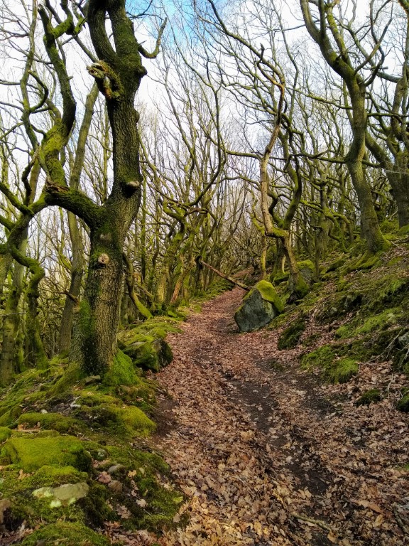
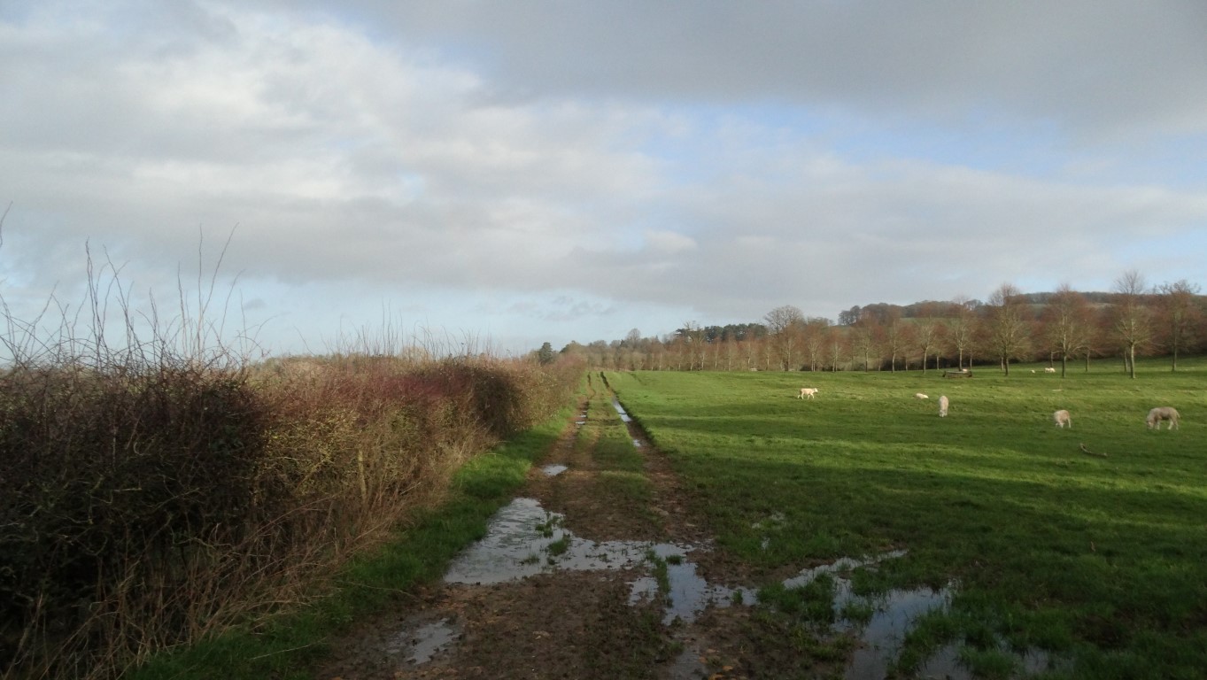
Now this wasn’t forecast, it was suppose to be a dry day. Walking on the approach to Wood Stanway.

Over the past couple of years I have been nibbling away at walking The Shakespeare’s Avon Way which runs 92 miles between Tewkesbury in Gloucestershire and Naseby in Northamptonshire.

With this trail being very much a riverside path I have for the time being had to put walking further sections of it on hold as much of it is now under water. My next trail I had planned to walk is the 42 mile long Winchcombe Way which does a figure of eight loop radiating out from the large Cotswold village of Winchcombe and so earlier this month I brought the first walk forward and set out on the initial walk of four planned walks to cover the northern part first.

I had planned to park in the small village of Buckland just south of Broadway but with neat verges and narrow village lanes there was probably nowhere really suitable. The same applied to the next village of Laverton but I was lucky in Stanton where I found a designated car park next to the village hall. The car park was empty as it was only 8.30am when I set off on this rather cold morning with the sunshine not yet up over the Cotswold escarpment.

The Winchcombe Way which concurs with the Cotswold Way north of Wood Stanway.

I opted to walk south first as I had walked this section northbound before as it concurs with the Cotswold Way which I had walked twice. With a heavy footfall, the path towards Stanway proved very muddy and not far out of Stanton the path was near on impassable as it ran between hedges and like many other walkers who had passed this way previously, it was far easier to walk in the adjacent field. Later, where the path crossed fields, the walking was much easier as I neared the deserted village of Stanway. The historic Stanway House was well hidden from view but the ornate gatehouse was impressive and dates from around 1630. Stanway House is of a similar age. In the village I passed Stanway Mill which started out life as a corn mill and later converted to a saw mill and dates from the 17th and 18th century. The building is occasionally open to the public.

I crossed the B4077 next, and continued via a field path to Wood Stanway. The walking underfoot was a bit better here but there was now a rainbow appeared to the west with a light shower approaching but from the weather forecast, it was supposed to be a dry day. In Wood Stanway I left the Winchcombe Way and turned left up through the deserted village with little sign of life. At the top end of the village the path was signed through a farm yard which now presented a problem as the yard was packed with heifers. There seemed no easy way to avoid these beasts and with my walking pole at the ready, I scaled a high metal gate to walk through the yard. The heifers thankfully were quite docile and backed off as I squeezed through. At the end of the yard I crossed another metal gate before setting out on the long gradual ascent across fields. The path led up to Stump Cross and at the Cotswold Escarpment I found a seat for my morning break. As I gained height, an icy westerly wind had picked up but at least this north facing seat had some shelter.

To reach the village of Ford, I headed north with the aim of joining a path running parallel to the lane. The path was quite overgrown and so lane walking was a far better alternative. Heading east I took a path along the northern edge of a gravel pit to reach Carey’s Covert. Red Kites were circling overhead as I skirted the eastern side of the covert. I later joined a lane south before following a short section of the B4077 into Ford which wasn’t that pleasant as it was narrow with no verges.

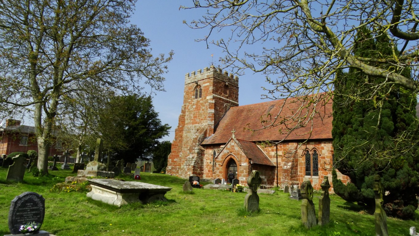
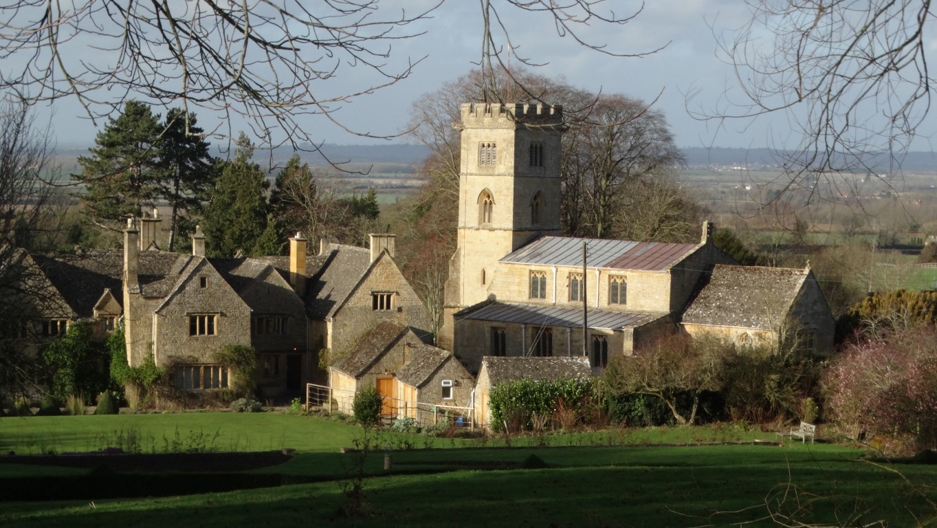
The little church at Cutsdean as seen from the Winchcombe Way.

A joy to be out walking the Winchcombe Way as I near the hamlet of Taddington.

The lane leading northeast towards the attractive village of Snowshill.

From Ford, I rejoined the Winchcombe Way and would stay with the trail all the way back to Stanton. Heading north, I took a pleasant field path to Cutsdean and soon caught up a small group of walkers who turned out to be on a HF walking holiday based at nearby Bourton on the Water.. We chatted before I soon pressed on as their pace was quite slow. North of Cutsdean I took a path to the next village of Taddington and here I turned left to follow a field boundary to reach another lane. I was aiming towards the attractive village of Snowshill and pressed on north on a lane then track and for now the day was quite pleasant. I wanted to bag a trig point which lay just off the path. Access was quite easy via a track but the trig point was quite camouflaged. Back on the main track I soon turned right across a field then followed a lane into Snowshill. I now looked for a suitable place to have lunch and after a wander around the centre of the village I found a seat by the village hall but like everywhere else in the village it was a cold spot and with another shower heading in from the west I didn’t stop long for lunch. Snowshill lies high up in the Cotswold Hills and faces northwest with higher ground to the east and south. It is quite a cold spot so you don’t need much imagination to see how it got its name.

A view from my lunch stop in Snowshill. What the photograph doesn’t show is the bitter wind blowing. Time to move on.

I was rewarded with this rainbow after a brief but heavy shower shortly after leaving Snowshill.

I soon headed north along the lane with spots of rain falling. To my left was Snowshill Manor which is now in the care of the National Trust. As I turned left off the road to descend on a field path it rained heavily for a couple of minutes and I was soon rewarded with a vivid rainbow as the sunshine returned. A walker coming the other way remarked that the path ahead was extremely muddy and indeed this was no understatement. Liquid mud which was also very slippery covered the path up the slope opposite. Aided with my walking pole I was just glad that I was going uphill instead of downhill.

After a long descent from the Cotswold escarpment I came to the attractive village of Buckland.

The track running north towards Buckland Wood was also very muddy with water filled ruts. To reach Buckland I descended across several fields and with some longer grassy areas I was able to clean off my very muddy boots which were now caked with sticky Cotswold clay. I joined a lane through Buckland then followed a good surfaced path south to Laverton. In the village I turned left uphill before taking a field path towards Stanton taking care not to get my boots muddy once more. Finally I headed down through the attractive village of Stanton to reach the car. It had been a fine walk on one of those better days this year.

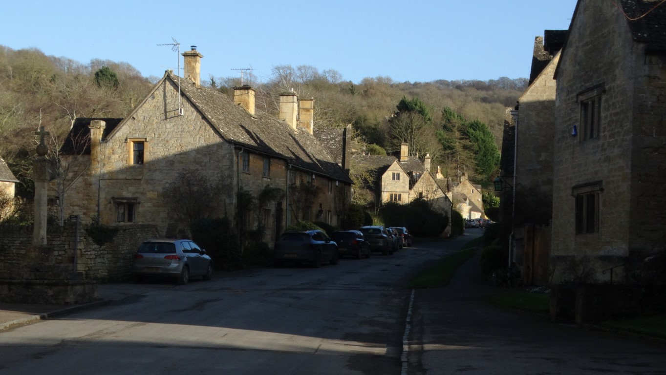
The end of my walk with a walk through the attractive village of Stanton.